
Nuoro
| Nuoro | ||
|---|---|---|

|
|
|
| Country | Italy | |
| region | Sardinia | |
| province | Nuoro (NU) | |
| Local name | Nùgoro | |
| Coordinates | 40 ° 19 ′ N , 9 ° 20 ′ E | |
| height | 554 m slm | |
| surface | 192.27 km² | |
| Residents | 35,763 (Dec. 31, 2019) | |
| Population density | 186 inhabitants / km² | |
| Factions | Lollove | |
| Post Code | 08100 | |
| prefix | 0784 | |
| ISTAT number | 091051 | |
| Popular name | Nuoresi | |
| Patron saint | Santa Maria della Neve | |
| Website | Nuoro | |
 Nuoro seen from Monte Ortobe |
||

Nuoro [ ˈnu.o.ro ] ( Sardinian : Nùgoro ) is a city in north-eastern central Sardinia and, as the capital of the province of Nuoro, an important administrative center and the gateway to Barbagia . The city is located on the expressway that forms the east-west axis of the island and has 35,763 inhabitants (as of December 31, 2019).
geography
Nuoro is located in the center of the island at the foot of the Monte Ortobe mountain on a plateau about 600 m above sea level. M.
history
Nuoro (as Nogoro) was first mentioned in the 12th century, it belonged to the Torres judiciary at that time and was rural for a long time. In 1779 it became a bishopric . Nuoro was promoted to town at the beginning of the 19th century, at that time it had less than 4,000 inhabitants. At the end of the 19th and the beginning of the 20th century Nuoro experienced a cultural boom, which earned the city the name "Sardinian Athens". Nuoro was made provincial capital in 1927 during fascism , after which it developed more rapidly.
Culture and sights
The Cathedral of Santa Maria della Neve was built from 1834 to 1873 in the classical style and is an example of this style in Sardinia.
The Monte Ortoben is the local mountain of the Nuorese. The toe of the statue of the Savior on the summit turned gold through regular touching. It is the destination of the pilgrimage at the Festa Redentore (Redemption Festival) at the end of August.
The Maria Frunza necropolis on the granite slopes of Monte Ortobe consists of five Domus de Janas , the complex of "Ianna Ventosa" and four other graves. The Nuraghe Tanca Manna is located on Via Mughina, in a park on a granite outcrop on the southern outskirts.
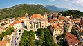
Aerial view with a view of the cathedral

In the cathedral

Statua del Redentore

Toe of the savior

Sagra del Redentore


Viticulture
A specialty is the traditional way (fermentation over three to four weeks instead of a few days, as is usual today), often made from the Tannat grape. Due to the relatively high cultivation in the mountains, the grapes are increasingly exposed to sunlight, whereby UV radiation can influence the polyphenol synthesis in grapes. This wine is considered to be one of the reasons for the special longevity of the inhabitants of Nuoro, because polyphenols have a retarding effect on endothelin synthesis.
traffic
Nuoro has two connections to the SS 131 dir , at the western exit there is a large industrial area. The traffic flows mainly through some larger streets, the small alleys are partly only passable for small cars or not at all for motor vehicles.
Nuoro has been the terminus of the narrow-gauge Macomer – Nuoro railway since 1889 . The passenger trains on the route built by Strade Ferrate Secondarie della Sardegna have been operated by Ferrovie della Sardegna since 1989 .
Daughters and sons of the city

- Grazia Deledda (1871–1936), writer (awarded the Nobel Prize for Literature in 1926 )
- Francesco Ciusa (1883–1949), sculptor
- Salvatore Satta (1902–1975), author of the well-known work The Day of Judgment (1977)
- Massimo Pittau (1921-2019), linguist
- Maria Giacobbe (* 1928), author of a teacher's diary
- Franco Oppo (1935–2016), composer
- Marcello Fois (* 1960), writer
- Gavino Murgia (* 1969), jazz saxophonist and singer
- Salvatore Sirigu (* 1987), soccer goalkeeper
literature
- Kristine Jaath, Peter Höh: Sardinia. Reise Know-How Verlag, Bielefeld 2002, ISBN 3-8317-1285-9 . P. 529ff
Web links
- Website of the city of Nuoro
- Nuoro - Monuments and Monte Ortobe
- Nuoro - cultural capital of the Barbagia
- Live longer with the right red wine
Individual evidence
- ↑ Statistiche demografiche ISTAT. Monthly population statistics of the Istituto Nazionale di Statistica , as of December 31 of 2019.

Aritzo | Arzana | Atzara | Austis | Bari Sardo | Baunei | Belvì | Birori | Bitti | Bolotana | Borore | Bortigali | Cardedu | Desulo | Dorgali | Dualchi | Elini | Fonni | Gadoni | Gairo | Galtellì | Gavoi | Girasole | Ilbono | Irgoli | Jerzu | Lanusei | Lei | Loceri | Loculi | Lodine | Lodè | Lotzorai | Lula | Macomer | Mamoiada | Meana Sardo | Noragugume | Nuoro | Oliena | Ollolai | Olzai | Onani | Onifai | Oniferi | Orani | Orgosolo | Orosei | Orotelli | Ortueri | Orune | Osidda | Osini | Ottana | Ovodda | Perdasdefogu | Posada | Sarule | Silanus | Sindia | Siniscola | Sorgono | Talana | Tertenia | Teti | Tiana | Tonara | Torpè | Tortolì | Triei | Ulassai | Urzulei | Ussassai | Villagrande Strisaili