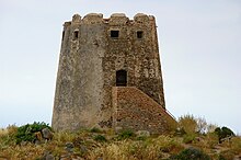
Bari Sardo
| Bari Sardo | ||
|---|---|---|

|
|
|
| Country | Italy | |
| region | Sardinia | |
| province | Nuoro (NU) | |
| Local name | Barì | |
| Coordinates | 39 ° 51 ' N , 9 ° 39' E | |
| height | 51 m slm | |
| surface | 37.53 km² | |
| Residents | 3,973 (Dec. 31, 2019) | |
| Population density | 106 inhabitants / km² | |
| Post Code | 08042 | |
| prefix | 0782 | |
| ISTAT number | 091005 | |
| Popular name | Bariesi | |
| Patron saint | Beata Vergine del Monserrato | |
| Website | Bari Sardo | |
Bari Sardo (Latin: Custodia Rubriensis ) is an Italian municipality in the province of Nuoro on the Mediterranean island of Sardinia with 3973 inhabitants (as of December 31, 2019).
After the Italian unification , the previous name “Bari” was changed to “Bari Sardo” in 1862 in order not to be confused with Bari in Apulia .
The small town has grown together from four settlements and is located about 4 km from the coast, about 80 km northeast of Cagliari and about 10 km south of Tortoli .
Bari Sardo is located between the Su Pranu , Pitzu e Monti hills and the Teccu plateau . There are numerous rock tombs ( Domus de Janas ) and towers ( nuraghi ) and menhirs ( Sa Perda Longa ) , some of which are very well preserved .
Web links
Commons : Bari Sardo - Collection of images, videos and audio files
- Barisardo.net. Retrieved December 31, 2009 (Italian).
- Comune di Bari Sardo. Retrieved December 31, 2009 (Italian).
Individual evidence
- ↑ Statistiche demografiche ISTAT. Monthly population statistics of the Istituto Nazionale di Statistica , as of December 31 of 2019.
- ^ The province of Sardinia and Corsica. Retrieved December 31, 2009 .
- ↑ Barisardo. Retrieved on October 12, 2018 (German).
- ^ Archaeological map of Bari Sardo. Retrieved October 12, 2018 (Italian).


