
Samos
| Samos | ||
|---|---|---|
 |
||
| Waters | Mediterranean Sea | |
| Archipelago | Southern Sporades | |
| Geographical location | 37 ° 44 ′ N , 26 ° 50 ′ E | |
|
||
| length | 44 km | |
| width | 19 km | |
| surface | 478 km² | |
| Highest elevation | Vigla 1434 m |
|
| Residents | 32,977 (2011) 69 inhabitants / km² |
|
| main place | Samos | |
 |
||

The Greek island of Samos ( Greek Σάμος ( f. Sg. ), Turkish Sisam ) is located in the eastern Aegean Sea and is off the Ionian coast of Asia Minor . It has formed the Samos regional district ( Περιφερειακή Ενότητα Σάμου Periferiakí Enótita Sámou ) in the North Aegean region since 2011 and has been subdivided into the two municipalities of Anatoliki Samos and Dytiki Samos since 2019 . The island has 32,977 inhabitants (2011).
The main town is the eponymous city of Samos , formerly also called Kato Vathy (Κάτω Βαθύ) or Limin Vatheos (Λιμήν Βαθέος).
geography
The island of Samos is located in the East Aegean Sea and is off the coast of Asia Minor . In the southeast, the approximately 6 kilometers long and at the narrowest point only 1.7 kilometers wide strait separates the island from Mykali (Στενό τής Μυκάλης, also strait of Samos, Στενό Σάμου; Turkish Dar Bogaz ; ancient name Epta stadia, Επτά στάδια) Turkish mainland. Together with Ikaria, Samos forms the northern end of the Southern Sporades . The shortest connection to the main island of the Fourni archipelago is less than 7 kilometers from the southwest coast. Ikaria is 19 kilometers west, Chios 67 kilometers northwest, the Dodecanese islands Agathonisi 19 kilometers south and Patmos 35 kilometers southwest.
With an area of 477,942 km² Samos is the eighth largest island in Greece. From Cape Katavasi (Ακρωτήρι Κατάβαση) in the west to Cape Gatos (Ακρωτήρι Γάτος) in the east, Samos reaches its maximum length of over 44.3 kilometers. The width in the center of the island between the Kavos Avlakia (Κάβος Αυλάκια) in the north and the Kavos Samiopoulas (Κάβος Σαμιοπούλας) on the south coast is 19 kilometers and less than 5 kilometers in the east of the island.
The relief of the island is over 60% hilly to mountainous with heights between 150 and 900 meters. The proportion of mountains with heights over 900 meters is more than four percent, with the two massifs of the Kerkis (Κέρκης) and the Ambelos Mountains (Άμπελος) dominating . Flatlands and plains up to 150 meters high take up almost a third of the island's area with almost 160 km².
The Kerkis massif rises steeply from the sea in the west and reaches a height of 1434 meters with the Vigla (Βίγλα). The foothills of the centrally located Ambelos Mountains (Άμπελος), with the 1153 meter high Karvounis (Καρβούνης) as the highest mountain, extend in the north and south to the coast. In the far east, the Thios mountain range rises to 453 meters.
To the northwest lies between Kerkis massif and Ambelos Mountains , the level of Karlovasi . The largest plain of the island, the plain of Chora (Κάμπος Χώρας, Kambos Choras) borders the southeastern foothills of the Ambelos Mountains , further east follows the plain of Mesokambos . The Vlamari plateau (Βλαμάρη) lies east of Vathy.
Although the coastline is poorly indented, the island has some protected harbors. On the south side there are two large open bays, the Gulf of Marathokambos (Κόλπος του Μαραθόκαμπου) in the southwest and in the southeast the Gulf of Pythagorio (Κόλπος του Πυγαγορείου), also known as the Bay of Tiganiνινινινινινινινινινινινινινινινινινινινινινινινινινινινινινινινινινινινινινινινιν Τρμος νηνινινινινινινινινιννινινινινιν Τρμος νηνινιν Τρμνς νηνιν νρμος Τρμνς νηννιννινινιν ιρμνος Τρμος . In the northeast, the approximately 5 km deep and 1 km wide Gulf of Vathy (Kolpos Vatheos Κόλπος Βαθέος, also Gulf of Samos) forms one of the largest natural harbors in the Aegean.
In the northeast of the coast are some uninhabited islands. The inhabited island of Samiopoula is off the south coast.
climate
The climate of Samos is characterized by mild, rainy winters and warm, dry summers. It is assigned to the Csa climate . The continental influence of mainland Asia Minor is evident in the higher amounts of precipitation and cold winds in winter. In connection with a humidity of 65%, frost days can occur. Due to the slow warming from January to March and higher average summer temperatures compared to the mainland of Asia Minor, the oceanic character of the island can be recognized.
The annual average temperature on Samos is 19.3 ° C. The summer average temperature is 25.8 ° C in July, the average temperature in January is 10.8 ° C. In July and August, the daily maximum temperatures can reach more than 40 ° C. However, especially in coastal areas, the sea breeze causes a significant drop in temperature. In the period from 1955 to 1997, the absolute maximum temperature at the airport weather station was 41 ° C and the absolute minimum temperature was −3.4 ° C.
Due to the high mountains and the proximity to mainland Asia Minor, the amount of precipitation on Samos and the neighboring island of Ikaria is high compared to other Aegean islands; it is comparable to the amount of precipitation in western Greece. The distribution of precipitation differs regionally and seasonally. While in the period from 1955 to 1997 the weather station at the airport recorded 709 mm on the south side with less rain, it reached 917 mm from 1987 to 1992 at the Ydroussa weather station at 210 meters in the north of the island. At higher altitudes, values over 1000 mm are to be expected. The seasonal distribution of precipitation is typical of the climate . Precipitation is concentrated in the wet and cold season, with an average of 169 mm in December as the peak value. During the last few years there has been a significant decrease in the amount of winter precipitation. The summer is characterized by a dry period of five and a half to six months, the average minimum rainfall is 0.4 mm in August. The rare snowfalls are limited to a maximum of two days per year.
Northern winds prevail on Samos. The Meltemi blows constantly from the north in July and August. The winds in November and December can definitely be stormy.
Samos is one of the sunniest areas in Greece, the annual sunshine duration is 2884.8 hours.
|
Average monthly temperatures and rainfall for Samos
Source: National Meteorological Service of Greece, 1955–1997 weather data Samos
|
|||||||||||||||||||||||||||||||||||||||||||||||||||||||||||||||||||||||||||||||||||||||||||||||||||||||||
fauna
4 amphibian and 24 reptile species have been identified on Samos:
Amphibians:
Turtles
Agamas
Chameleons
Geckos
Lizards
Skinks
To sneak
snakes
- Typhlops vermicularis
- Eryx jaculus
- Malpolon insignitus
- Natrix natrix
- Dolichophis caspius
- Eirenis modestus
- Hemorrhois nummifer
- Platyceps najadum
- Telescopus fallax
- Zamenis situla
- Montivipera xanthina
Administrative division
The island of Samos formed a province of the same name before 1997 (gr. Eparchia ). With the implementation of the municipality reform according to the Kapodistrias program in 1997, the 35 municipalities to date were merged into a total of four municipalities. On January 1, 2011, the Kallikratis program brought these four communities on the island together to form the newly created community of Samos ( Δήμος Σάμου Dímos Sámou ), the administrative seat was the city of Samos. In 2019, this community was divided into the two communities Anatoliki Samos and Dytiki Samos , each with two districts. The old 35 municipalities elect their own local representations as city districts or local communities.
| local community | Parish | Greek name | code | Area (km²) | 2001 residents | Residents 2011 | City districts / local communities (Δημοτική / Τοπική Κοινότητα) |
location |
|---|---|---|---|---|---|---|---|---|
| Anatoliki Samos | Vathy | Δημοτική Ενότητα Βαθέος (Σάμου) | 560101 | 125.153 | 12,384 | 12,517 | Samos , Agios Konstandinos , Ambelos , Vathy , Vourliotes , Kokkari , Manolates , Paleokastro , Stavrinides |
 |
| Dytiki Samos | Karlovasia | Δημοτική Ενότητα Καρλοβασίων | 560102 | 100.330 | 9590 | 9855 | Neo Karlovasi , Agii Theodori , Drakei , Kastania , Kondeika , Kondakeika , Kosmadei , Leka , Platanos , Ydroussa |
 |
| Dytiki Samos | Marathokambos | Δημοτική Ενότητα Μαραθοκάμπου | 560103 | 87.250 | 2837 | 2609 | Marathokambos , Kallithea , Koumeika , Neochori , Skoureika |
 |
| Anatoliki Samos | Pythagorio | Δημοτική Ενότητα Πυθαγορείου | 560104 | 164.662 | 9003 | 7996 | Pythagorio , Koumaradei , Mavratzei , Mesogio , Myli , Mytilinii , Pagondas , Pandroso , Pyrgos , Spatharei , Chora |
 |
| total | 5601 | 477.395 | 33,814 | 32,977 | ||||
history
Beginnings
As archaeological excavations prove, Samos was settled at least from the late Neolithic . The site of Kastro Tigani near Pythagorio goes back to the 4th millennium BC. Dated. The fertile coastal plains in the southeast were preferred by the first settlers. The early Bronze Age settlement of Heraion was on the south coast on the Gulf of Pythagorio. This settlement was on a flat hill between two arms of the river on the lower Imvrasos . With a total area of around 3.5 hectares, it is one of the largest known settlements in the East Aegean. From around 2600 BC. Six architectural phases can be proven. A fortification wall with a bastion has already been proven in the earliest settlement phase. Heraion II was destroyed by an earthquake and Heraion IV by a fire disaster.
Greek antiquity


In ancient times, Samos was an important trading center and of great importance for shipping. She was nicknamed like Anthemis, the "blooming"; Pitioussa, the "pine island"; Dryoussa, the "oak island"; Kyparissia, the "cypress island"; Phillas, the "deciduous", as well as Parthenia, the "virgin", and Parthenoaroussa . The island was also famous for its red, shiny ceramics , which the Romans imitated in their so-called "Sami pottery" ( Terra Sigillata ). The island was particularly powerful under Polycrates (532-522 BC), who established an important naval rule there, but was ultimately lured to Asia Minor by deceptive promises and executed by the Persian satrap Oroites . His brother Syloson later subjugated the island with Persian help and, after cruel devastation, ruled it as a Persian satrap. The builder Mandrokles , who - as Herodotus reports - built a ship bridge over the Bosporus for the Persian great king Darius I and thus his army in 493 BC. That opened the way to Greece came from Samos.
479 BC After the Battle of Mykale , the island was freed from Persian rule and in the same year became a member of the 1st Attic League as a non-tax-paying member. The islanders' uprising in 440 BC BC was put down by Pericles , Samos became a vassal of Athens again . During the Peloponnesian War (431–404 BC) Samos therefore stood on its side against Sparta and made its port available to the Athenian fleet. In the later years of the war, Samos was therefore given back its privileges. Samos fell in 387 BC. BC again to Persia , but was in 366 BC. Recaptured from Athens.
365 BC After ten months of siege , the Attic general Timotheus conquered the capital, expelled the entire population and occupied the island with Attic clergy , which, as inscriptions show, formed a separate community with special officials. Only after the death of Alexander the Great was the island returned to the Sami by Perdiccas (322 BC).
In the age of Hellenism , Samos first belonged to the dominion of Antigonos Monophthalmos , then to that of Lysimachus and then came for a long time to Ptolemaic Egypt , for which the island was an important naval base. With Antiochus the Great and Mithridates she fought against Rome and was 84 BC. United with the Roman province of Asia .
Roman and Byzantine times
This made it part of the Roman Empire . Emperor Augustus was in the winter of 31/30 and again in 21/20 on Samos and declared the community there to be "free" during his second stay. This freedom was withdrawn from him by Emperor Vespasian in the second half of the 1st century AD . Own coins were minted until the middle of the 3rd century AD, during the reign of Emperor Gallienus .
From Diocletian's imperial reform at the end of the 3rd century, Samos belonged to the provincia insularum , which after the division of the empire in 395 belonged to the Eastern Roman (later Byzantine) Empire . 1304–1329 and 1346–1475 it was a Genoese colony until it fell to the Ottoman Empire . Under Ottoman rule, the island was called Sisam adası in Turkish .
Ottoman rule
After the fall of Constantinople , Genoa could no longer offer security. Constant pirate raids and the pressure of the Ottoman Empire caused Genoa to give up many colonies and settlements in the Black Sea and Aegean Sea, including Samos, in 1475 . As a result, almost all of the inhabitants left the island and settled in the Genoese colony of Chios, some of them in Asia Minor. With the emigration came the spread of the plague . The island was almost uninhabited and probably finally fell under Ottoman rule in 1479. The few who remained lived hidden in the mountains and were probably due to the Ottoman Empire.
In the middle of the 16th century, stability and better living conditions could be guaranteed. After several attempts at resettlement were unsuccessful, the Sultan steered the settlement policy in a new direction. So the administrator of the island, Admiral Kilic Ali Pascha, was guaranteed all tax revenues for life. Within the Ottoman Empire, Samos was administered autonomously; under constitutional law it was Suzeran . The descendants of the Samiots who emigrated to Chios, so-called Chiosamii (Χιοσάμιοι) played a decisive role in the repopulation of Samos . In return, the settlers were granted land ownership and tax exemption for seven years and a reduced total tax was then imposed on the island. This system worked with two interruptions until the revolution of 1821. As a result of the Russo-Turkish War, the island came to Russia from 1771 to 1774. From 1807 to 1812 a change by progressive forces (Carmagnoles also Karmanioles) led for a short time to changes in administration, tax and economic policy.
From the morphology of the island and the location of the scattered settlements, the division of the island into four municipal districts has been preserved to this day.
As a result of the Russo-Turkish War , favorable conditions for seafaring and trade could be achieved in the Küçük Kaynarca Peace Treaty . Merchants from Samos were able to trade the main products, olive oil and wine, first in the ports of Smyrna and Constantinople, later also in Russia and Egypt and at the end of the 18th century also in Europe, mainly in France. Through contacts with the European ports, merchants picked up and spread the progressive ideas of the Enlightenment and the French Revolution. In the late 18th and early 19th centuries, the settlements built by the sea were oriented towards trade and the opportunities offered by the seafront location. One of these settlements was the port of Samos (Limin Vatheos, Λιμήν Βαθέος), where mainly merchants from the Ionian Islands settled. Ship owners and merchants were also interested in exchanging goods with local traders and farmers, but this was suppressed by the existing system. Through contact with the merchants, a group, so-called Carmagnoles, formed, which supported progressive ideas and fought against the existing system. They represented the ideals of free and educated people who can be realized in a democratic society. Opponents were conservative forces, so-called kallikantzari, who stuck to the existing system and worked with the Turkish administration of the island. The intense conflict between Carmagnoles and Kallikantzari in the social and political disputes lasted for many years and ended with the victory of the Carmagnoles, who redesigned the existing system from 1807 to 1812. A democratic assembly decided on political issues. The political goals were justice, freedom of expression, solidarity and popular rule, their leader was Georgios Logothetis. The Carmagnoles were ousted in 1812 and Logothetis persecuted. In the revolution of 1821 he again assumed a leading role on the island.
Greek revolution
.svg)
In the Greek struggle for freedom from 1821 onwards, the Greeks under Kanaris won an important naval victory over the Turks (1824). According to the London Protocol of 1829, Samos was returned to the Turks in 1830 and made the capital of a tributary principality on December 11, 1832. From 1832 the island belonged to the Turkish Vilayet Dschesair in relative independence . Management was transferred to the island. However, it was tied to the payment of customs duties to Turkey.
20th century
On August 11, 1904, Samos was hit by a severe earthquake with a magnitude of 6.2 on the Richter scale: the earthquake cost four lives and destroyed 540 houses on the island.
In 1908 the people of Samos rebelled. The Turkish cruiser Hamidiye was used to fight the insurgents . Prince Andreas Kopasis, who had an anti-Greek stance, was murdered on May 22, 1912. His successor was the pro-Greek Gregory Vegleris. After the Dodecanese Islands had been occupied by Italy during the Italo-Turkish War , the Turkish troops withdrew from the island in May 1912. Under Themistoklis Sofoulis , the Greeks rebelled again and Vegleris had to flee. On November 11, 1912, the annexation of Samos to the Kingdom of Greece was proclaimed . As a result of the Balkan Wars , Samos became part of Greece in 1913. In 1925 the island was briefly considered to become independent.
The island was occupied by Italian troops during World War II . On August 30, 1943, 27 Greek resistance fighters (Andartes) were executed in Kastania . Samos was occupied by English troops in September 1943. The cities of Samos / Vathy and Pythagorio were bombed by German squadrons during the Battle of the Aegean Sea on November 17, 1943, and the island was occupied by German troops on November 21, 1943 without a fight. They stayed there until the German surrender in May 1945.
21st century
In the course of the refugee crisis in Europe from 2015 onwards , Samos took in 3,000 refugees. Due to its proximity to the Turkish mainland, the island developed into a hotspot . According to the Greek Ministry of Migration, around 3800 people were waiting for an asylum decision on the island, which is designed with accommodation for around 650 refugees. Since the refugee camp on Samos is not designed for this number and therefore cannot accommodate all people, the refugees have built their own refugee camps in which, according to research, there are lawless and inhumane conditions. The MSF assessed the situation on Samos in connection with the refugee crisis as "out of control".
economy
Agricultural products are still the most important economic basis. In the 20th century, tobacco was added to the exportable products wine (→ Samos (wine) ), raisins and olive oil. The increased cultivation and processing of tobacco in particular led to trade growth. The tannery and leather processing were the most important economic factors for Karlovasi from the end of the 19th century until the 1930s. With the establishment of the Samos wine cooperative (Ένωσης Οινοποιητικών Συνεταιρισμών Σάμου) in 1934, two wineries could be built. The years after the Second World War and the subsequent civil war up to the mid-1970s were marked by a strong migration to the large urban centers as well as to European countries and overseas. The return of former emigrants and the emergence of tourism since the early 1980s reversed the demographic trend. Income from the primary sector is the main source of income for most residents, followed by seasonal income from tourism or additional income from craft and trade. The fire disaster of 2000 not only led to rural exodus, but also to increasing unemployment and a temporary crisis in industry, trade and tourism.
tourism

The completion of the electrification in the 1960s and the commissioning of the airport in 1963 initiated the development of tourism. Since the early 1970s, the new opportunities led to the uncontrolled development and change in the economic orientation of the islanders. The season lasts five and a half to six months from Easter to mid-October.
A steady increase in the number of foreign guests was recorded up to the end of the 20th century, with almost 160,000 visitors in 1999. Between 2001 and 2005 there was a significant reduction in the number of guests, they recovered in 2006 and have been 130,000 holidaymakers annually since 2007 . Most of the foreign visitors come from Germans and Brits, followed by Dutch, Swedes and Danes. Beach holidays are the most popular among all visitors, although the bathing options are not among the best compared to other Aegean islands. The tourist offer is spread over the coastal regions, with two centers Pythagorio in the south and Kokkari in the north. The tourism businesses limit themselves to classic offers such as restaurants, car rentals and souvenir shops. Due to the varied landscape and history, there are various possibilities for soft tourism , this area has so far been underdeveloped. The existing growth opportunities are known and should be increasingly developed.
A popular souvenir from Samos is the Pythagorean cup .
traffic
With the Samos-Aristarchos airport , Samos has a connection to national and international air traffic. There are daily internal Greek lines to Athens and Thessaloniki . In the summer months there are numerous charter flight connections with Northern, Western and Central Europe.
_01.jpg)
The daily ferry connections from Piraeus with Samos and Karlovasi are operated by Hellenic Seaways or G. A. Ferries. There are further connections from the city of Samos in the north to Kavala and in the south to Rhodes . In addition, there is a daily passenger boat connection to the neighboring Turkish city of Kuşadası in the summer months . From Pythagorio there are connections to the southern Dodecanese islands such as Patmos and Kos . The marina of Phythagorio has 260 berths.
Public buses have been running since 1920. With the foundation of KTEL Samou (ΚΤΕΛ Σάμου) in 1950 and the connection to the KTEL network, the connections were better coordinated. Today there are several daily connections between the main towns, remote places such as Drakei are only served once a week or by school bus.
archeology

Samos is rich in ruins of ancient architecture .
The place with by far the most remains is Pythagorio , the ancient city of Samos with its ancient city walls and port facilities built by Polycrates, which are the foundation of the modern pier, as well as the Eupalinos tunnel built for the concealed water supply . This tunnel is often wrongly assigned to the seven ancient wonders of the world .
The town's Hellenistic grammar school has also been excavated, along with the remains of the stadium and the Roman thermal baths .
In the plain in front of the ancient city lies the Heraion , an important ancient sanctuary dedicated to the goddess Hera . The earliest altar was made at the beginning of the first millennium BC. Built in BC. It was subsequently enlarged by being encased in new altar structures. The so-called Rhoikos Altar, the eighth in this series, is one of the most important Greek altars. In a similar way, the Hera temple was rebuilt several times in ever larger dimensions, the temple in the shape of a dipterus from the time of Polycrates is one of the largest Greek temples. The ancient foundations have largely been preserved and still support a standing column.
Great personalities
In addition to the tyrant Polykrates , Samos is also home to the philosopher and mathematician Pythagoras , who gave us the Western tonal system and after whom the famous Pythagorean theorem is named. Pythagoras is therefore depicted with the monochord on many medieval church portals (see also Pythagoras in the forge ). The city of Tigani was renamed Pythagoreio in 1955 in honor of the famous mathematician. In 1988 the namesake of the city received a memorial on the pier.
Likewise, in 341 BC The philosopher Epicurus was born on Samos.
A famous son of the island is also the slave Aesop , who became famous for his fables .
The astronomer Aristarchus of Samos , to whom historiography ascribes the first heliocentric model of the solar system , also lived on Samos.
Likewise, the historian Herodotus and the great sculptor and inventor Theodorus of Samos lived on Samos for a while.
gallery

Aerial view of the Kerketéas massif in western Samos, August 2002

Psalida Bay
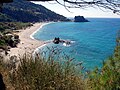
Idyllic beach near Potami

The memorial in honor of Pythagoras in Pythagorio
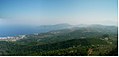
Landscape of Samos


literature
- John Penrose Barron : The Silver Coins of Samos. Athlone Press, London 1966.
- Percy Gardner : Samos and Samian Coins. MacMillan, London 1882, forumancientcoins.com (PDF).
- Ernst Meyer : Samos 2. In: The Little Pauly (KlP). Volume 4, Stuttgart 1972, Sp. 1534-1537 (on ancient history, with further references).
- Wolfram Martini , Cornelius Steckner: The early Byzantine monastery property. The Samos High School. Habelt, Bonn 1993, ISBN 3-7749-2478-3 .
- Andreas Gutsfeld - Stephan Lehmann , Processes of Romanization on Samos in the late Republic (129 BC to 31 BC) , in: Th. G. Schattner / D. Vieweger / D. Wigg-Wolf (eds.) , Continuity and discontinuity, processes of romanization. Case studies between the Iberian Peninsula and the Middle East. (Rahden / Westf. 2019), pp. 71–88.
Web links
- History, maps, historical and current photos, travel information
- SAMOS research of the German Archaeological Institute
Individual evidence
- ↑ Ελληνική Στατιστική Αρχή [ΕΛΣΤΑΤ] (Ed.): Στατιστική Επετηρίδα της Ελλάδος (Statistical Yearbook of Greece) 2009 & 2010 . Piraeus 2011, p. 47 .
- ↑ Παναγιώτης Χρήστου Μούρτζιος: Γεωμορφολογικά και υδρογραφικά χαρακτηριστικά που συνδέονται με την ανάπτυξη των χειμάρρων της νήσου Σάμου (geomorphological and hydrological characteristics connected with the river network revolution in Samos Iceland) . Thessaloniki 2008, p. 47 f . (Greek).
- ↑ a b Map 210 Samos, 1: 50,000 . Road Editions, 2001, ISBN 960-8481-03-1 .
- ↑ a b Map NA 6, Samos - Ikaria, 1: 70,000 . Z-Editions, 2007, ISBN 978-960-6693-12-0 .
- ↑ Καλλιόπη Σταύρου Σταυριανού: Αλλαγές στις χρήσεις γης και στο φυσικό περιβάλλον στη Σάμos Island the 20th century . Στη Σάμos Natural Environment the 20th century . Thessaloniki 2009, p. 15 (Greek).
- ↑ Zaira-Ekaterini Kritikou (Ζαΐρα-Αικατερίνη Κρητικού): Τα αίτια της λειψυδρίας και της πλημμυρογένεσης στα νησιά του βορειοανατολικού Αιγαίου (Ν Λέσβου, Ν Χίου, Ν Σάμου...) (The causes of water-shortage and flood creation in the islands of North Eastern Aegean sea (P. Lesvos, P. Chios, P. Samos)) . Thessaloniki 2005, p. 193 (Greek, phdtheses.ekt.gr p. 72 - Dissertation University of Thessaloniki).
- ↑ National Meteorological Service of Greece, 1955–1997 ( Memento of the original dated December 19, 2011 in the Internet Archive ) Info: The archive link was inserted automatically and has not yet been checked. Please check the original and archive link according to the instructions and then remove this notice.
- ↑ Ζαΐρα-Αικατερίνη Κρητικού p. 73 (Greek)
- ↑ E. Xoplaki, J. Luterbacher, R. Burkard, I. Patrikas, P. Maheras: Connection between the large-scale 500 hPa geopotential height fields and precipitation over Greece during wintertime . In: Climate Research . tape 14 , 2000, pp. 129–146 ( int-res.com [PDF; 3.6 MB ]).
- ↑ Καλλιόπη Σταύρου Σταυριανού, p. 50 f.
- ↑ AP Matzarakis, VD Katsoulis: Sunshine duration hours over the Greek region . In: Theoretical and Applied Climatology . No. 83 . Thessaloniki 2006, p. 107-120 (English).
- ↑ Jeroen Speybroeck, Daniel Bohle, Edoardo Razzetti, Maria Dimaki, Marlene Katharina Kirchner, Wouter Beukema: The distribution of amphibians and reptiles on Samos island (Greece) (Amphibia: Reptilia) . Herpetozoa 27 (1/2), pp. 39-63 online
- ↑ Ourania Kouka: Settlement organization in the North and East Aegean during the Early Bronze Age (3rd millennium BC) . In: International Archeology . tape 58 . Marie Leidorf, Rahden 2002, ISBN 978-3-89646-330-2 , p. 276 ff . (Dissertation, University of Heidelberg 1996).
- ↑ Information about the earthquake in Samos on August 11, 1953. ( Memento of the original from October 4, 2008 in the Internet Archive ) Info: The archive link was inserted automatically and has not yet been checked. Please check the original and archive link according to the instructions and then remove this notice. USGS, accessed July 30, 2008.
- ↑ Giorgos Christides: Refugee crisis in Greece: The forgotten of Samos. In: Spiegel Online . November 9, 2017. Retrieved June 9, 2018 .
- ↑ Samos report Steffen Lüdke, Giorgos Christides, Socrates Baltagiannis (photos): Refugee camp on Samos: "This is our jungle" . In: Spiegel Online . April 18, 2019 ( spiegel.de [accessed May 8, 2019]).
- ↑ Καλλιόπη Σταύρου Σταυριανού p. 65 f. (Greek)
- ↑ Καλλιόπη Σταύρου Σταυριανού, p. 80 (Greek)
- ↑ University of the Aegean (ed.): Η Σημασία του Τουρισμού για την Ελληνική Οικονομία / Κοινωνία & Προτάσεις Πολιτικής για την Τουριστική Ανάπτυξη . Μελέτη Εκπονηθείσα για Λογαριασμό του Συνδέσμου Ελληνικών Τουριστικών Επιχειρήσεων (ΣΕΤΕ) (study on behalf of the Association of Greek Tourism). Chios 2010, p. 102 ff . (Greek, greektourism2020.gr [PDF; 2.7 MB ]). greektourism2020.gr ( Memento of the original from May 16, 2011 in the Internet Archive ) Info: The archive link was inserted automatically and has not yet been checked. Please check the original and archive link according to the instructions and then remove this notice.
- ↑ Samos Marina, Pythagorio (English)
- ↑ KTEL Samou ( Memento of the original from July 12, 2011 in the Internet Archive ) Info: The archive link has been inserted automatically and has not yet been checked. Please check the original and archive link according to the instructions and then remove this notice. (English)
- ^ HJ Kienast: The city wall of Samos . In: Samos , 15, 1978
- ^ HJ Kienast: The water pipe of the Eupalinos on Samos . In: Samos , 19, 1996
- ^ Wolfram Martini : The high school of Samos . (= Samos 16). 1984; Wolfram Martini, Cornelius Steckner : The Samos high school. The early Byzantine monastery property . (= Samos 17). 1993.
Alupka | Alushta | Amastris | Bosporo | Caffa | Harpsichord | Kherson | Chios | Foggia | Yalta | Kilija | Corsica | Monaco | Lesbos | Licostomo | Matrida | Maurocastro | Safi | Salé | Samos | Sardinia | Simesso | Sinope | Smyrna | Sudak | Taman Peninsula | Tana | Thasos | Tmutarakan | Trebizon | Cyprus (Protectorate)