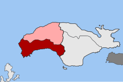
Marathokambos (parish)
|
Marathokambos parish Δημοτική Ενότητα Μαραθοκάμπου (Μαραθόκαμπος) |
||
|---|---|---|
|
|
||
| Basic data | ||
| State : |
|
|
| Region : |
North Aegean
|
|
| Regional District : | Samos | |
| Municipality : | Dytiki Samos | |
| Geographic coordinates : | 37 ° 44 ′ N , 26 ° 40 ′ E | |
| Height above d. M .: | 0–1434 m Aegean Sea - Vigla ( Kerkis ) |
|
| Area : | 87.250 km² | |
| Residents : | 2,609 (2011) | |
| Population density : | 29.9 inhabitants / km² | |
| Code No .: | 560103 | |
| Structure: |
1 city district 4 local communities |
|
| Located in Dytiki Samos Municipality and Samos Regional Unit | ||
The municipality of Marathokambos ( Greek Δημοτική Ενότητα Μαραθοκάμπου Dimotikí Enótita Marathokámbou ) is one of two municipalities in the municipality of Anatoliki Samos on the Greek island of Samos in the North Aegean region . It is subdivided into the municipality of Marathokambos and four local communities.
location
The municipality with the smallest area, at 87,250 square kilometers, is located in the southwest of the island. Adjacent parishes are Karlovasia in the north and Pythagorio in the east.
history
The municipality of Marathokambos was created in 1997 as a result of the municipal reform in 1997 through the merger of five rural municipalities ( Kinotites κοινότητες) that had existed since 1918 . With the administrative reform in 2010 , Marathokambos became part of the municipality of Samos , which encompasses the entire island and in which the former municipality formed the municipality of Marathokambos ( Δημοτική Ενότητα Μαραθοκάμπου Dimotikí Enótita Marathokámbou ). The administrative seat was the small town of the same name Marathokambos . By dividing the island into two municipalities, the municipality of Dytiki Samos was added.
| District local community |
Greek name | code | Area (km²) | 2001 residents | Residents 2011 | Villages and settlements |
|---|---|---|---|---|---|---|
| Marathokambos | Δημοτική Κοινότητα Μαραθοκάμπου | 56010301 | 48.097 | 1960 | 1900 | Marathokambos, Agia Kyriaki , Velanidia, Isomata, Kambos , Limnionas, Ormos Marathokambou , Paleochori, Sevasteika |
| Kallithea | Τοπική Κοινότητα Καλλιθέας | 56010302 | 17.501 | 204 | 136 | Kallithea |
| Koumeika | Τοπική Κοινότητα Κουμαιίκων | 56010303 | 8.725 | 402 | 376 | Koumeika, Velanidia, Ormos Koumeikon |
| Neochori | Τοπική Κοινότητα Νεοχωρίου | 56010304 | 6.575 | 84 | 62 | Neochori |
| Skoureika | Τοπική Κοινότητα Σκουραιίκων | 56010305 | 6.352 | 187 | 135 | Skoureika, Kambos, Perri, Pefkos |
| total | 560103 | 87.250 | 2837 | 2609 | ||
Individual evidence
- ↑ Map 210 Samos, 1: 50,000 . Road Editions, ISBN 978-960-8481-03-9 .
- ↑ Results of the 2011 census, Greek Statistical Office (ΕΛ.ΣΤΑΤ) ( Memento from June 27, 2015 in the Internet Archive ) (Excel document, 2.6 MB)
- ↑ Κεντρική Ένωση Δήμων και Κοινοτήτων Ελλάδας, Ελληνική Εταιρία Τοπικής Ανάπτυξης και Αυτοδιοίκησης (ed.): Λεξικό Διοικητικών Μεταβολών των Δήμων και Κοινοτήτων (1912-2001) . 2 (Τόμος Β, λ – ω). Athens 2002, ISBN 960-7509-47-1 , pp. 82 .

