Pythagorio (municipality)
|
Municipality of Pythagorio Δημοτική Ενότητα Πυθαγορείου (Πυθαγόρειο) |
||
|---|---|---|
|
|
||
| Basic data | ||
| State : |
|
|
| Region : |
North Aegean
|
|
| Regional District : | Samos | |
| Municipality : | Anatoliki Samos | |
| Geographic coordinates : | 37 ° 41 ′ N , 26 ° 57 ′ E | |
| Height above d. M .: | 0-1047 m Aegean Sea - Ambelos |
|
| Area : | 164.662 km² | |
| Residents : | 7,996 (2011) | |
| Population density : | 48.6 inhabitants / km² | |
| Code No .: | 560104 | |
| Structure: |
4 city districts 7 local communities |
|
| Located in Anatoliki Samos Municipality and Samos Regional Unit | ||
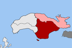
The municipality of Pythagorio ( Greek Δημοτική Ενότητα Πυθαγορείου Dimotikí Enótita Pythagoríou ) is one of two municipalities of the municipality of Anatoliki Samos on the Greek island of Samos in the North Aegean region .
location
With an area of 164,662 square kilometers, Pythagorio is the largest municipality on the island. The municipality is located in the southeast of the island and is subdivided into four urban districts and seven local communities. Adjacent parishes are Vathy in the north and northeast, Karlovasia in the northwest and Marathokambos in the west.
history
Founded in 1918 as the rural municipality of Tigani ( Κοινότητα Τηγανίου Kinótita Tiganíou ) and renamed in 1955, Pythagorio was elevated to a municipal municipality (dimos) in 1989 . Through the amalgamation with ten rural communities ( Kinotites Κοινότητες) that have existed since 1918 as a result of the municipal reform in 1997 , the municipality area increased significantly, from 5.301 to 164.662 square kilometers. The administrative seat was the small town of the same name Pythagorio . With the administrative reform in 2010 , Pythagorio became part of the municipality of Samos , which encompassed the entire island. By dividing the island into two municipalities, the municipality of Pythagorio ( Δημοτική Ενότητα Πυθαγορείου Dimotikí Enótita Pythagoríou ) was added to the municipality of Anatoliki Samos .
| District local community |
Greek name | code | Area (km²) | 2001 residents | Residents 2011 | Villages and settlements |
|---|---|---|---|---|---|---|
| Pythagorio | Δημοτική Κοινότητα Πυθαγορείου | 56010401 | 5.301 | 1642 | 1500 | Pythagorio, Karpovoulos, Nea Poli, Poundes |
| Koumaradei | Τοπική Κοινότητα Κουμαραδαίων | 56010402 | 8,977 | 158 | 130 | Koumaradei |
| Mavratzei | Τοπική Κοινότητα Μαυρατζαίων | 56010403 | 7.977 | 401 | 301 | Mavratzei |
| Mesogio | Τοπική Κοινότητα Μεσογείου | 56010404 | 14.252 | 143 | 109 | Mesogio |
| Myli | Τοπική Κοινότητα Μύλων | 56010405 | 10.503 | 265 | 248 | Myli |
| Mytilinii | Δημοτική Κοινότητα Μυτιληνιών | 56010406 | 34.932 | 2437 | 2107 | Mytilinii, Kamara, Moni Agia Triadas, Potami Mesokambou, Rizovrachos |
| Pagondas | Δημοτική Κοινότητα Παγώνδου | 56010407 | 34.160 | 1294 | 1395 | Pagondas, Ireo , Kolona |
| Pandroso | Τοπική Κοινότητα Πανδρόσου | 56010408 | 10.628 | 166 | 109 | Pandroso |
| Pyrgos | Τοπική Κοινότητα Πύργου | 56010409 | 11.716 | 562 | 419 | Pyrgos |
| Spatharei | Τοπική Κοινότητα Σπαθαραίων | 56010410 | 15.263 | 438 | 337 | Spatharei, Avandi, Apostolos Pavlos, Vergi, Kalogeriko, Kyrgianni, Limnonaki, Metochi, Samiopoula , Sykia |
| Chora | Δημοτική Κοινότητα Χώρας | 56010411 | 10,953 | 1497 | 1340 | Chora, Potokaki |
| total | 560104 | 164.662 | 9003 | 7996 | ||
Individual evidence
- ↑ Map 210 Samos, 1: 50,000 . Road Editions, ISBN 978-960-8481-03-9 .
- ↑ Results of the 2011 census, Greek Statistical Office (ΕΛ.ΣΤΑΤ) ( Memento from June 27, 2015 in the Internet Archive ) (Excel document, 2.6 MB)
- ↑ Τηγάνιον - Πυθαγόρειον, Μετονομασίες των οικισμών της Ελλάδας (Greek)

