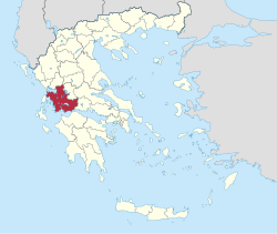
Aetolia-Acarnania
|
Aetolia-Acarnania Regional Unit Περιφερειακή Ενότητα Αιτωλοακαρνανίας (Αιτωλοακαρνανία) |
|
|---|---|
| Basic data | |
| State : | Greece |
| Region : | West Greece |
| Area : | 5,461 km² |
| Residents : | 210,802 (2011) |
| Population density : | 38.6 inhabitants / km² |
| NUTS 3 code no. : | EL631 |
| Structure: | 7 municipalities |
Aetolia-Acarnania ( modern Greek Αιτωλοακαρνανία Etoloakarnania ) is one of the three regional districts of the Greek region of Western Greece . It was established as a prefecture soon after Greece gained independence in 1833, but lost that status in 2011 due to the Greek administrative reform . Apart from the allocation of seats in the regional council, the area no longer has any political significance. The main town is Messolongi . In terms of area, Aetolia-Acarnania was the largest prefecture in Greece in 2010.
geography
Aetolia-Acarnania is located in the southwest of mainland Greece. To the west it is delimited by the coastline of the Ionian Sea . To the north, the Ambracian Gulf forms the border in the western part , in the eastern part the Acheloos river borders the Epirus region . In the northeast, Aetolia-Acarnania borders on the Thessaly region and in the east on the region of Central Greece . The south of the prefecture is formed by the Gulf of Corinth in the eastern part to Andirrio and in the western part by the Gulf of Patras from Andirrio.
The landscape is very diverse. In the southwest, the Acheloos estuary dominates the landscape with a delta through wide plains with lagoons; the most famous, although not directly on the Acheloos, is the Mesolongi lagoon . The Acheloos and its course inland marked the border between the Aetolian landscape (south and east) and the Akarnania landscape (west and north) in antiquity and also today . The Acheloos meanders from Agrinio at the foot of the Panetoliko massif in the east of the prefecture to its confluence with the Ionian Sea at Iniades in a south-westerly direction. The Akarnan Mountains rise north of the Acheloos on the northern edge of its delta mouth. These mountain ranges delimit the Acheloos plain from the southern coast of the Ambracian Gulf . The Ionian island of Lefkada is very close to the mainland off the west coast . The southern coast of the Ambracian Gulf is hilly due to the northern foothills of the Ambracian Mountains. The most important settlement in this area is Vonitsa on the Ambracian Gulf.
The small town of Amfilochia can be found at the southeast tip of the Ambracian Gulf in the Bay of Amfilochia. It marks the beginning of the northern part of the prefecture in the Akarnanien landscape in a mental west-east line . The western foothills of the Pindus Mountains reach here as far as the east coast of the Ambracian Gulf. The northern border of the prefecture is again a plain, which is dominated by the course of a river. Here it is the Arachthos , which, coming from the northeast of Arta, forms the border between Aetolia-Acarnania and Epirus.
In addition to the foothills of the Pindos massif, the east is determined by the chain of reservoirs on the Acheloos. While the highest situated Kremasta Reservoir only bordered on the Aetolia-Acarnania Prefecture, the Kastraki Reservoir and the Stratos Reservoir are located entirely in the Aetolia-Acarnania area. To the southeast, the Panetoliko massif delimits the Aetolian plain, which is largely determined by the largest lake in Greece: Lake Trichonida . North of the western end of Lake Trichonida is the largest city of Aetolia-Akarnania: Agrinio . Lysimachia Lake is adjacent . To the south of this begins the Etoliko lagoon with the city of the same name . It passes into the Mesolongi lagoon.
The south-east of the area is determined in its north by the plain extending to the east into the mountains with Lake Trichomida in the northern part. Further to the southeast, the Nafpaktia Mountains separated the plain of Lake Trichonida from the coast of the Gulf of Patras . Cape Andirrio, with Cape Rio and the resulting strait of Rio-Andirrio, separates the Gulf of Patras in the west from the Gulf of Corinth in the east. The Nafpaktia Mountains pull east past this cape and frame the city of Nafpaktos on the north coast of the western Gulf of Corinth. The mountains of Nafpaktias are separated from the Aetolian plain around Messolongi by the Evinos river or cut through in the upper reaches. To the east, the mountains of Nafpaktias merge into the mountains of Fokida and further into the southern foothills of the Pindos massif.
structure
Aetolia-Acarnania includes the municipalities of Agrinio , Aktio-Vonitsa , Amfilochia , Mesolongi , Nafpaktia , Thermo and Xiromero .
Web links
- Aerial photos of the prefecture (description in Greek).
Individual evidence
- ↑ Results of the 2011 census at the National Statistical Service of Greece (ΕΛ.ΣΤΑΤ) ( Memento from June 27, 2015 in the Internet Archive ) (Excel document, 2.6 MB)
