
Achaia
|
Achaia regional unit Περιφερειακή Ενότητα Αχαΐας (Αχαΐα) |
|
|---|---|
 |
|
| Basic data | |
| State : | Greece |
| Region : | West Greece |
| Area : | 3,209 km² |
| Residents : | 309,694 (2011) |
| Population density : | 96.5 inhabitants / km² |
| NUTS 3 code no. : | EL632 |
| Structure: | 5 municipalities |
Achaia ( modern Greek Αχαΐα , also Achäa ) is a landscape in the north-western Peloponnese and one of the three regional districts of the Greek region of western Greece . Achaia was established as a prefecture from the division of the prefecture Achaia and Elis, which had existed since 1833 , but lost this status with the administrative reform in 2010 . As a regional council, Achaia has no political significance apart from the allocation of seats in the regional council. The center of the area is the city of Patras with 171,484 inhabitants.
Achaia includes the communities of Dytiki Achaia , Egialia , Erymanthos , Kalavryta and Patras.
The Achaeans or Achaeans were one of the main tribes of ancient Greece . They also colonized the phthiotis . Homer uses the term Achaeans - next to Danaer and Argiver - for the Greeks fighting against Troy per se.
The ancient landscape stretched on the north coast of the Peloponnese from Cape Avgo in the east to Cape Araxos in the west. Later Achaia was part and namesake of the Roman province of Achaea .
Until 1943, Megaspiläon (Greek Μεγα Σπήλαιον, large cave ') was the largest and richest monastery in Greece.
photos

The Rio-Andirrio Bridge connects Achaia with Aetolia-Acarnania

In the port of Patras

The Achaia Clauss winery

Memorial for the massacre of the German Wehrmacht in Kalavryta in 1943

At Ano Lousi, north of Kastria, Achaia
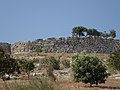
Mycenaean fortification Teichos Dymaion


Individual evidence
- ↑ Results of the 2011 census at the National Statistical Service of Greece (ΕΛ.ΣΤΑΤ) ( Memento from June 27, 2015 in the Internet Archive ) (Excel document, 2.6 MB)
Achaia | Argolis | Arcadia | Arta | Athens | Aetolia-Acarnania | Boiotia | Halkidiki | Chania | Chios | Dodecanese | Drama | Elis | Euboea | Evrytania | Evros | Florina | Fokida | Fthiotida | Grevena | Imathia | Ioannina | Heraklion | Karditsa | Kastoria | Kavala | Kefallinia | Kilkis | Kerkyra | Corinthia | Kozani | Cyclades | Laconia | Larisa | Lasithi | Lefkada | Lesbos | Magnesia | Messenia | Pella | Ostattika | Pieria | Piraeus | Preveza | Rethymno | Rodopi | Samos | Serres | Thesprotia | Thessaloniki | Trikala | West Attica | Xanthi | Zakynthos
Coordinates: 38 ° 5 ' N , 21 ° 52' E