Laconia
|
Laconia Regional Unit Περιφερειακή Ενότητα Λακωνίας (Λακωνία) |
|
|---|---|
| Basic data | |
| State : | Greece |
| Region : | Peloponnese |
| Area : | 3,636 km² |
| Residents : | 89,138 (2011) |
| Population density : | 24.5 inhabitants / km² |
| NUTS 3 code no. : | - |
| Structure: | 5 municipalities |
| Website: | www.lakonia.gr |
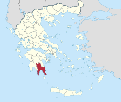
Laconia ( Greek Λακωνία Lakonía ) is a Greek landscape in the south of the Peloponnese region .
Laconia was also the name of the Spartan state in antiquity, whose free inhabitants were called Laconians or Lacedaemonians . The expression laconic speech is derived from the adjective laconic as a designation for the Spartans (cf. Spartan ) .
After the founding of the modern state of Greece in 1833, Laconia was established as a prefecture and remained that way with a few interruptions until the administrative reform in 2010 . In doing so, their competencies were transferred to the municipalities, which had been greatly reduced by amalgamation, and the Peloponnese region . Since then Laconia forms the regional district Laconia (gr. Periferiaki Enotita Lakonias ). This sends eight members to the regional council of the Peloponnese region , but has no further political significance. Laconia includes the municipalities of Anatoliki Mani , Elafonisos , Evrotas , Monemvasia and Sparta .
geography
Laconia is located between the Parnon and Taygetos mountains, high mountain ranges that usually exceed the thousand-meter limit and thus made the entire region a fortress in ancient times. The mountain ranges run out in two “fingers” of the Peloponnese peninsula , the Parnon at the end of a rather low chain of karst hills in Cape Kremidi, the Taygetos in the Mani peninsula . Between them there is the Laconic Gulf and the fertile valley of the Evrotas River , which, until it reaches the Laconic Gulf after about 70 km, is supplemented by numerous tributaries, which ensure uniform irrigation throughout the valley.
Only sparse archaeological remains have been preserved from the ancient capital, Sparta . The Byzantine ruined city of Mystras and the stalactite cave of Diros in West Mani are among the most famous tourist destinations in the prefecture .
Former provinces (επαρχίες)
When Laconia was founded, the area consisted of the provinces
- Epidavros Limiras (Επίδαυρος Λιμήρας), capital of Molai
- Lacedaemon (Λακεδαίμων), capital of Sparta
- Gythio (Γύθειο), main town Gythio
- Itylo (Οίτυλο), main town Areopoli
At times, namely from 1836 to 1845 and from 1899 to 1909, Laconia was divided into two areas, namely Laconia with the provinces of Gythio and Itylo (from 1899 to 1909 as Lakoniki Prefecture ) and Laconia in the narrower sense, which included the Provinces of Lacedaimon and Epidavros Limiras included. The province of Kythira belonged to the prefecture of Lakonia or Lakoniki from 1866 to 1909.
Web links
in German:
- http://www.vatika.de/
- http://www.leonidion.de/lakonien.htm
- Information about the Laconian Gulf on SkipperGuide.de
- History and geography of Laconia
in English:
in Greek:
- Cities and Towns of Laconia
- Map with administrative division ( Memento from February 17, 2013 in the web archive archive.today )
Individual evidence
- ↑ Results of the 2011 census at the National Statistical Service of Greece (ΕΛ.ΣΤΑΤ) ( Memento from June 27, 2015 in the Internet Archive ) (Excel document, 2.6 MB)
