
Karditsa (regional unit)
|
Karditsa Regional Unit Περιφερειακή Ενότητα Καρδίτσας (Καρδίτσα) |
|
|---|---|
 |
|
| Basic data | |
| State : | Greece |
| Region : | Thessaly |
| Area : | 2,636 km² |
| Residents : | 113,544 (2011) |
| Population density : | 43.1 inhabitants / km² |
| NUTS 3 code no. : | - |
| Structure: | 5 municipalities |
The regional district of Karditsa ( Greek Periferiaki Einotita Karditsas ) is one of the five regional districts of the Greek administrative region of Thessaly with its seat in the city of Karditsa . Until the Greek administrative reform in 2010 , the area around the main town Karditsa had the status of a prefecture . In the meantime, their competencies have been transferred to the region and the newly formed municipalities; the regional district sends nine members to the regional council of Hessen, but has no further political significance as a regional authority. Karditsa includes the parishes of Argithea , Karditsa , Limni Plastira , Mouzaki , Palamas and Sofades .
geography
Geographically or geomorphological regional district is divided into two parts: In the west, southwest and south will find the eastern foothills of the Pindos -Massivs, the northwest, north, northeast, east and southeast part of the hilly transition to the plain of Thessaly. The western border is formed by the Acheloos river shortly before its damming up to the Kremasta reservoir . In the mountainous west west-southwest of the city of Karditsa is the Plastiras Lake (also called Tavropos Lake), which was created by the damming of the Tavropos (Megdova) river in the 1960s. To the west, south-west and south of Lake Plastira are the Agrafa Mountains on the border with Evrytania . The highest point of the regional district is in the west of the Plastira lake in the aforementioned mountains: the Karava (or Karava Agrafon) with a maximum height of 2184 m . The entire west of the area is high mountain.
In the south the mountains of the Pindus massif are flatter; Here maximum heights of 1021- to 1447 m achieved. To the east, the south flattens out to the massif of Narthakio , which has its southeastern continuation in the massifs of Gouras and Othris .
The city of Karditsa lies in the middle of the prefecture area and has the foothills of the Pindos massif in its west; to the east, north-east, north and south-east, the Thessalian plain opens up after a hilly transition.
traffic
In the Karditsa area, road traffic is by far the main mode of transport for both private and commercial individual traffic. Local public transport is also mainly handled by KTEL buses.
Street
The national road 30 , coming from the north-west from Trikala, first leads to Karditsa, where it turns east-south-east and continues via Sofades , Farsala , Neo Monastiri, Nea Anichialos to Volos in the east. There are no efficient east-west connections - especially to west Greece and south Epirus. The road from Karditsa to Arta in the west via Mavromati, Mouzaki, Oxia across the Pindos massif is winding and narrow. It is not safely passable in winter. The north-south connections are guaranteed by the national road 30, but the road connection to Karpenissi in Evrytania is also not efficient due to its very winding route and the state of development.
In the coming years, the north-south connections in the road network in particular are to be significantly improved through the construction of Autobahn 3 . Motorway 3 will connect Motorway 1 ( Athens - Thessaloniki ) near Lamia (Greece) with Motorway 2 between Metsovo and Grevena . The route runs through the prefecture of Karditsa and the agglomeration of Karditsa.
railroad
Karditsa has a transport hub on the Greek railway network in the village of Stavros . There, the main axis of the Greek railway from Thessaloniki in the north via Lamia to Athens in the south crosses with the railway line from Volos in the east via Farsala , Karditsa , Trikala to Kalambaka . The main traffic axis is currently being expanded to the level of high-speed trains, whereby the passage on the western flank of the Othris Mountains continues to consist of a real pass ascent. An underground tunnel from Domokos to Lianokladi is supposed to remedy this: the financing of this large tunnel is currently not clear.

View of the Plastiras lake in the east of the district
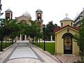
A church in the city of Karditsa


Web links
- Aerial photos of the prefecture (description in Greek).
Individual evidence
- ↑ Results of the 2011 census at the National Statistical Service of Greece (ΕΛ.ΣΤΑΤ) ( Memento from June 27, 2015 in the Internet Archive ) (Excel document, 2.6 MB)
Achaia | Argolis | Arcadia | Arta | Athens | Aetolia-Acarnania | Boiotia | Halkidiki | Chania | Chios | Dodecanese | Drama | Elis | Euboea | Evrytania | Evros | Florina | Fokida | Fthiotida | Grevena | Imathia | Ioannina | Heraklion | Karditsa | Kastoria | Kavala | Kefallinia | Kilkis | Kerkyra | Corinthia | Kozani | Cyclades | Laconia | Larisa | Lasithi | Lefkada | Lesbos | Magnesia | Messenia | Pella | Ostattika | Pieria | Piraeus | Preveza | Rethymno | Rodopi | Samos | Serres | Thesprotia | Thessaloniki | Trikala | West Attica | Xanthi | Zakynthos