
Limni Plastira (Municipality)
|
Limni Plastira municipality Δήμος Λίμνης Πλαστήρα (Λίμνη Πλαστήρα) |
|||
|---|---|---|---|
|
|||
| Basic data | |||
| State : |
|
||
| Region : | Thessaly | ||
| Regional District : | Karditsa | ||
| Geographic coordinates : | 39 ° 18 ′ N , 21 ° 45 ′ E | ||
| Area : | 195.16 km² | ||
| Residents : | 4,635 (2011) | ||
| Population density : | 23.7 inhabitants / km² | ||
| Seat: | Morfovouni | ||
| LAU-1 code no .: | 2303 | ||
| Districts : | 2 parishes | ||
| Local self-government : | 12 local communities | ||
| Location in the Thessaly region | |||
 |
|||

Limni Plastira ( Greek Λίμνη Πλαστήρα ( f. Sg. ) 'Plastiras Lake') is a municipality on the banks of the reservoir of the same name in the south of the Greek region of Thessaly . It is based in the town of Morfovouni (485 inhabitants), where the Greek general and politician Nikolaos Plastiras was born in 1883 , who gave both the lake and the municipality its name.
geography

The municipality is located on the eastern slope of the Voutsikaki massif ( 2154 m ), which belongs to the northern Agrafa Mountains. Argithea is the neighboring municipality to the west in the mountains . The headwaters of the Tavropos , which flowed together in a valley in the center of the municipality, has been dammed up since 1962 to form the Plastiras lake , which is mostly in the municipality and divides it into two parts; the dam itself connects Limni Plastira with the eastern neighboring municipality of Karditsa . To the south, the central Greek municipality of Agrafa borders the municipality. The area around the lake, which is around 750 m above sea level, is significantly more mountainous in the south than in the northeast, the mountains drop east of the lake to the east behind a chain of hills in a prominent terrain to the Thessalian plain. The lowest point of the municipality is east of the small town of Razia at around 120 m above sea level. The north of the municipality slopes north of the village Kerasia with the brook Kerasiotikos to the north to the catchment area of the Pamisos and thus the Pinios . This is where the community of Mouzaki joins.

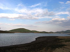
View from the north on Belokomiti

At Belokomiti
In the north of the municipality


Church history
The border with the Ottoman Empire ran through today's municipal area after the establishment of Greece until the annexation of Thessaly in 1881 . The southern places Karitsa and Belokomiti already belonged to Greece and were united in a short-lived municipality of Ellopia (1836), then in the municipality of Ktimenia. From Ktimenia, among other things, with these villages, a 'township of the Doloper ' was spun off in 1877 (Gr. Dimos Dolopon Δήμος Δολόπων, the Doloper were one of the Thessalian tribes that settled in the mountains). Karvasaras was recognized as a settlement of this municipality in 1877. Lambero belonged to the neighboring municipality of Itamos to the east. In 1883 the municipality of Nevropolis was founded on the Thessalian side with its seat in Mesenikolas, into which the northern villages of the municipality as well as Portitsa and Agios Georgios (today to Karditsa) were incorporated. In 1912, the communities were split into individual small rural communities. In 1974 a new demarcation took place between the prefectures Evrytania and Karditsa, and the rural communities Karitsa and Belokomiti came to the prefecture of Karditsa and thus to the later region of Thessaly. During the municipal reorganization in 1997, the municipalities Nevropoli Agrafon (west of the now existing reservoir) and Plastiras (north and east of the lake) were created. These two communities were merged in 2010 and the new community was named after the lake.
As in all of Greece, some villages in the Limni Plastira area were renamed during the 20th century:
| Today's name | Greek | old name | Greek | to |
|---|---|---|---|---|
| Agia Marina | Αγία Μαρίνα | Plakoto | Πλακωτό | 1997 |
| Belokomiti | Μπελοκομίτη | Bilokomiti | Μπιλοκομήτι | 1940 |
| Fylakti | Φυλακτή | Sermeniko | Σερμενίκο | 1928 |
| Kedros | Κέδρος | Chalambresi | Χαλαμπρέζι | 1928 |
| Lambero | Λαμπερό | Titagi | Τιτάγι | 1928 |
| Morfovouni | Μορφοβούνι | Vounesi | Βούνεσι | 1928 |
| Moschato | Μοσχάτο | Blasdo Koroni |
Μπλάσδο Κορώνη |
1957 1958 |
| Neraida | Νεράϊδα | Spinasa | Σπινάσα | 1928 |
| Pezoula | Πεζούλα | Bezoula Agios Serafim |
Μπεζούλα Άγιος Σεραφείμ |
1972 1976 |
| Petroto | Πετρωτό | Choliano | Χόλιανο | 1962 |
| Kryoneri | Κρυονέρι | Stougo | Στούγκο | 1927 |
Community structure
The 12 municipalities that existed until 1997 have had the status of local communities (topiki kinotita) since 2011 and elect a council or an individual representative as local representation, depending on the number of inhabitants. The population figures come from the results of the 2011 census.
- Municipality of Nevropoli Agrafon - Δημοτική Ενότητα Νεβρόπολης Αγράφων - Νεβρόπολη Αγράφων - 2.223
- Local community Belokomiti - Τοπική Κοινότητα Μπελοκομίτης - 178
- Belokomiti - Μπελοκομίτη - 146
- Kedros - Κέδρος - 32
- Local community Fylakti - Τοπική Κοινότητα Φυλακτής - 332
- Fylakti - Φυλακτή - 278
- Kalyvia Fylaktis - Καλύβια Φυλακτής - 54
- Local community Karitsa Dolopon - Τοπική Κοινότητα Καρίτσης Δολόπων - 134
- Agia Marina - Αγία Μαρίνα - 44
- Agia Paraskevi - Αγία Παρασκευή - 6
- Karitsa - Καρίτσα - 56
- Longa - Λογγά - 4
- Mega Revma - Μέγα Ρεύμα - 5
- Petroto - Πετρωτό - 1
- Rafina - Ραφήνα - 18th
- Local community Karvasaras - Τοπική Κοινότητα Καρβασαρά - Καρβασαράς - 28
- Local community Kryoneri - Τοπική Κοινότητα Κρυονερίου - 595
- Koutsodimos - Κουτσοδήμος - 78
- Kryoneri - Κρυονέρι - 415
- Prosilia - Προσήλια - 102
- Local community Neochori - Τοπική Κοινότητα Νεοχωρίου - Νεοχώρι - 589
- Local community Pezoula - Τοπική Κοινότητα Πεζούλας - 367
- Kalyvia - Καλύβια - 223
- Neraida - Νεράιδα - 17th
- Pezoula - Πεζούλα - 127
- Local community Belokomiti - Τοπική Κοινότητα Μπελοκομίτης - 178
- Municipality of Plastiras - Δημοτική Ενότητα Πλαστήρα - Πλαστήρας - 2,412
- Local community Kerasia - Τοπική Κοινότητα Κερασέας - 390
- Kerasia - Κερασέα - 299
- Nevropoli - Νεβρόπολη - 91
- Local community Lambero - Τοπική Κοινότητα Λαμπερού - 559
- Agios Athanasios - Άγιος Αθανάσιος - 324
- Lambero - Λαμπερό - 235
- Local community Mesenikolas - Τοπική Κοινότητα Μεσενικόλα - 459
- Mesenikolas - Μεσενικόλας - 451
- Moni Koronis - Μονή Κορώνης - 8
- Local community Morfovouni - Τοπική Κοινότητα Μορφοβουνίου - 576
- Morfovouni - Μορφοβούνι - 485
- Razia - Ράζια - 55
- Rachovitsa - Ραχωβίτσα - 36
- Local community Moschato - Τοπική Κοινότητα Μοσχάτου - 428
- Agios Nikolaos - Άγιος Νικόλαος - 42
- Moschato - Μοσχάτο - 378
- Tsardaki - Τσαρδάκι - 8
- Local community Kerasia - Τοπική Κοινότητα Κερασέας - 390
Individual evidence
- ↑ a b Results of the 2011 census at the National Statistical Service of Greece (ΕΛ.ΣΤΑΤ) ( Memento from June 27, 2015 in the Internet Archive ) (Excel document, 2.6 MB)
- ↑ a b Renaming and administrative history of the database of the EETAA (Greek Society for Development and Decentralization) ( Memento of the original from October 16, 2013 in the Internet Archive ) Info: The archive link was inserted automatically and has not yet been checked. Please check the original and archive link according to the instructions and then remove this notice.