
Plastiras reservoir
| Plastiras reservoir | |||||
|---|---|---|---|---|---|
 |
|||||
|
|||||
|
|||||
| Coordinates | 39 ° 17 '50 " N , 21 ° 45' 9" E | ||||
| Data on the structure | |||||
| Construction time: | 1958–1962 | ||||
| Height of the barrier structure : | 83 m | ||||
| Crown length: | approx. 200 m | ||||
| Power plant output: | 130 MW | ||||
| Data on the reservoir | |||||
| Water surface | 22,180 km² | ||||
| Reservoir length | 13,760 km | ||||
| Reservoir width | 4,330 km | ||||

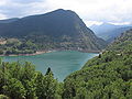
The Plastiras Reservoir ( Greek τεχνητή λίμνη Πλαστήρα techniti limni Plastira ) is a reservoir in Greece . The reservoir is located in Thessaly and is in the Karditsa regional district . The area covers 22,180 km², the north-south extension (length) is 13,760 km and the maximum width 4,330 km. The reservoir is primarily used as a water reservoir and to generate electrical energy. Today the reservoir is also used for tourism (bathing beaches and boating), but the strongly fluctuating water level makes these efforts difficult.
Dam wall
The dam is at the southern end of the lake. It was built from 1958 to 1962 and - like the lake itself - is named after the Greek Prime Minister Nikolaos Plastiras . The dam of the Plastiras reservoir is 83 m high and approx. 200 m wide. A single-lane, freely passable road leads over the top of the wall (two-way traffic area with traffic lights).
Geographical location
The landscape surrounding the lake is divided into two different characters. The dominant narrow valley landscape gives the southern section immediately near the dam a fjord-like appearance. In the northern part of the lake basin, on the other hand, the bank slopes gently towards the water, the landscape appears spacious. The lake is delimited in the west by the foothills of the Pindus Mountains , in the east the landscape falls behind a chain of hills in a striking terrain down to the Thessalian plain. The lake is fed by many smaller tributaries that arise in the Pindos Mountains to the west of the lake. The river Tavropos emerges from the lake , which in turn forms a tributary of the Kremasta reservoir .
colonization
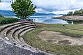
Naturally, there are no historical settlements directly on the banks of the reservoir, only in the village of Kalibia there is a cul-de-sac with beaches and a few newly built buildings. There is a ring road around the lake that opens up all places in the vicinity of the lake. Larger places are Morfovouni and Kerasea in the north of the lake, Kalibia and Neochori in the west and Kastani in the south. In addition to the villages, there are two monasteries in the vicinity of the lake, the Korona monastery in the east of the lake near Morfovouni and the Pelikitis monastery in the west. The latter is high above the lake with a view of the southern part of the lake. Both monasteries can be reached on an asphalt road.
View to the dam

the fjord-like section in the southern part

the extensive section in the northern part
Lake at Plaz Lamperou


.jpg)