Tavropos
|
Tavropos or Megdovas (Ταυρώπος η Μέγδοβας) |
||
|
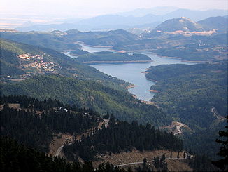
View of the Tavropos reservoir (Plastira lake) on the upper reaches of the Tavropos (Megdovas). |
||
| Data | ||
| location | Greece , Thessaly ( Karditsa ) and Central Greece ( Evrytania ) | |
| River system | Acheloos | |
| Drain over | Acheloos → Ionian Sea | |
| source |
Northeast Agrafa Mountains ( Plastiras Reservoir ) 39 ° 14 ′ 9 ″ N , 21 ° 44 ′ 45 ″ E |
|
| Source height | 1600 m | |
| muzzle |
Kremasta Lake ( Acheloos ) Coordinates: 38 ° 53 ′ 34 " N , 21 ° 38 ′ 17" E 38 ° 53 ′ 34 " N , 21 ° 38 ′ 17" E
|
|
| length | 60-78 km | |
| Left tributaries | Karitsiotis , Ozoula , Aspros , Lesioti , Gavrenitis | |
| Right tributaries | Mouchthouri , Mega , Agiotriaditiko , Stenomatiotiko | |
| Small towns | Kryoneri , Anthiro Neraida , Dafni , Viniani , Nea Viniani | |
The Tavropos ( Greek Ταυρώπος ; alternative name Megdovas , Μέγδοβας or Megdova , Μέγδοβα ) is a 60 to 78 km long river, depending on the source, in the regional districts of Karditsa ( Thessaly region ) and Evrytania ( Central Greece region ) in Greece. It flows from its headwaters , which has been redesigned by the Plastiras reservoir , in the northeastern Agrafa Mountains to the south to the Acheloos , which was dammed up to become the Kremasta Lake .
The Tavropos before the damming of the Plastiras lake was fed by the source rivers Kerasiotiko (flows into the northwest corner of the Plastiras lake), Megalo (flows into the west coast of the Plastiras lake at Kalivia Pezoulas) and Karditsiotis, which at the southwest corner of the Plastiras Lake flows into this just north of the dam (near Belokomti). The longitudinal axis of the Plastiras lake corresponds to the course of the Tavropos from north to south.
The Tavropos after the damming of the Plastiras lake begins at the dam of the lake southeast of Kedros and west of Moucha. The south-facing valley between the mountains Petalouda (1,770 m) in the west and Pyrgouli (1,246 m) in the east leads the Tavropos to its first tributary after the Plastiras lake from the west, the Ozoula. This opens at Agios Georgios convent in the Tavropos and widens the valley in a mountainous for the ratios of the Agrafa Mountains to a large level (Megas Kambos). The Tavropos swings slightly to the south-southeast and reaches the village of Anthiro on its western bank. At the level of the village, the Tavropos receives a small tributary from the east. A little further south, near the village of Agia Agathi and northeast of Karoplesi, the Aspro tributary meets the Tavropos. This continues its course unchanged to the south-southeast between the mountains Valaora (1,300 m) in the east and Papadimitri (1,930 m) and Voidolivado (1,540 m) in the west. The tributary Mouchthouri flows from the east between the village of Koukaika on the left bank and the larger town of Neraida on the right bank, which in turn receives a tributary from the Sarandaporos river further east. Between the Voidolivado mountain in the northwest and the Martsa mountain (1,687 m) in the east, the Tavropos swings after the confluence of the Mouchthouri to the south-southwest and meets exactly west of the Martsa summit and just south of the Voidolivado on the Lesioti river, which comes from the west opens into the Tavropos.
The Lesioti marks the border between the regions of Thessaly and Central Greece. Thus, the Tavropos crosses this border in its course and flows from this position in a southerly direction into the regional district of Evrytania. East of the Xerovouni mountain (1,334 m), the Mega flows into the Tavropos from the villages of Mesochori and Platanos. This then changes its direction a little and flows with increasing meanders in a western arc around the mountain range with the peaks Lelouli (1,344 m), Spanos (1,411 m), Kombolos (1,440 m) and the Afti summit (971 m) protruding to the west ) around. West of the Tavropos at the height of the Afti summit is the village of Mavromata, which lies amphitheatrically in a basin between Profitis Ilias (1,302 m) and Kopsi (1,939 m).
To the southwest of Profitis Ilias and northwest of the village of Domiani, the Agiotriadiko river flows into the Tavropos from the southeast. The Agiotriadiko forms the north-eastern limit of the Tymfristos . After this confluence, the Tavropos swings abruptly to the west, leads south along the Profitis Ilias to the village of Dafni on the western bank and thus marks the north-western boundary of the Tymfristos. At Dafni the Tavropos swings again to the south-west and receives the Stenomatiotiko tributary coming from the east-south-east from the village of Stenoma shortly before the village of Viniani, which rises on the western flank of the Tymfristos. After passing Viniani and Nea Viniani on the western bank of the river with the Tymfristos massif on the eastern bank, the Tavropos is crossed by a bridge from the national road 38 ( Karpenisi - Agrinio ). At the level of the village of Dytiko Paparousi, the Tavropos widens to the easternmost foothills of Lake Kremasta. The transition between Tavropos and Kremasta Lake depends heavily on the water level of the lake and can consequently shift a few kilometers to the northeast (high water) or southwest (low water).
swell
- Άγραφα / Mt. Agrafa Map. 1: 50,000. Road Editions, Athens. ISBN 960-8481-99-6
