Tembi (municipality)
|
Tembi municipality Δήμος Τεμπών |
||
|---|---|---|
|
|
||
| Basic data | ||
| State : |
|
|
| Region : | Thessaly | |
| Regional District : | Larisa | |
| Geographic coordinates : | 39 ° 48 ′ N , 22 ° 30 ′ E | |
| Area : | 576.95 km² | |
| Residents : | 13.712 () | |
| Population density : | 23.8 inhabitants / km² | |
| Seat: | Makrychori | |
| LAU-1 code no .: | 2205 | |
| Districts : | 5 municipal districts | |
| Local self-government : |
1 city district 17 local communities |
|
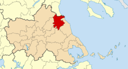
| Location in the Thessaly region | ||
Tembi ( Greek Τέμπη Tembi ( n. Pl. ) Or Dimos Tembon Δήμος Τεμπών) is a municipality in Greece .
geography
Geographical location
Tembi is located in northern Thessaly on the southern slope of Olympus , the highest Greek mountain. It was newly created in 2010 from five previous municipalities. The municipal administration is based in the small town of Makrychori . Tembi was named after the Tempe valley , which lies in the municipality and separates the Olympus massif from that of Ossa to the south .
Community structure
The population figures come from the results of the 2011 census; the municipal districts correspond to the municipalities that existed from 1997 to 2010.
- Ambelakia municipality (δημοτική ενότητα Αμπελακίων) - 510 inhabitants
- Local community Ambelakia (Αμπελάκια) - 434 Ew.
- Local community Tembi (Τέμπη) - 76 Ew.
- Gonni municipality (δημοτική ενότητα Γόννων) - 3,119 inhabitants
- District Gonni - 2.288 Ew.
- Elea (Ελαία) - 98 Ew.
- Gonni (Γόννοι) - 2.190 Ew.
- Local community Itea (Ιτέα) - 291 Ew.
- Local community Kallipefki (Καλλιπεύκη) - 540 Ew.
- District Gonni - 2.288 Ew.
- Municipality of Kato Olymbos (δημοτική ενότητα Κάτω Ολύμπου, 'Lower Olympus') - 3,496 inhabitants
- Local community Pyrgetos (Πυργετός) - 1.463 Ew.
- Local community Egani - 1.134 Ew.
- Egani (Αιγάνη) - 535 Ew.
- Kato Egani (Κάτω Αιγάνη) - 98 Ew.
- Kastri Loutro - Καστρί Λουτρό - 110 Ew.
- Nea Mesangala (Νέα Μεσάγκαλα) - 388 Ew.
- Parapouli (Παπαπούλι) - 3 Ew.
- Local community Kranea - 212 Ew.
- Kranea (Κρανέα) - 107 Ew.
- Kouloura (Κουλούρα) - 88 Ew.
- Mathitikes Kataskinosis - Μαθητικές Κατασκηνώσεις - uninhabited
- Paralia Koulouras (Παραλία Κουλούρας) - 17 Ew.
- Local community Rapsani - 687 Ew.
- Agios Konstandinos (Άγιος Κωνσταντίνος) - 13 Ew.
- Perataria (Περαταριά) - 119 Ew.
- Rapsani (Ραψάνη) - 555 Ew.
- Makrychori Municipality (δημοτική ενότητα Μακρυχωρίου) - 2,553 inhabitants
- Local community Elatia - 492 Ew.
- Local community Evangelismo Larisis (Ευαγγελισμός Λαρίσης) - 178 Ew.
- Local community Makrychori - 1,689 Ew.
- Gyrtoni (Γυρτώνη) - 74 Ew.
- Makrychori (Μακρυχώρι) - 1.615 Ew.
- Local community Parapotamos (Παραπόταμος) - 245 Ew.
- Nessonas municipality (δημοτική ενότητα Νέσσωνος) - 4,750 inhabitants
- District Sykouri - 2.316 Ew.
- Local community Kalochori - 2.316 Ew.
- Chimadio (Χειμάδιο) - 213 Ew.
- Kalochori (Καλοχώρι) - 543.
- Local community Kypselochori - 182 Ew.
- Akrino - Ακρινό - uninhabited
- Kypselochori - Κυψελοχώρι - 183 Ew.
- Local community Nessonas (Νέσσωνας) - 94 Ew.
- Korakas - Κόρακας - uninhabited
- Nessonas - Νέσσωνας - 94 Ew.
- Local community Ossa (Όσσα) - 530 Ew.
- Local community Pournari (Πουρνάρι) - 502 Ew.
- Local community Spilia (Σπηλιά) - 370 Ew.
traffic
The Piraeus – Thessaloniki railway runs across the municipality . There were a number of train stations here : Gyrtoni , Evangelismos , Tembi , Agia Paraskevi and Rapsani , of which only Rapsani is served today.
Individual evidence
- ↑ a b Results of the 2011 census. ( Memento from June 27, 2015 in the Internet Archive ) ( MS Excel ; 2.6 MB) National Statistical Service of Greece (ΕΛ.ΣΤΑΤ)

