Almyros
|
Almyros municipality Δήμος Αλμυρού (Αλμυρός) |
||
|---|---|---|
|
|
||
| Basic data | ||
| State : |
|
|
| Region : | Thessaly | |
| Regional District : | Magnesia | |
| Geographic coordinates : | 39 ° 8 ' N , 22 ° 43' E | |
| Area : | 905.364 km² | |
| Residents : | 18,614 (2011) | |
| Population density : | 20.6 inhabitants / km² | |
| Seat: | Almyros | |
| LAU-1 code no .: | 2402 | |
| Districts : | 4 municipal districts | |
| Local self-government : |
3 city districts 15 local communities |
|
| Website: | www.almyros-city.gr | |
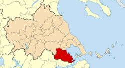
| Location in the Thessaly region | ||
Almyros ( Greek Αλμυρός ) is a municipality in the southeast of the Greek region of Thessaly . The administrative seat of the municipality is the small town of Almyros.
The municipal area is almost identical to the former province of Almyrou ( Επαρχία Αλμυρού Eparchía Almyroú ).
location
The municipality of Almyros is located in the southeast of Thessaly on the west coast of the Pagasitic Gulf . In the south and southwest, the Othrys Mountains form the border with Central Greece . Neighboring communities in Thessaly are Volos and Rigas Fereos in the north and Farsala in the northwest. The Central Greek communities Domokos and Stylida border in the west and south.
Administrative division
The municipality was formed after the administrative reform in 2010 from the merger of the former municipalities Almyros , Pteleos and Sourpi as well as the rural municipality of Anavra . The administrative seat of the municipality is the town of the same name, Almyros. The former municipalities have since formed municipal districts. The community is further subdivided into 3 city districts and 15 local communities.
| Parish | Greek name | code | Area (km²) | Residents 2011 | City districts / local communities (Δημοτική / Τοπική Κοινότητα) |
location |
|---|---|---|---|---|---|---|
| Almyros | Δημοτική Ενότητα Αλμυρού | 240201 | 473,940 | 12,678 | Almyros, Anthotopos, Efxinoupoli, Kokkoti, Krokio, Kofi, Platanos, Fylaki | |
| Anavra | Δημοτική Ενότητα Ανάβρας | 240202 | 121.859 | 584 | Anavra | |
| Pteleus | Δημοτική Ενότητα Πτελεού | 240203 | 118.230 | 2,485 | Agii Theodori, Achillio, Pteleos | |
| Sourpi | Δημοτική Ενότητα Σούρπης | 240204 | 191,335 | 2,867 | Sourpi, Agia Trias, Agios Ioannis, Amaliapoli, Vrynena, Drymonas | |
| total | 2402 | 905,364 | 18,614 | |||
Individual evidence
- ↑ Results of the 2011 census at the National Statistical Service of Greece (ΕΛ.ΣΤΑΤ) (Excel document, 2.6 MB)
- ↑ Kallikratis Program, Law 3852/2010, «Νέα Αρχιτεκτονική της Αυτοδιοίκησης και της Αποκεντρωμένης ΔιοκεντρωμΠνης Διοίκησης - Πρόγραμημα άρτάτης τρτάτης. ΦΕΚ 87 A / 7.6.2010, Άρθρο 1. Σύσταση δήμων. P. 1792. PDF Online (Greek)


