Skopelos
|
Skopelos Municipality Δήμος Σκοπέλου (Σκόπελος) |
||
|---|---|---|
|
|
||
| Basic data | ||
| State : |
|
|
| Region : | Thessaly | |
| Regional District : | Sporades | |
| Geographic coordinates : | 39 ° 7 ' N , 23 ° 42' E | |
| Area : | 96.299 km² | |
| Residents : | 4,960 (2011) | |
| Population density : | 51.5 inhabitants / km² | |
| Seat: | Skopelos | |
| LAU-1 code no .: | 2503 | |
| Districts : | no | |
| Local self-government : |
2 city districts 1 local community |
|
| Location in the Thessaly region | ||
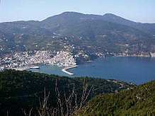
Skopelos ( Greek Σκόπελος ( f. Sg. ) 'Rocky cliff') - also called Peparethos in ancient times - is a Greek island in the Northern Sporades . Together with some surrounding uninhabited islets, Skopelos forms a municipality in the Thessaly region .
location
Skopelos is about 4 km west of Alonnisos , 8 km east of Skiathos and 25 km northeast of Euboea . With an area of 95.131 km² Skopelos is the second largest island in the Northern Sporades.
Geography of the island
The island of Skopelos consists of two rock massifs of unequal size. A narrow plain, which runs south from the bay of Skopelos, the main town, to Cape Stafilos, separates the two parts. The smaller, eastern part is very steep and inaccessible. The summit of the rock massif is called Palouki, the maximum height is 567 m.
The much larger western and northern parts have a maximum height of 682 m. The summit is called Delfi. The northeast coast is steep. There are numerous bays and beaches on the west and south coast.
The island is heavily forested, typical crops are wine and plums .
Community structure
Overview
Administratively, Skopelos is divided into two districts and a local community. The population figures are from the 2011 census.
- Municipality of Skopelos (Δημοτική Κοινότητα Σκοπέλου), 3,286 inhabitants
- Glossa district (Δημοτική Κοινότητα Γλώσσης), 1,168 inhabitants
- Local community climate (Τοπική Κοινότητα Κλήματος), 506 inhabitants
places
The main town of Skopelos is located in the southeast of the island, on the north coast. Skopelos is the economic center of the island and the most important port. A good half of the islanders live here. The historic old town is the center of attraction for tourism.
The other larger towns are in the north of the island:
- Glossa , the second largest town, is in the far north, 200 to 250 m above sea level.
- Loutraki is the port of Glossa and the port that ferries from Volos call first.
- (Palio) Klima is an old town in the north, not far from Glossa.
- Neo Klima (other name Elios) was created three kilometers south of Klima on the west coast in 1965 after the old town of Klima was badly damaged by an earthquake.
Otherwise there are only small villages and settlements on the island. Panormos is located on the largest bay on the west coast with an extensive beach. Agnondas on the south coast is the island's third port (with occasional ferry traffic). On the road between Agnondas and Panormos lie the settlements of Alikias, Ditropos and Loutsa, to the north of it Mortero. 1.5 km west of Agnondas is Limnonari on a picturesque bay.
In the interior of the island, at a distance of 5 to 6 km from the port of Skopelos, are Pefkias, Diakopi, Ananias, Pirgos, Karia and Pano Karia. The only place on the steep northeast coast - there is neither a beach nor a harbor - is Kalogeros.
Stafylos is located on the south-east coast at the end of the plain that leads south from the port of Skopelos and divides the island into two parts. Kambos and Aloupi are settlements in the immediate vicinity of Skopelos.
In the southeast part of the island, east of the plain between Skopelos and Stafilos, there are no settlements due to the steep terrain and inaccessible coast.
history
Archaeological research unearthed graves in Sendoukia, in the center of the island, which date back to the Neolithic period and suggest that there were already settlements on Skopelos at that time. In the Bronze Age , the island was a colony of Minoan Crete. In 1936 an extremely richly decorated grave was discovered. Among the accessories was a gilded sword from the late Helladic period. It is the largest Mycenaean sword discovered . Skopelos is the ancient Peparethos (Πεπάρηθος), which dates back to 342 BC. . BC by Philip of Macedon was devastated.
Skopelos was the residence of the singer Ivan Rebroff .
In the summer of 2007, the shooting of Mamma Mia! instead of.
Population numbers
| year | Residents |
|---|---|
| 1981 | 2,728 (Skopelos Municipality) |
| 1991 | 2,603 (Skopelos municipality), 4,658 (island) |
| 2001 | 3,027 (Skopelos municipality), 4,696 (island) |
| 2001 | 1,195 (Glossa municipality) |
| 2001 | 415 (Neo Klima municipality) |
literature
- T. Adamakopoulos, P. Matsouka: Skopelos 1: 25,000 . Anavasi Maps & Guides, Athens, 2007, ISBN 978-960-8195-22-6
Web links
- About Skopelos Island - The Skopelos Island local website
Individual evidence
- ↑ a b Results of the 2011 census at the National Statistical Service of Greece (ΕΛ.ΣΤΑΤ) ( Memento from June 27, 2015 in the Internet Archive ) (Excel document, 2.6 MB)
- ↑ Mamma Mia Skopelos. In: skopelosweb.gr. Accessed November 17, 2019 .


