Chalkidiki (regional unit)
|
Halkidiki regional unit Περιφερειακή Ενότητα Χαλκιδικής (Χαλκιδική) |
|
|---|---|
| Basic data | |
| State : | Greece |
| Region : | Central Macedonia |
| Area : | 2,918 km² |
| Residents : | 105,908 (2011) |
| Population density : | 36.3 inhabitants / km² |
| NUTS 3 code no. : | EL527 |
| Structure: | 5 municipalities |
| Website: | www.halkidiki.gov.gr |
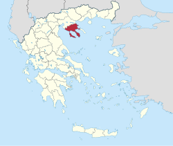
Chalkidiki ( Greek Χαλκιδική , other spellings: Chalcidice, Halkidikí, Khalkidikḗ, Khalkidhikí ) is one of the seven regional districts of the Greek region of Central Macedonia . Until the administrative reform of 2010 , the region formed a - since 1997 self-governing - prefecture, whose powers of the prefecture were transferred to the region of Central Macedonia and the municipalities, which were greatly reduced by amalgamation. The regional district sends four members to the Central Macedonian Regional Council, but beyond that it no longer has any political significance. The capital of Halkidiki is Polygyros .
Its area includes the peninsula of the same name in the north-western Aegean Sea , which resembles a hand with three 'fingers'. The three 'fingers' are Kassandra (older names Pallene, Phlegra ), Sithonia and Agion Oros (alternative name Athos ; older name Akt ). The monasteries of Athos are outside the prefecture and are an autonomous part ( suzerain ) of the Greek state.
The regional district of Chalkidiki is divided into the communities Aristotelis , Kassandra , Nea Propondida , Polygyros and Sithonia .
Individual evidence
- ↑ Results of the 2011 census at the National Statistical Service of Greece (ΕΛ.ΣΤΑΤ) ( Memento from June 27, 2015 in the Internet Archive ) (Excel document, 2.6 MB)
