Chalkidiki
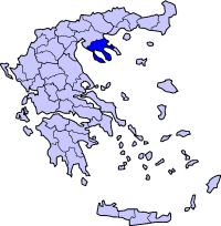
The Chalkidiki , also Halkidiki ( Greek Χαλκιδική ( f. Sg. ) [ Xalkiði'ki ], old Chalkidike , Latin Chalcidice ; for the origin of the name see antiquity ) is a peninsula on the mainland of Greece , in the administrative region of Central Macedonia , in Macedonia southeast of Thessaloniki on the Balkan Peninsula in Southeast Europe . It covers an area of 2918 km². The regional district of the same name is located on the peninsula . The coast of the peninsula is 522 km long.
Location and geography
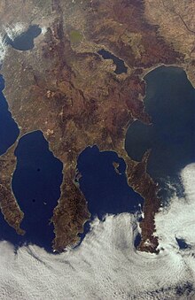
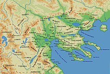
The Chalkidiki lies between the Thermaic and the Strymonic Gulf and protrudes into the Aegean Sea in three finger-like headlands : Kassandra (Pallene), Sithonia (peninsula) and Athos (Agion Oros). Between these headlands there are two large bays in the Aegean Sea. Between Kassandra and Sithonia the Toronean Gulf (Gulf of Kassandra) extends with its longitudinal axis to the northwest; also in the same direction the Singitian Gulf (Gulf of Agion Oros) between Sithonia and Athos. On the east side of the Chalkidki peninsula, the Gulf of Ierissos is separated from the Strymonian Gulf by two smaller peninsulas .
Due to its geographical shape, the Halkidiki is often compared to a three-fingered hand. In Greece or in Greek usage, the term "finger" is rarely used: here the three peninsulas Kassandra, Sithonia and Athos are referred to as "feet" instead of "fingers", with Kassandra the first foot or finger, Athos the third finger or foot is. With recourse to ancient Greek mythology , the Chalkidiki is often referred to as " Poseidon's trident ".
structure
Central country
In the west the country is hilly and slopes relatively flat to the thermal gulf. These areas are used for agriculture, and domestic and foreign tourism is now predominant on the coast itself. In the middle of Halkidiki rises the second highest mountain: Cholomondas (1,165 m height, thus the highest mountain in the regional district of Halkidiki). The Cholomondas massif is overgrown with a mixed forest that looks more like Central Europe . In the southeastern part of the Chalkidiki is also hilly. The originally existing forest of pine and pine trees has partly fallen victim to forest fires, partly plains between the hills are used for agriculture ( Megali Panagia , Paleochori, Gomati). In the north-eastern part there is also a large mixed forest area with a character similar to a low mountain range. There are few rivers and they all run dry in summer.
Kassandra
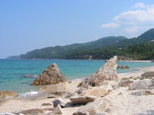
Kassandra is quite flat in the north and is used intensively for agriculture; slightly more hilly to the south towards the tip of the peninsula. The forest stands on Kassandra were decimated by forest fires, most recently considerably in 2006. Agriculture and tourism near the coast determine the appearance of the landscape. The highest point on Kassandra is about 400 m high. The coast consists mainly of extensive sandy beaches. There are also rocky sections of the coast, but the cliffs slope gently into the sea due to the hilly landscape structure. The ancient name of the peninsula was Pallene or Phlegra .
Sithonia
Sithonia is significantly more mountainous compared to Kassandra. The peninsula is crossed from north to south in the middle by the Itamos Mountains . The highest peak is the Itamos ( 817 m ). The entire mountain range is forested ( coniferous forest ), but the southern tip of Sithonia (from the height of Sarti / Sykia ) has lost the forest through forest fires. Sithonia's coast is mainly a steep coast , which has bays in many places ; these are sometimes very secluded and difficult to reach. In larger valleys towards the sea there are often villages, including Sykia, Sarti and Toroni . At the southwest tip is Porto Koufo , "the deaf harbor", a large natural harbor.
Athos
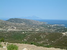
In the north, Athos is rather middle-mountainous forested. The highest point in Chalkidiki rises at the southern tip: Mount Athos (2033 m above sea level). Due to its special status as an autonomous monastic republic, Athos is relatively untouched. However, forest fires have also destroyed larger natural areas here. In ancient times the peninsula was also called nudes .
Islands
There are several islands in the area of Halkidiki . Only one has a village and is definitely permanently inhabited: Amouliani . It is also the largest of the islands in Halkidiki. On the islands in the lagoon of Vourvourou , especially on the island of Diaporos, there are now some houses, some of which are inhabited all year round. The island of Kelyfos located off Neos Marmaras , the island of Drenia located southeast of Ammouliani, the islands of Eleftheronisi and Kafkanas (east coast) on the east coast and Spalathronissa located south of Neos Marmaras are not permanently inhabited.
Waters
The water on the coasts is of good quality (EU blue flag). There are some rivers in Halkidiki, but they almost always dry up in summer. At Olynthos / Agios Mamas the Sandanos (Vathounia) and at Ormylia the Chavrias, which is also the longest river in Chalkidiki, flow into the sea. On the northern edge of the peninsula there is the Lake Volvi and Koronia Lake . Besides these interconnected lakes, there is only the small salt lake Aliki on the island of Amouliani.
climate
The climate of the Chalkidiki is divided into three vegetation seasons: rainy season, flowering and ripening season and dry season. While the climate on the coasts is typically Mediterranean, in the center of the peninsula more continental influences are noticeable (the peninsula has an extension of 101 km). The winter rainy season (November to February) is very rainy and very cool. Occasionally even snow falls, which can stay in the mountains until March / April. Temperatures range from 13 to 15 ° C during the day to around freezing point at night.
The flowering and ripening period begins in March. Then even the sandy beaches are covered with a carpet of flowers and small plants. The temperatures are similar to the Central European spring (10–22 ° C).
The campsites will not open until the summer period, which begins in June. The midday temperatures are not infrequently above 30 ° C, and there is an increased risk of forest fires. This period lasts into October. Showers and thunderstorms occur more often than in other regions of Greece, due to the high mountain ranges and the connection to the mainland. The water temperatures are 22-27 ° C, depending on the shape of the coast.
| Chalkidiki | ||||||||||||||||||||||||||||||||||||||||||||||||
|---|---|---|---|---|---|---|---|---|---|---|---|---|---|---|---|---|---|---|---|---|---|---|---|---|---|---|---|---|---|---|---|---|---|---|---|---|---|---|---|---|---|---|---|---|---|---|---|---|
| Climate diagram | ||||||||||||||||||||||||||||||||||||||||||||||||
| ||||||||||||||||||||||||||||||||||||||||||||||||
|
Average monthly temperatures and rainfall for Halkidiki
Source: Weather in Halkidiki
|
|||||||||||||||||||||||||||||||||||||||||||||||||||||||||||||||||||||||||||||||||||||||||||||||||||||||||
Flora and fauna
Due to the abundance of water on the peninsula, there is a great variety of plants here, which can be divided into three types of vegetation: forests, macchia and some cultivated plants.
Resin is harvested from the bark of the Aleppo pine , which is related to the pine , which gives the retsina its taste. The sweet chestnut is mainly found in the higher areas. Roast chestnuts are a typical dish for the area. Also eucalyptus trees that pose a significant risk of forest fires, occurred just as typical of all Mediterranean regions plane trees and cypresses on.
Macchia growth
The maquis , an area of evergreen bushes, consists mainly of the Kermes oak , the holm oak , the strawberry tree and the gorse in Halkidiki . The rockrose is also widespread . It grows on the hard rock and gives off a resinous odor.
Crops
The cotton plant is grown on flat hills and sun-drenched valleys and harvested in mid-September. The cultivated plants fig and pomegranate can also be found. Tobacco is planted and processed in large fields in Chalkidiki. Many Albanian guest workers are now involved in this. The most important crop, however, is the olive tree typical of Greece . The olives are harvested from October to December and then mostly processed into oil and exported.
history
Halkidiki has been settled since an early age.
Early days

In the stalactite cave of Petralona 200,000 year old human remains of Homo heidelbergensis were found. In the same cave, remains of ashes from a fire were found, which is about 1.0 million years old. It is unclear whether this fire was caused by human hands or accidentally.
Remains of pre-ancient settlements, which were inhabited by Thracians , can be found in Olynthos, Galatista, Vassilika, Sani, Afytos and Toroni, among others. The earliest to be dated finds come from the 4th millennium BC. There are also pile dwellings from the early Bronze Age.
Antiquity
The name Halkidiki comes from the numerous cities that were inhabited by inhabitants of the Greek islands, especially Euboea and Andros , since the 8th century BC. Under the leadership of the city of Chalkis . In addition to the people from Euboä, Bottieans also settled between Olynthos and today's Nea Kallikrateia (west coast). In the 5th century BC, Halkidiki already had several cities and towns: Dikaia, Aineia, Smila (in the Crusis), Skapsa, Gigonos, Aisa, Vrea, Lipaxos, Potidaia , Sane (Sani) on Kassandra, Mende (Greece) , Skione, Therambos, Afytis (Afytos), Mekyberna (Mekyverna), Sermyle ( Ormylia ), Galepsos (Gale), Torone , Sarte ( Sarti ), Singos , Pyloros, Assa, Sane on Athos, Thyssos, Kleonai on the Chalkidiki, Akrothooi , Dion , Akanthos , Stageira (Stagira), Arethoussa, Arnae and Anthemous ( Anthemoundas ).
The most important cities were Olynthos and Potidaia , the only Doric colony on the peninsula. After the Persian Wars in the middle of the fifth century BC, the whole landscape joined the Attic League . 432 BC A conflict developed between Athens and Corinth, or Sparta, over the autonomy of the city of Potidaia, which is seen as a co-trigger of the Peloponnesian War. Potidaia entered 431 BC. From the Attic League and was subsequently besieged by Athens as part of the Peloponnesian War and then captured.
The Chalcidian League existed on the north-west coast of the Aegean Sea from about 430 BC. With the defeat of Athens in the Peloponnesian War in 404 BC. The Attic League was also dissolved.
Later Philip II of Macedonia conquered the colonies of the Greek city-states on the peninsula in the Second Olynthian War , and Halkidiki became after the breakup of the Chalcidian League in 348 BC. Finally part of the Macedonian Kingdom .
As part of the Roman conquest of Greece (here: Macedonia) in 146 BC The Halkidiki came under the rule of the Roman Empire. With the division of the empire into western and eastern currents, Chalkidiki fell to eastern currents , the later Byzantine empire .
Modern times
In 1821 the Chalkidiki took part in the fighting during the Greek War of Independence , but could not shake off the rule of the Ottoman Empire . This only succeeded in the course of the 2nd Balkan War in 1913. It then became part of the Greek state.
From 1941 to 1944 Halkidiki was under German occupation during the Second World War .
The first draft of a European constitution was presented at an EU summit that took place in the Porto Carras hotel complex in 2003 .
economy
Natural resources
The ore deposits of the Chalkidiki ( copper , chromium , manganese , silver , gold , pyrites and magnesite ) are important for the Greek economy . The latter is the most important. It is mined near Gerakini and Vavdos in opencast mines and most of it is exported.
There are large unused natural gas reserves.
Agriculture
Chalkidiki is also known for the olive oil , which comes from the south and west , as well as cotton and honey in many varieties (for example with pickled walnuts or honeycombs). Well-known wines such as Agioritiko are also popular export goods.
tourism
The tourism industry, especially around Kassandra and Sithonia, has great economic potential. However, this has faltered since around 2002. Small campsites in particular have a hard time; however, some were effectively supported by the EOT (Ellinikos Organismos Tourismou). Hopes that the 2004 Olympic Games could change the situation have been dashed. The government is now trying to stimulate tourism by expanding the infrastructure.
Structure, residents, places
Today's administrative structure
Chalkidiki is one of the regional districts in Greece today . The capital is Polygyros (about 5,000 inhabitants). Polygyros is located in the middle of the Chalkidiki in the middle of a plateau. The regional district of Chalkidiki extends in the north to the lakes Volvi and Keronia, in the west, south and east the sea forms the border. Belong not to the regional district is Athos , the peninsulas of Kassandra and Sithonia whereas for the Regional District Chalkidiki belong.
Residents
Mostly Greeks live in Halkidiki . Some of the Greek residents have been resident for a long time, while others have moved there as part of the so-called "Asia Minor Catastrophe" as a result of the Greco-Turkish War of 1922 and the subsequent population exchange from the former Greek settlement areas of Asia Minor . The settlements founded by these immigrants and displaced persons can usually be recognized by the name component Nea or Neos, which means new (example: Neos Marmaras = New Marmaras).
In the course of the development, many people from Northern Greece, especially from Thessaloniki , at least as weekend trippers, have created a (second) place to stay. Northern and Central Europeans have also become permanent residents of Chalkidiki.
| year | 1991 | 1993 | 1995 | 1997 | 1999 | 2001 | 2003 | 2005 |
|---|---|---|---|---|---|---|---|---|
| population | 86.141 | 90.036 | 92.904 | 95,489 | 97,543 | 98,801 | 99,943 | 104,894 |
All information according to the "Greek Statistical Office". The population density is 35.9 inhabitants per square kilometer.
Places and cities
The cities and towns of Halkidiki are currently (sorted by geographical location):
| Place present | Community present | Place antiquity | location | Residents | function |
|---|---|---|---|---|---|
| Kassandra (1st finger) | |||||
| Kallithea | Kassandra | Neapolis | East coast center, right by the sea | 779 | Main town tourism on Kassandra |
| Afytos | Kassandra | Afytos | Kassandra, east coast, north | 1,231 | |
| Chaniotis | Pallini | East coast | |||
| Kalandra | Kassandra | West Coast | |||
| Nea Fokea | Kassandra | Phocaea | Kassandra, east coast, north | 1,721 | |
| Nea Potidea | Moudania | Potidaia | Kassandra, north, isthmus | 1,588 | Potidea Canal , fishing port |
| Pefkochori | Pallini | Kapsochora | South, inland | ||
| Paliouri | Pallini | Therambos | South, inland | 826 | |
| Kassandria | Kassandra | Kassandreia | Northern part, inland | 2,801 | |
| Nea Skioni | Pallini | West Coast | |||
| Sithonia (2nd finger) | |||||
| Nikiti | Sithonia | Galepsos (?), Sermyle | West coast, north, right by the sea | 2,769 | |
| Agios Nikolaos | Sithonia | Singos | East coast, north, 1.5 km from the sea | 1.925 | |
| Neos Marmaras | Sithonia | Galepsos (Gale) | West coast, center, right by the sea | 2,854 | |
| Sarti | Toroni | Sarte (?) | East coast | ||
| Sykia | Toroni | Sarte (?) | East coast, south, 3 km from the sea | 2,353 | |
| Toroni | Toroni | Toroni, Torone | West coast, right by the sea | 233 | |
| Athos (3rd finger) | |||||
| Ouranoupoli | Stagira-Akanthos | Sane (sani) | West coast, north of Athos (border) | 960 | |
| Trypiti | Stagira-Akanthos | West coast, north of Ouranoupoli | |||
| Central country (palm) | |||||
| Nea Moudania | Moudania | West coast, north of Kassandra, by the sea | 6,475 | most important fishing and ferry port | |
| Nea kallikrateia | Callikratia | West coast, right by the sea | 6,204 | ||
| Nea Plagia | Moudania | West coast, right by the sea | 1,249 | ||
| Ormylia | Ormylia | Sermyle | North Toronian Gulf Coast | 3,272 | |
| Olynthos | Polygyros | Olynthos , Mekyberna | North Toronian Gulf Coast | 1,131 | |
| Arnea | Arnea | North edge of the Cholomondas massif, inland | 2,253 | ||
| Polygyros | Polygyros | Western edge of the Cholomondas massif, inland | 5,040 | Capital of the regional division, hospital | |
| Megali Panagia (Revenikia) | Panagia | Inland | 2,727 | ||
| Ierissos | Stagira-Akanthos | Akanthos | East coast, south | 3,046 | most important port in the east |
| Galatista | Anthemoundas | West, inland | 2,662 | ||
| Paleochori | Arnea | Center, inland | 1,507 | ||
| Taxiarchis | Polygyros | Center, Cholomontas | 1,070 | ||
| Varvara | Arnea | Central country, east | |||
traffic
automobile
Halkidiki is very well developed , especially for road traffic . Two main routes lead from Thessaloniki to Chalkidiki. The first route runs through inland via Polygyros , Arnea , Ierissos to Ouranopolis (National Road 16 ( GR-EO16 )).
The second route runs along the sea (west coast) via Nea Kallikrateia to Nea Moudania (national road 67, GR-EO67 ). This route is the main route from Thessaloniki to Chalkidiki and is accordingly heavily frequented during the holiday season or on weekends in summer. The road from Thessaloniki to Nea Moudania is meanwhile developed like a motorway to Nea Kallikrateia (GR-EO67). It is toll-free, a further expansion via Nea Moudania to Nea Potidea on Kassandra is currently in progress.
From Nea Moudania a road leads to Kassandra, which is developed with a ring road, and another road leads along the north coast of the Toronean Gulf to Nikiti / Agios Nikolaos on Sithonia.
The Cassandra ring road begins and ends in Kallithea. It runs along the coast of Kassandra, but does not reach the southern tip of Kassandra.
Sithonia itself is also developed with a 111 km long ring road. It starts between Nikiti and Agios Nikolaos and runs along the coast around the peninsula.
From Agios Nikolaos a road leads along the north coast of the Singitian Gulf to Ierissos or inland to Arnea or Megali Panagia . All major roads are paved and generally easy to drive on. However, potholes and falling rocks are still to be expected.
bus
There is a brisk bus traffic as this is the backbone of public transport in Chalkidiki and Greece ( KTEL ). The central hubs for bus connections in Chalkidiki are Nea Moudania and Polygyros . All villages in Chalkidiki are approached several times a day depending on the season. There are significantly more connections in summer than in winter. There is also a bus connection to Thessaloniki from most towns.
railroad
Halkidiki has no railroad. The only connection option is the Thessaloniki train station. From there, the onward journey to Chalkidiki must be made by car, bus or taxi.
Air traffic
Chalkidiki has no public airfields or international airports. The airport of Thessaloniki ( Makedonia Airport ) functions as an international airport . Chalkidiki is directly connected to this via the motorway-like connection Thessaloniki- Nea Moudania . In addition, the small airport of Kavala is used by some tour operators for charter air traffic to and from Chalkidiki.
particularities
Athos (Agion Oros) is part of the state of Greece with privileges and is inhabited exclusively by Orthodox monks (all men). Men are only allowed to enter Athos with a visa that has been applied for in advance , women have been banned for more than 900 years ( Adiabaton decree of the Byzantine emperor). Boats or ships carrying female passengers are also only allowed to approach the coast from a distance of several kilometers. During the Greek civil war , women found temporary asylum on the mountain.
Attractions
- Petralona Cave - site of prehistoric people
- Potidea Canal - small version of the Corinth Canal
- Ancient Olynthos
- Ancient Stageira - birthplace of Aristotle (today Olympiada )
- Forests of the Cholomontas massif
- Forests of Northeast Halkidiki
- Beaches of Sithonia
- Kassandra beaches
- Rentina Fortress
- Frangokastro near Ouranopolis on the border with Athos
- Xerxes Canal near Nea Roda , of which almost nothing can be seen on the outside except for a sign
- Vourvourou lagoon and islands in Sithonia
- Parthenonas - abandoned, then derelict and re-inhabited typical village (near Neos Marmaras )
- Temple of Ammon Zeus - at Kallithea
- Sani
Celebrations and events
- Swim through the Toronean Gulf from Kallithea to Nikiti
Famous people from Halkidiki
- Paionios von Mende (second half of the 5th century BC), sculptor
- Herodotus of Olynthus (4th century BC), sculptor, father of Sthennis
- Sthennis (4th century BC, born in Olynthos), ore caster
- Herodorus , sculptor, son of Sthennis
- Nicomachus, father of Aristotle, personal physician to King Amyntas III. of Macedonia
- Aristotle (* 384 BC in Stageira ; † 322 BC), philosopher and natural scientist
- Aristobulus of Kassandreia (* 375 BC; † after 301 BC), historian and builder
- Callisthenes (* around 370 BC in Olynthos ; † around 327 BC), historian
- Andronikos from Olynth (* around 370 BC), Phrourarchos from Tire , installed by Antigonus
- Ephippos of Olynthos (second half of the 4th century BC, * before 348 BC in Olynthos), historian
- Krates von Olynth, mining and hydraulic engineer for Alexander the Great
- Poseidippus of Pella or Kassandreia (* around 310 BC; † around 240 BC), Hellenistic comedy poet and epigrammatist
- Bubalos from Kassandreia (Βούβαλος ἐκ Κασσανδρείας), victorious racehorse in the Arcadian Lykaia of the year 304 BC Chr.
- Erginos, son of Simylos, from Cassandreia, victorious Kitharöde in the Delphic Soteria of 260 BC. Chr.
- Aquilina of Zagliveri or of Thessaloniki (also Akelina of Soluneia ; † 1764), martyr (name day on September 27 )
- Konstantinos (Theofilou) Doumbiotis , (* around 1793 in Doumbia ; † around 1849), initially an Ottoman administrative officer (Subaşi), then a revolutionary in the Greek War of Independence (1821–1830)
- Anastasios Chymevtos (* 1795 in Kassandreia (then Valta), † 1853), mayor in Kassandreia, later leader of the free army in the Greek War of Independence (1821-1830)
- Athanasios Stageiritis , Professor of Greek Literature at the Imperial Academy of Sciences , from 1819 to 1821 editor of the literary journal Kalliope (Vienna)
- Stamatios Kapsas also Kapetan Chapsas ( Captain Devourer , * in Kryopigi (then Pazarakia); † June 10, 1821), Kleftis and militant leader in the Greek War of Independence (1821-1830)
- Nikolaos Germanos (* 1864 in Vavdos ; † 1935), zoologist
- Chrysostomos Kalafatis (* 1867 in Triglia ; † September 9, 1922), Archbishop of Smyrna 1919–1922
- Manolis Mitsias (born February 26, 1944 in Doumbia), singer
- Sokratis Malamas (born September 29, 1957 in Sykia ), songwriter, singer and guitarist
- Giannis Gianniotas (* 1993), football player
literature
- Klaus Bötig : Chalkidiki. Travel with insider tips. Marco Polo travel guide. 5th edition. Mairs Geographischer Verlag, Ostfildern 2002, ISBN 3-8297-0116-0 .
- Chalkidiki. Tourist guide. Adam Editions, ISBN 960-500-208-6 .
- Ioakim Athanassios Papangelos: Chalkidiki. 3. Edition. Malliaris Paidia, Athens 2002, ISBN 960-86691-3-8 .
- Andreas Neumeiter: Chalkidiki. Müller-Michael, Erlangen 2006, ISBN 3-89953-256-2 .
- Eva Winter : city tracks. Evidence of the urbanization of the Chalkidike (= Frankfurter Archäologische Schriften . Vol. 3). Reichert, Wiesbaden 2006, ISBN 3-89500-558-4 (also dissertation, University of Heidelberg 2001).
- Michael Zahrnt : Olynthos and the Chalkidians. Studies on the formation of states on the Chalcidian Peninsula in the 5th and 4th centuries BC Chr. Beck, Munich 1971, ISBN 3-406-03097-1 , pp. 226-229. (Vestigia, 14)
- ["Sithonia The Pearl of Chalkidikis" by Hannes Matthiesen. Very personal guide. Create Space USA 2013, ISBN 978-1-4903-0161-7 ]
Web links
- Link catalog on the topic of Chalkidiki at curlie.org (formerly DMOZ )
Individual evidence
- ^ Nicholas Cahill: Household and City Organization at Olynthus: Philip's Destruction of Olynthus . (No longer available online.) 2002, archived from the original on June 7, 2011 ; accessed on July 11, 2016 . Info: The archive link was inserted automatically and has not yet been checked. Please check the original and archive link according to the instructions and then remove this notice.
- ↑ Explosive natural resources under Epanomi in Greece. In: greece-blog.gr. Retrieved July 11, 2016 .
- ↑ Article 105 (1) of the Constitution of Greece translates as follows: The Athos peninsula, from Megali Vigla on, which forms the district of the Holy Mountain, is, according to its old privileged status, a self-governing part of the Greek state, its sovereignty over the saint Mountain remains untouched. Spiritually, the Holy Mountain is under the direct jurisdiction of the Ecumenical Patriarchate. Those who withdraw there acquire Greek citizenship with their approval as a novice or monk without any further formalities.
- ^ Arcadia . - Lykaia . - Epigraphical Database
- ↑ Phocis . - Delphi . - Epigraphical Database
- ^ Saint Aquilina of Thessalonica. Retrieved July 11, 2016 .
- ↑ St. Aquilina. Retrieved July 11, 2016 .
Coordinates: 40 ° 30 ' N , 23 ° 25' E

