
Sithonia (municipality)
|
Municipality of Sithonia Δήμος Σιθωνίας (Σιθωνία) |
|||
|---|---|---|---|
|
|||
| Basic data | |||
| State : |
|
||
| Region : | Central Macedonia | ||
| Regional District : | Chalkidiki | ||
| Geographic coordinates : | 40 ° 13 ' N , 23 ° 42' E | ||
| Area : | 514.70 km² | ||
| Residents : | 12,394 (2011) | ||
| Population density : | 24.1 inhabitants / km² | ||
| Seat: | Nikiti | ||
| LAU-1 code no .: | 1305 | ||
| Districts : | 2 parishes | ||
| Local self-government : |
4 city districts 2 local communities |
||
| Website: | www.dimossithonias.gr | ||
| Location in the Central Macedonia region | |||
 |
|||

Sithonia ( Greek Σιθωνία ( f. Sg. )) Is a Greek community created in 1997 ( Dimos Sithonias Δήμος Σιθωνίας) in the regional district of Chalkidiki in the administrative region of Central Macedonia . Its area completely occupies the peninsula of the same name ("finger") and extends north to the southern central land of the Chalkidiki peninsula. The municipality was formed in 1997 as part of the Greek local government reform Schedio Kapodistrias from the previously independent municipalities (Kinotites) and localities Nikiti , Agios Nikolaos , Metangitsi and Neos Marmaras and expanded in 2011 to include the neighboring municipality of Toroni to the south . The administrative seat of the municipality of Sithonia is the village of Nikiti.
Geography, climate and geology

The municipality of Sithonia extends from the southern middle central land of the Chalkidiki peninsula with the area of the village Metangitsi along the Sithonia peninsula to the south and takes on the peninsula throughout its area and is in the west of Toroneos Gulf , on the east by Singitischen Golf limits . In the north the municipality of Sithonia borders with the municipalities of Nikiti, Agios Nikolaos and Metangitsi on the municipality of Polygyros , in the northeast the municipality of Agios Nikolaos of the municipality of Sithonia forms the border with the municipality of Panagia of the municipality of Aristotelis . The eastern and southeastern municipal area are formed by the municipality of Agios Nikolaos: it forms the coast of the Singitian Gulf to the east and southeast . Sarti and Toroni form the south of the municipality .
The municipality of Sithonia completely encompasses the isthmus of the Sithonia peninsula. This is characterized by a hilly landscape. The mountain Vrachoto (492 m altitude) rises to the north in the direction of the central country of Chalkidiki and separates the municipal districts of Metangitsi in the north and Agios Nikolaos in the south. Further to the northwest this mountain merges into the Psilo (455 m height). The municipality of Metangitsi is located in a slightly hilly depression that leads from northwest to southeast to the sea. Its north-eastern limit is the Marmaras and Axandas hills, which separate the municipality of Sithonias from the Panagias. The municipality located south of the isthmus of Sithonia is dominated by the ridge of the Itamos (808-811 m altitude, depending on the source). This forms the central mountain range of the Sithonia Peninsula in its longitudinal axis from northwest to southeast. Its highest point is the peak Astrapokammeno Pefko (817 m), the second highest peak in the municipality is the mountain Karvounas with 567 m, located immediately south-southeast of the village Vourvourou, which merges seamlessly into the Itamos massif to the southwest.

Karvounas mountain, altitude 567 m

View of the Itamos mountain (811 m) from the entrance to the Porto Karras hotel complex, Neos Marmaras district

View from Hotel Meliton to the village of Neos Marmaras (in the background)

_Mountain,_Sithonia,_Chalkidiki,_Greece_-_View_from_Porto_Carras_Entrance.jpg)

The municipality of Sithonia has two noteworthy rivers, which, however, carry little or no water in summer. The river Chavrias passes through the municipality in the town of Metangitsi and forms the border between the municipality of Sithonia and Ormylia for a few kilometers in its course to the Toronean Gulf. The Tragoula brook flows from the northwestern foothills of the Itamos in the isthmus of Sithonia to the west-northwest and flows south of the village of Nikiti at Cape Kastri into the Toronean Gulf.
The coastlines of the municipality are richly structured: In addition to open bays with extensive sand or gravel beaches, there are also small, more secluded bays. A significant part of the coast, especially on the coast of the Singitian Gulf, is formed by cliffs. The municipality of Sithonia also includes a large number of islands: In the bay of Vourvourou in the Singitian Gulf (municipality of Agios Nikolaos) there are the islands of Diaporos, Agios Isidoros, Ambelitsi and Kalomonisia. A little northwest of it between Cape Ritsos and the Livari peninsula is the island of Kalogria in a separate bay. In the Toronean Gulf, a few kilometers southwest of the coast of Neos Marmaras, lies the island of Kelyfos . According to official sources, all of the islands are uninhabited, with the exception of Spalathronisia, south of Neos Marmaras. In addition, eyewitness reports and photographs show several houses on the islands off Vourvourou, especially on the island of Diaporos.

Kalomonisia Islands and Diaporos Island in the municipality of Agios Nikolaos

View of the southeast side of Agios Nikolaos
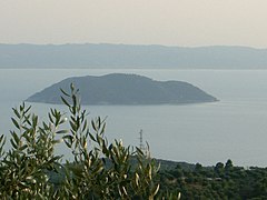
Kelyfos Island, Neos Marmaras Municipality

View of the village of Neos Marmaras
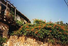
Abandoned traditional Greek house in Parthenonas, Neos Marmaras parish


history
The area of the municipality of Sithonia has been settled since the Paleolithic (Palaeolithic) era. In antiquity around the 7th century BC BC people from the city of Chalkis on the island of Evia settled in the area of the municipality and founded the cities (Polis) Singos and Galepsos (Gale). Singos was located in the area of today's municipality of Agios Nikolaos, Galepsos in the area of today's municipality of Neos Marmaras. The cities of Singos and Galepsos, like the rest of the Sithonia peninsula, belonged to the original Chalcidian settlement area until 479 BC. BC 480 BC The Persian King Xerxes I passed the area of today's municipality of Sithonia on his campaign against the Greek city-states, especially Athens, and recruited soldiers from the cities of Singos and Galepsos for his campaign. After the Persian defeat in 479 BC. BC and the retreat of the Persian army from what is now Greece, the cities of Singos and Galepsos joined the Attic League and were thus under the hegemony of Athens . In the tribute lists of the Attic Seebund payments from the city of Singos to the federal treasury of the Seebund for the period 452/451 BC. Prove that the city of Gale (Galepsos) paid 436 BC. Payments to the federal treasury. In the run-up to the Peloponnesian War , the cities of Singos and Galepsos left the Attic League: they had previously entered into an alliance with the city of Potidaia on the Kassandra peninsula , which became a point of conflict between the hegemonic efforts of Athens on the one hand and Sparta on the other. The Macedonian king Perdiccas recommended after the Chalkidic cities left the Attic League that the population of some cities should be amalgamated into one larger city (Synoikismos, Anoikismos). The cities of Galepsos (Gale) and Singos lost most of their population to the now considerably grown Olynthos as part of this " settlement" . In 431 BC The Peloponnesian War, which began at the beginning of the 4th century BC, became the scene of fighting between Athens and Sparta. 425 BC The Athenians succeeded in conquering Singos and Galepsos. The 421 BC The peace agreements concluded with Nikias in the 3rd century BC envisaged a return of the population who had emigrated / resettled to Olynthos for Galepsos and Singos: this took place - if at all - only to a very limited extent. Both from the city of Galepsos and from the city of Singos were lost after 421 BC. Chr. References to their settlement history.
The area of the two ancient cities and today's municipality of Sithonia then became part of the Chalkidian League under the leadership of the city of Olynthos . The defeat of the Chalcidian League and Olynths in the First Olynthian War 382 to 379 BC Chr. Changed nothing in the affiliation of today's municipality to the Chalkidischen Bund. The Second Olynthian War 350 to 348 BC BC ended with the defeat and dissolution of the Chalkidic League and the destruction of the city of Olynthos: the victorious Kingdom of Macedonia under Philip II took control of the entire peninsula of Chalkidiki and thus also of today's area of the municipality of Sithonia.
Administrative structure
The municipality of Sithonia is made up of the following municipal districts, city districts or local communities and settlements (population figures from 2011 census):
- Sithonia municipality - Δημοτική Ενότητα Σιθονίας - 8,841 inhabitants
- Agios Nikolaos district - Δημοτική Κοινότητα Αγίου Νικολάου - 1,895 inhabitants
- Agios Nikolaos - Άγιος Νικόλαος - 1,714 inhabitants
- Aimelitsi - Αϊμπελίτσι - uninhabited
- Diaporos (island) - Διάπορος - 2 inhabitants
- Eleonas - Ελαιώνας - 3 inhabitants
- Elijah - Ελιά - uninhabited
- Fteroti - Φτερωτή - uninhabited
- Galini - Γαλήνη - uninhabited
- Lagonisi - Λαγονήσι - 9 inhabitants
- Ormos Panagias - Όρμος Παναγίας - 30 inhabitants
- Peristeri - Περιστέρι - uninhabited
- Pyrgos - Πύργος - uninhabited
- Salonikiou - Σαλονικιού - 31 inhabitants
- Schinia - Σχοινιά - 6 inhabitants
- Vourvourou - Βουρβουρού - 100 inhabitants
- Zografou - Ζωγράφου - uninhabited
- Nikiti municipality - Δημοτική Κοινότητα Νικήτης (Νικήτα) - 2,789 inhabitants
- Elia - Ελιά - 78 inhabitants
- Nikiti (Nikitas) - Νικήτη (Νικήτας) - 2,711 inhabitants
- Neos Marmaras district - Δημοτική Κοινότητα Νέου Μαρμαρά - 3,352 inhabitants
- Agia Kyriaki - Αγία Κυριακή - 11 inhabitants
- Azapiko - Αζάπικο - 5 inhabitants
- Galini - Γαλήνη - 35 inhabitants
- Imeri Elia - Ήμερη Ελιά - 26 inhabitants
- Kelyfos (island) - Κέλυφος (νησίς) - uninhabited
- Limani Karra - Λιμάνι Καρρά - 95 inhabitants
- Neos Marmaras - Νέος Μαρμαράς - 3,158 inhabitants
- Parthenonas - Παρθενώνας - 21 inhabitants
- Spalathronisia (island) - Σπαλαθρονήσια (νησίς) - uninhabited
- Styladario - Στυλαδάριο - 2 inhabitants
- Local community Metangitsi - Τοπική Κοινότητα Μεταγκιτσίου - 805 inhabitants
- Agii Theodori - Άγιοι Θεόδωροι - 3 inhabitants
- Metangitsi - Μεταγκίτσι - 802 inhabitants
- Agios Nikolaos district - Δημοτική Κοινότητα Αγίου Νικολάου - 1,895 inhabitants
-
Toroni municipality - Δημοτική Ενότητα Τορώνης - 3,553 inhabitants
- City district Sykia - Δημοτική Κοινότητα Συκιάς - 2,397 inhabitants
- Destenika - Δεστενίκα - 24 inhabitants
- Kalamitsi - Καλαμίτσι - 39 inhabitants
- Koufos (Porto Koufos) - Κουφός - 110 inhabitants
- Paralia Sykia (Sykia Beach) - Παραλία Συκιάς - 77 inhabitants
- Pigadaki - Πηγαδάκι - 6 inhabitants
- Platania - Πλατάνια - 9 inhabitants
- Sykia - Συκιά - 1,903 inhabitants
- Toroni - Τορώνη - 213 inhabitants
- Valti - Βαλτί - 16 inhabitants
- Local community Sarti - Τοπική Κοινότητα Σάρτης (Σάρτη) - 1,156 inhabitants
- City district Sykia - Δημοτική Κοινότητα Συκιάς - 2,397 inhabitants
literature
- Halkidiki 1: 150,000. Road Editions, Athens. ISBN 960-8481-90-2 .
- Établissement Principal du Service Hydrogeographique et Océanographique de la Marine. Cote Est de Grece. De Evvoïkós Kólpos (partie north) à Kólpos Kaválas. 1: 250,000. BP 30316-29603, Brest Cedex 2005.
Web links
Individual evidence
- ↑ a b Results of the 2011 census at the National Statistical Service of Greece (ΕΛ.ΣΤΑΤ) ( Memento from June 27, 2015 in the Internet Archive ) (Excel document, 2.6 MB)
- ↑ Angelos D. Smagas: Human presence and habitation in prehistoric Sithonia. Original title: Ανθρώπινη παρουσία και κατοίκηση στην προϊστορική Σιθωνία. Dissertation, Aristotle University of Thessaloniki, Thessaloniki 2007.
- ↑ Michael Zahrnt : Olynth and the Chalkidians. Studies on the formation of states on the Chalcidian Peninsula in the 5th and 4th centuries BC Chr. CH Beck, Munich 1971, ISBN 3-406-03097-1 , map V.
- ↑ Michael Zahrnt: Olynth and the Chalkidians. Studies on the formation of states on the Chalcidian Peninsula in the 5th and 4th centuries BC Chr. CH Beck, Munich 1971, ISBN 3-406-03097-1 , map I.
- ↑ Michael Zahrnt: Olynth and the Chalkidians. Studies on the formation of states on the Chalcidian Peninsula in the 5th and 4th centuries BC Chr. CH Beck, Munich 1971, ISBN 3-406-03097-1 , p. 11.
- ↑ a b Michael Zahrnt: Olynth and the Chalkidians. Studies on the formation of states on the Chalcidian Peninsula in the 5th and 4th centuries BC Chr. CH Beck, Munich 1971, ISBN 3-406-03097-1 , p. 33ff.
- ↑ Michael Zahrnt: Olynth and the Chalkidians. Studies on the formation of states on the Chalcidian Peninsula in the 5th and 4th centuries BC Chr. CH Beck, Munich 1971, ISBN 3-406-03097-1 , p. 48.
- ↑ a b c Michael Zahrnt: Olynth and the Chalkidians. Studies on the formation of states on the Chalcidian Peninsula in the 5th and 4th centuries BC Chr. CH Beck, Munich 1971, ISBN 3-406-03097-1 , pp. 179, 229.