Amfipoli (Municipality)
|
Amfipoli municipality (Δήμος Αμφίπολης) |
||
|---|---|---|
|
|
||
| Basic data | ||
| State : |
|
|
| Region : | Central Macedonia | |
| Regional District : | Serres | |
| Geographic coordinates : | 40 ° 55 ' N , 23 ° 55' E | |
| Area : | 414.3 km² | |
| Residents : | 9,182 (2011) | |
| Population density : | 22.2 inhabitants / km² | |
| Community logo: | ||
| Seat: | Rodolivos | |
| LAU-1 code no .: | 1202 | |
| Districts : | 4 municipal districts | |
| Local self-government : |
1 city district 13 local communities |
|
| Website: | www.dimos-amfipolis.gr | |
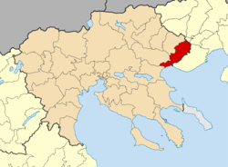
| Location in the Central Macedonia region | ||
The municipality Amfipoli ( Greek Δήμος Αμφίπολης ) was formed on January 1, 2011 from the merger of four municipalities in the southeast of the Greek region of Central Macedonia . The center and administrative seat of the municipality is Rodolivos . The community has an area of 414.3 km² and 9182 inhabitants.
structure
The municipality of Amfipoli is divided into four municipal districts, which correspond to the original municipalities.
The population figures come from the results of the 2011 census.
-
Amfipoli Municipality - Δημοτική Ενότητα Αμφίπολης - 2,615
- Local community Amfipolis - Τοπική Κοινότητα Αμφιπόλεως - 185
- Amfipolis - Αμφίπολις - 147
- Nea Amfipolis - Νέα Αμφίπολις - 38
- Local community Mesolakkia - Τοπική Κοινότητα Μεσολακκιάς - 341
- Mesolakkia - Μεσολακκιά - 16
- Nea Mesolakkia - Νέα Μεσολακκιά - 325
- Local community Nea Kerdylia - Τοπική Κοινότητα Νέων Κερδυλίων - 645
- Akti Neon Kerdylion - Ακτή Νέων Κερδυλίων - 49
- Limani - Λιμάνι - 4
- Logkari - Λογκάρι - 24
- Nea Kerdylia - Νέα Κερδύλια - 538
- Sykia - Συκιά - 30
- Local community Paleokomi - Τοπική Κοινότητα Παλαιοκώμης - 1.444
- Nea Fyli - Νέα Φυλή - 170
- Paleokomi - Παλαιοκώμη - 1,274
- Local community Amfipolis - Τοπική Κοινότητα Αμφιπόλεως - 185
- Municipality of Kormista - Δημοτική Ενότητα Κορμίστας - 1.912
- Local community Iliokomi - Τοπική Κοινότητα Ηλιοκώμης - 342
- Iliokomi - Ηλιοκώμη - 342
- Local community Kormista - Τοπική Κοινότητα Κορμίστας - 579
- Kormista - Κορμίστα - 555
- Moni Ikosofinissis - Μονή Εικοσιφοινίσσης - 24
- Local community Nea Bafra - Τοπική Κοινότητα Νέας Μπάφρας - 716
- Akti Nea Bafra - Νέα Μπάφρα - 716
- Local community Symvoli - Τοπική Κοινότητα Συμβολής - 275
- Ano Symvoli - Άνω Συμβολή - 23
- Symvoli - Συμβολή - 252
- Local community Iliokomi - Τοπική Κοινότητα Ηλιοκώμης - 342
- Proti Parish - Δημοτική Ενότητα Πρώτης - 2.044
- Local community Angista - Τοπική Κοινότητα Αγγίστης - 295
- Angista - Αγγίστα - 295
- Local community Krinida - Τοπική Κοινότητα Κρηνίδος - 573
- Krinida - Κρηνίδα - 573
- Local community Proti - Τοπική Κοινότητα Πρώτης - 1.176
- Proti - Πρώτη - 1.176
- Local community Angista - Τοπική Κοινότητα Αγγίστης - 295
- Rodolivos Municipality - Δημοτική Ενότητα Ροδολίβους - 2.611
- Rodolivos District - Δημοτική Κοινότητα Ροδολίβους - 2.072
- Rodolivos - Ροδολίβος - 2,072
- Local community Domiros - Τοπική Κοινότητα Δομίρου - 154
- Domiros - Δόμιρος - 154
- Local community Mikro Souli - Τοπική Κοινότητα Σουλίου - 385
- Micro Souli - Μικρό Σούλι - 385
- Rodolivos District - Δημοτική Κοινότητα Ροδολίβους - 2.072
Individual evidence
- ↑ a b Results of the 2011 census at the National Statistical Service of Greece (ΕΛ.ΣΤΑΤ) ( Memento from June 27, 2015 in the Internet Archive ) (Excel document, 2.6 MB)


