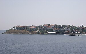
Amouliani
| Amouliani | ||
|---|---|---|
| Waters | Aegean Sea | |
| Geographical location | 40 ° 19 '30 " N , 23 ° 55' 13" E | |
|
|
||
| length | 6 km | |
| width | 3.5 km | |
| surface | 12 km² | |
| Highest elevation | 90 m | |
| Residents | 547 (2011) 46 inhabitants / km² |
|
| main place | Amouliani | |
Amouliani ( Greek Αμουλιανή , ( f. Sg. ) Or Ammouliani Αμμουλιανή, pronunciation : [ amuljaˈni ]) is an inhabited Greek island in the Singitian Gulf in the northern Aegean . It has an area of approx. 12 km² with a maximum length of 6 kilometers and a maximum width of up to 3.5 kilometers. In 2011 there were 529 permanent residents on the island, making it the only inhabited island in the Chalkidiki regional district and at the same time the largest island in terms of area of the islands around the Chalkidiki peninsula. With belonging to her two Drenia Islands Penna and Artemis Amouliani forms the municipality Amouliani (Δημοτική Κοινότητα Αμμουλιανής) in the municipality of Stagira-Acanthus (Δημοτική Ενότητα Σταγίρων-Ακάνθου) of the community Aristotelis .
Amouliani is located in the north of the Singitian Gulf (Gulf of Agion Oros) about 2.5 km south (3.5 km in relation to the place and port Amouliani) its northernmost point on the coast of the small settlement Trypiti. The settlement of Ouranoupoli is located approx. 3 km east of the southern tip of Amouliani and approx. 5 km southeast of the village of Amouliani. The distance to Thessaloniki in the north-west is approx. 90 km as the crow flies, to the Greek capital Athens the distance as the crow flies is approx. 260 km. The next point of the Sithonia peninsula to the west of Amouliani is the island of Diaporos near Vourvourou at a distance of approx. 15 km.
The island's longitudinal axis runs from northwest to southeast, with the width of the island tapering considerably from northwest to southeast. The island therefore has the rough shape of a triangle pointing downwards to the right with its apex with unequal sides: the distance from the northernmost point to the southernmost point of its west coast is approx. 6 km longer than the distance from the northernmost point to the southernmost point of its east coast approx. 4 km. The north of the island is formed by a coast running about 3 km from west-southwest to east-northeast, while Amouliani ends in a narrow peninsula in the south. Therefore Amouliani has its greatest latitude in the north between the western Cape Kokino and the eastern Cape Trigona. On the north east coast of the island is the only place and port on the island: Amouliani. The narrowest part of Amouliani is 1.4 km south of the village and is bordered by Alikes Beach in the west and Glastri Beach in the east. The two Drenia islands Penna and Artemis lie in the longitudinal axis of the island Amouliani, which slopes further to the east, southeast of this and southwest of the village of Ouranoupoli : they are both uninhabited and many times smaller than Amouliani. Like the Drenia Islands, Amouliani has a flat terrain: no point on the island rises more than 90 m above sea level. At the narrowest point of the island in a west-east direction is the small Aliki lake: this salt lake is used for sea salt extraction, in which water is artificially supplied from the surrounding sea via a pipe.
The island of Amouliani has been inhabited in its current form since 1922. Greek refugees from the village of Pasaliman on the Marmara Sea , who had to leave Pasaliman as a result of the Greek defeat in the Greco-Turkish War in 1922 and the subsequent " population exchange " agreed in the Treaty of Lausanne in 1923 between Greece and Turkey , settled on Amouliani and founded the Main place. Before 1922 the island was used as an agricultural property by the monasteries of Athos, who grew figs, grapes and olives on Amouliani. The island was not electrified until 1973 .
The nearest airport is that of Thessaloniki . There are ferry connections to Amouliani from Trypiti and Ouranoupoli on the west coast of the Athos peninsula. Tourism is the main economic factor in Amouliani today. This increases the number of people on the island to up to 5000 in summer. There are several hotels, private accommodation and taverns in the village and on the beaches.
literature
- Car map Chalkidiki, Thasos, Thessaloniki. 1: 200,000. freytag & berndt. ISBN 3-85084-285-1
- Halkidiki 1: 150,000. Road Editions, Athens. ISBN 960-8481-90-2
- Macedonia 1: 250,000. Road Editions, Athens. ISBN 960-8481-18-X
- Chancellor, Peter; Neumeier, Andreas: Northern and Central Greece . 9th edition. Michael Müller Verlag, Erlangen 2007. ISBN 978-3-89953-297-5
- Neumeier, Andreas: Chalkidiki . 4th edition. Michael Müller Verlag, Erlangen 2006. ISBN 3-89953-256-2
Web links
Individual evidence
- ↑ Results of the 2011 census at the National Statistical Service of Greece (ΕΛ.ΣΤΑΤ) ( Memento from June 27, 2015 in the Internet Archive ) (Excel document, 2.6 MB)


