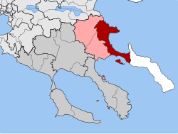
Stagira-Akanthos
|
Parish of Stagira-Akanthos Δημοτική Ενότητα Σταγίρων-Ακάνθου (Στάγιρα-Άκανθος) |
||
|---|---|---|
|
|
||
| Basic data | ||
| State : |
|
|
| Region : |
Central Macedonia
|
|
| Regional District : | Chalkidiki | |
| Municipality : | Aristotelis | |
| Geographic coordinates : | 40 ° 24 ' N , 23 ° 53' E | |
| Height above d. M .: | 0 to 916 m coast to Mount Stratonikio |
|
| Area : | 253.237 km² | |
| Residents : | 6,063 (2011) | |
| Population density : | 23.9 inhabitants / km² | |
| Code No .: | 130202 | |
| Structure: |
2 city districts 6 local communities |
|
| Located in the Aristotelis municipality and in the Halkidiki regional unit | ||
Stagira-Akanthos ( Greek Στάγιρα-Άκανθος ; ( n. Pl. ), ( F. Sg. )); official name Dimotiki enotita Stagira-Akanthos (Δημοτική Ενότητα Σταγίρων-Ακάνθου), has been a district of the Greek community of Aristotelis in the Central Macedonia region since 2011 . It was created in 1997 as an independent municipality from the amalgamation of the municipalities of Ierissos , Stagira , Ouranoupoli , Ammouliani , Stratoniki , Stratoni , Nea Roda and Olymbiada as part of the Greek local government reform Schedio Kapodistrias . The name is derived from the two ancient cities ( poleis ) in the area of the municipality: Stageira near today's village of Olymbiada and Akanthos near today's village of Ierissos.
For the structure in localities and settlements see Aristotelis # Gemeindegliederung .
literature
- Halkidiki 1: 150,000. Road Editions, Athens. ISBN 960-8481-90-2
- Macedonia 1: 250,000. Road Editions, Athens. ISBN 960-8481-18-X
- Chancellor, Peter; Neumeier, Andreas: Northern and Central Greece . 9th edition. Michael Müller Verlag, Erlangen 2007. ISBN 978-3-89953-297-5
Individual evidence
- ↑ Results of the 2011 census, Greek Statistical Office (ΕΛ.ΣΤΑΤ) ( Memento from June 27, 2015 in the Internet Archive ) (Excel document, 2.6 MB)

