Potidea Canal
| Potidea Canal (Διώρυγα της Ποτίδαιας) | |
|---|---|
| location | Greece , Chalkidiki , Kassandra |
| length | 1,100–1,250 m |
| Built | 315 BC Chr. (?) |
| Expanded | 1930 |
| Beginning | 40 ° 11 ′ 47 "N, 23 ° 19 ′ 18" E |
| The End | 40 ° 11 ′ 48 "N, 23 ° 19 ′ 59" E |
| Descent structures | no |
| Ports | Nea Potidea |
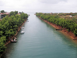
| Potidea Canal (from the east) | |
The Potidea Canal ( Greek Διώρυγα της Ποτίδαιας , Dioryga tis Potideas ; alternative transcription of the Poteidaia Canal ) is an artificially created and navigable canal on the Chalkidiki peninsula of the Greek administrative region of Central Macedonia .
geography
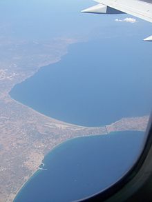
The canal leads at the narrowest point of the isthmus of the Kassandra peninsula immediately north of the town of Nea Potidea from the Thermaic Gulf in the west to the Toronean Gulf ( Gulf of Kassandra ) in the east and thus separates the Kassandra peninsula (1st 'finger') from the rest of the peninsula Chalkidiki ('palm of the hand').
The channel has a length of 1,100 to 1,250 m (depending on the source) and an average width of 40 m at the water surface. The western entrance of the channel is located at position 40 ° 11 '47 " N , 23 ° 19' 18" O , the eastern entrance of the channel is located at position 40 ° 11 '48 " N , 23 ° 19' 59" O . The mean depth of the channel is 4.5 m, the fluctuation range of the depth is 3.5 to 5.5 m. In 1975 the minimum depth of the canal was 2.8 m. The water depths in front of the western entrance to the canal are already 35 m a short distance from the western entrance. In front of the eastern entrance, the water depth for 2 to 3 km is only up to 5 m; then the sea floor then drops to depths of 38 m and beyond.
The tidal range on the Potidea Canal is 25 cm. Water flows through the Potidea Canal at a rate of 18 to 35 cubic meters per second. The flow of water is observed both in a westerly direction (in the thermal gulf) and in an easterly direction (in the Torona gulf) and is caused by the tidal range and wind power.
history
The history of the origins of the ancient canal is not fully understood. Strabo mentioned the canal in the 1st century AD. Accordingly, the canal of Potidea was built by the Macedonian king Kassander at the same time as the city of Kassandreia, south of Potidea, was founded in 315 BC Built.
When describing the siege of Potidea by the Persian forces under Artabazos 480–479 BC. The channel was not mentioned by Herodotus . Nor does Thucydides describe the canal in his work on the Peloponnesian War in his report on the siege of Potidea by Athens in 432-430 BC. Further sources to confirm its existence from the end of the 4th century BC. Do not exist.
A comparable ancient canal from the 5th century BC. The Xerxes Canal was on the Athos Peninsula, 55 km to the east.
In 1407 the Byzantine Emperor Manuel II Paleologos had the canal securely dug again and at the same time fortifications built on its south side. In 1423 the Venetians took over Thessaloniki and the Potidea Canal including Cassandra. Despite the military security measures, the canal with Thessaloniki and the Kassandra peninsula fell to the Ottoman Empire in 1430 . During the Ottoman occupation, no precise information about the condition and use of the canal has survived.
As part of the Greek War of Independence from 1821 to 1829, the canal was dug again in 1821 and at the same time the fortifications on the south bank from the Byzantine era were rebuilt. In contrast to the Peloponnese and southern Greece, the insurgents on the Chalkidiki peninsula did not have any lasting military success. As early as 1821, after successful counter-attacks by the Ottoman army on the Kassandra peninsula, the Greek rebels withdrew behind the canal and the fortress wall on its south bank. According to tradition that was not unequivocally certain, the Ottoman army succeeded in overcoming the hurdle of the canal by laying bales of sheep's wool, conquering the fortress wall of Potidea and subsequently defeating the rebels. During the first Balkan War, there were no military conflicts on the Potidea Canal.
In 1930 the canal was dug again. In contrast to the course up to 1930, which described an arc from northwest to east, the canal was excavated or repaired in a straight line from west ( Thermaic Gulf ) to east (Toronean Gulf). Until 1970 the Kassandra peninsula could only be reached by ferry; the commissioning of the bridge on the Nea Moudania - Kallithea road made the ferry redundant. Since the beginning of the 21st century, another bridge has been running parallel to the road bridge from 1970 across the Potidea Canal. Both bridges are used as separate carriageways on a four-lane expressway from Nea Moudania to Kallithea or Kassandria. There are no other bridges over the canal.
use
In ancient times, the canal was a great relief for the rather coastal navigation. The bypass of the Kassandra peninsula, for example to reach Thessaloniki from Byzantium by ship, was eliminated by the canal. In the Middle Ages and especially in the modern age, the importance of the canal decreased with increasing seaworthiness of the ships, especially since the time saved by omitting the circumnavigation of the Kassandra peninsula with the use of ship engines decreased. At the present time, the Potidea Canal is mainly used by local and regional fishermen to take their Kaika- type ships from the thermal to the Toronic Gulf over a short distance . The use of the canal is limited to smaller ships anyway due to its size in terms of width and depth.
literature
- Strabo (Ed. Horace Leonard Jones): The Geography of Strabo . Harvard University Press, Cambridge 1924.
- Ioakim A. Papangelos: Chalkidiki. Greece . 3. Edition. Malliaris-Paidia, Thessaloniki 1987, ISBN 0-86190-200-9 .
- Établissement Principal du Service Hydrogéographique et Océanographique de la Marine. Cote Est de Grece. De Evvoïkós Kólpos (partie north) à Kólpos Kaválas . 1: 250,000. BP 30316-29603, Brest Cedex 2005.
- Klaus Bötig : Marco Polo Chalkidiki. Travel with insider tips. 7th edition. MairDumont, Ostfildern 2006, ISBN 3-8297-0116-0 .
Web links
Individual evidence
- ↑ a b c d e Ioakim A. Papangelos. Chalkidiki. Greece. 3. Edition. Malliaris-Paidia Publishing House, Thessaloniki 1987.
- ↑ a b c Y. G. Savvidis, CG Koutitas, and YN Krestenitis. Modeling the water mass exchange through navigational channels connecting adjacent coastal basins - application to the Channel of Potidea (North Aegean Sea). Annales Geophysicae (2005) 23: 231-238
- ^ A b Établissement Principal du Service Hydrogéographique et Océanographique de la Marine. Cote Est de Grece. De Evvoïkós Kólpos (partie north) à Kólpos Kaválas. 1: 250,000. BP 30316-29603, Brest Cedex. 2005.
- ↑ NOTE: The ISBN is only valid for the edition published by Moorland Publishing on April 30, 1987. The original book by Malliaris-Paidia does not have an ISBN.
Coordinates: 40 ° 11 ′ 48 ″ N , 23 ° 19 ′ 39 ″ E


