Chania (regional unit)
|
Chania Regional Unit Περιφερειακή Ενότητα Χανίων (Χανιά) |
|
|---|---|
| Basic data | |
| State : | Greece |
| Region : | Crete |
| Area : | 2,376 km² |
| Residents : | 156,585 (2011) |
| Population density : | 65.9 inhabitants / km² |
| NUTS 3 code no. : | EL434 |
| Structure: | 6 municipalities |
| Website: | www.nax.gr |
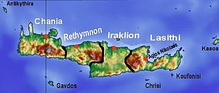
The regional district of Chania comprises the west of the Greek island and region of Crete and is named after its center, the city of Chania . From 1915 to 2010 it had the status of a prefecture, since 1997 self-administered. The area of today's municipality of Sfakia came to Chania from the Rethymno prefecture in 1925. With the Greek administrative reform in 2010 , the prefecture was abolished, the competences were divided between the region and the numerically greatly reduced municipalities. The regional district of Chania sends 13 members to the Cretan regional council, but beyond that it no longer has any political significance.
geography
Topographically , the regional district covers the entire western part of Crete up to the eastern foothills of the White Mountains ( Lefka Ori ). The small island of Gavdos , which represents the southernmost point of Europe, also belonged to the prefecture of Chania as the well-known Samaria Gorge .
It is divided into the parishes Apokoronas , Chania , Gavdos , Kandanos-Selino , Kissamos , Platanias and Sfakia .
Web links
Individual evidence
- ↑ Results of the 2011 census at the National Statistical Service of Greece (ΕΛ.ΣΤΑΤ) ( Memento from June 27, 2015 in the Internet Archive ) (Excel document, 2.6 MB)
- ↑ On the history of the prefecture of Chania (Greek)

