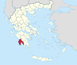
Messenia (regional district)
|
Messinia Regional Unit Περιφερειακή Ενότητα Μεσσηνίας (Μεσσηνία) |
|
|---|---|
| Basic data | |
| State : | Greece |
| Region : | Peloponnese |
| Area : | 2,991 km² |
| Residents : | 159,954 (2011) |
| Population density : | 53.5 inhabitants / km² |
| NUTS 3 code no. : | - |
| Structure: | 6 municipalities |
The regional district of Messenia ( Greek Μεσσηνία , Messinía ) is one of the five regional districts of the Greek region of Peloponnese . It essentially comprises the ancient landscape of Messenia in the southwest of the Peloponnese . The center is Kalamata .
After the founding of modern Greece, Messenia was a prefecture (gr. Nomos νομός) of the country from 1833 , which it remained almost uninterrupted until 2010. With the Greek administrative reform in 2010 , their competencies were transferred to the municipalities, which had been greatly reduced in number by merging, and the Peloponnese region ; Since then, the area has had the status of a regional district, which, however, apart from the allocation of seats for the regional council, has no political significance.
geography
The heart of the Messinia landscape on the Messinian Gulf is the Pamisos river valley and its tributaries, an area that used to be called Stenyklaros and which is the most densely populated part of Messenia. It is an extremely fertile landscape, where oranges , lemons , almonds , figs and olives are grown in large quantities and of good quality to this day. This river level is limited in the north by the Nomian Mountains (today: Tetrási, 1570 m), in the west by the Kyparissia Mountains (around 950 m), while in the east the Taygetos Mountains form the border with the Evrotas Valley, in which Sparta lies. The Oinussai Islands are located off the southwest coast of the Peloponnese . Messenia, despite its long coastline, has few good ports and therefore did not play a major role in Greece's maritime history. Only Pylos in the southwest was of any importance. By Greek standards, Messinia is a water-rich and at the same time warm, fertile region in which fruits and vegetables are grown, also for export.
traffic
- National Road 7 , N, Zen.
- National Road 9 , NW, W, SW
- National Road 9a , NW, N
- National Road 82 , SW, Zen., SE
Administrative division
The subdivision of Messenia into provinces (Ez. Gr. Eparchia ) changed from time to time. When it was founded in 1833, the province of Olympia still belonged to Messenia, which later became part of the Prefecture of Elis . Trifylia formed the independent prefecture of Trifylia with the province of Olympia from 1899 to 1909; During this time the Western Mani was subordinate to the short-lived Lakoniki Prefecture. The provinces were abolished as part of the 1997 Greek municipal reform.
Provinces before 1997:
- Kalamata Province - Kalamata
- Province of Messini - Messini
- Province of Pylia - Pylos
- Trifyllia Province - Kyparissia
The 280 municipalities to date were merged into 31 in 1997, with the administrative reform in 2010 these municipalities were merged into six municipalities that are similar in size to the former provinces. The 280 old communities elect local representatives as districts or local communities.
- Municipalities since 2010
Individual evidence
- ↑ Results of the 2011 census at the National Statistical Service of Greece (ΕΛ.ΣΤΑΤ) ( Memento from June 27, 2015 in the Internet Archive ) (Excel document, 2.6 MB)
