Messenian golf
| Messenian golf | |
|---|---|
|
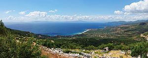
Panorama over the Messenian Gulf, looking northwest, Messenia in the background |
|
| Waters | Ionian sea |
| Land mass | Peloponnese |
| Geographical location | 36 ° 50 ′ N , 22 ° 4 ′ E |
| width | approx. 35 km |
| depth | approx. 35 km |
| Tributaries | Pamisos |
The Messenian Gulf ( Greek Μεσσηνιακός Κόλπος Messiniakos Kolpos ) is located in the southeastern Ionian Sea and separates the two western fingers of the Peloponnese, Messenia and Mani . The northern end is relatively densely populated with the cities of Kalamata and Messini , as is the western side, which attracts tourists with many sandy beaches. The eastern coast is characterized by the southern foothills of the Taygetos Mountains and in many places drops steeply into the sea. Correspondingly inaccessible and barren is this stretch of coast, where there are only a few larger places, such as Kardamyli ,Stoupa and Areopoli or its port Limeni. The largest tributary of this marine area is the Pamisos , which flows into the sea at Kalamata.

