
Areopoli
|
Local community Areopoli Αρεόπολη (Τοπική Κοινότητα Αρεοπόλεως) |
|||
|---|---|---|---|
|
|||
| Basic data | |||
| Country |
|
||
| region | Peloponnese | ||
| Regional district | Laconia | ||
| local community | Anatoliki Mani | ||
| Parish | Itylo | ||
| Geographic coordinates | 36 ° 40 ′ N , 22 ° 23 ′ E | ||
| Height above d. M. |
242 m (average) |
||
| surface | 15.169 km² | ||
| Residents | 1014 (2011) | ||
| LAU-1 code no. | 43020301 | ||
| Local division | 6th | ||

Areopoli ( Greek Αρεόπολη ( f. Sg. )), Formerly also called Areopolis and Tsimova, is the capital of the Mani peninsula and forms a local community with five smaller villages in the municipality of Itylo in the municipality of Anatoliki Mani in the Greek region of Peloponnese .
location
Areopoli is located around 80 kilometers south of Kalamata at an altitude of 255 meters on a plateau between the Messenian Gulf (Messiniakos Kolpos) and the Taygetos Mountains. With 888 inhabitants (2011) Areopoli is the largest town in western Mani. It is located on the border between the Outer Mani (Éxo Mani) , which extends from Areópoli to just before Kalamata, and the Inner Mani (Méssa Mani) , as the area south of Areopoli to Cape Tainaron is called. At this point the Taygetos is relatively flat and therefore offers a relatively cheap way to the east, to the port city of Gythio . This pass was secured in the Turkish times by the fortress Kelefá .
History and cityscape
.svg)
Areópoli probably received the name "Aresstadt" in honor of the god of war Ares .
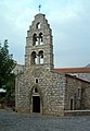
A monument was erected on the market square to the freedom fighter Petros Mavromichalis (1765–1848), whose powerful family had lived on the Mani for centuries. He hoisted the Mani flag (with a blue cross and the slogan ΝΙΚΗ Ή ΘΑΝΑΤΟΣ "Victory or Death") on March 17, 1821, together with other maniots , on the historic church of the Taxiarches , giving the starting signal for the Greek struggle for freedom .
The port of Areopoli is Limeni with the family seat of the Mavromichalis , which today serves as a museum for the customs of the Mani.
The city is characterized by the residential towers typical of the peninsula and by churches worth seeing and is a listed building .
Double church of Panagia and Agios Charalambos

Tower of the Ag. Taxiarchoes

Monument to Petros Mavromichalis in the main square
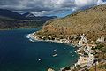
Limeni and Limeni Bay

Limeni Bay in the background is Areopoli


Pyrgos Dirou caves
About seven kilometers south of Areopoli is the stalactite cave near Pyrgos Dirou ( Greek Σπήλαια του πύργου διρού ), the most visited attraction of the Mani. An underground boat trip takes visitors into the effectively illuminated cave system.
Individual evidence
- ↑ National Statistical Service of Greece (ΕΣΥΕ) according to 2001 census , p. 48 (PDF, 793 kB)
- ↑ Results of the 2011 census, Greek Statistical Office (ΕΛ.ΣΤΑΤ) ( Memento from June 27, 2015 in the Internet Archive ) (Excel document, 2.6 MB)