Zirler Berg
| Zirler Berg | ||
|---|---|---|
|
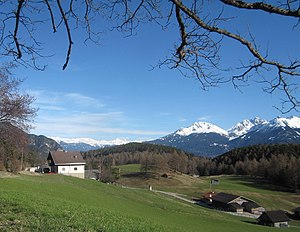
View from the Seefeld plateau to the southeast to the wooded Zirler Berg (center); in front of it between the houses the plague column of Leithen ; in the back right the Marchreisenspitze , to the left of it the Saile ; to the left on the horizon the Tux Alps |
||
| height | 1057 m above sea level A. | |
| location | near Zirl ; Innsbruck-Land District , Tyrol ( Austria ) | |
| Mountains | Karwendel | |
| Dominance | 0.53 km → Durschkopf | |
| Notch height | 57 m ↓ southeast of Leithen | |
| Coordinates | 47 ° 17 '7 " N , 11 ° 13' 29" E | |
|
|
||


The Zirler Berg near Zirl in the Austrian state of Tyrol is 1057 m above sea level. A. high southern foothills of the Reither Spitze ( 2374 m ) in the Karwendel , a western part of the Northern Limestone Alps . It is best known for the Seefelder Straße (B 177), which on its southern slope overcomes a height difference of less than 4 kilometers between Zirl in the Inn Valley and Leithen on the Seefeld Plateau .
Geographical location
The Zirler Berg is located on the south- eastern foothills of the Seefeld Plateau at about 1200 m above sea level , which extends between Wetterstein - (north), Karwendel - (east) and Mieminger Gebirge (west) and drops in the south to the Inn Valley 600 m below . Its hilltop is located southeast of Reith and its district Leithen in the Zirler Forest , which also covers the valley slope down to the Tiroler Straße (B 171) between Zirl and Telfs .
About 2.5 km north of the Zirler mountain rises the Rauen head ( 2,011 m ) of the north of it located Reither Spitze ( 2,374 m ) via conducting, and about 2.5 km northeast of the Brunstkopf ( 1719 m ), all at the Erlspitze Group include . Passing eastwards through the Schlossbachklamm the Inn tributary Schlossbach flows . A plague column has stood a little north of the hilltop since 1637 on the outskirts of Leithen .
geology
The summit of the Zirler Berg and its southern mountain flank towards the Inn valley consists of layers of the main dolomite , in the area of the mountain top there are moraine deposits.
traffic
Zirlerbergstrasse
On the south and east face of the mountain of the Zirler also leads Zirlerbergstraße said portion of Seefeld Road (B 177) which are predominantly in the south-north direction from the Inntal of Zirl ( 622 m ) on the mountain coming up to 16% gradient uphill leads to Leithen ( 1010 m ) and then on through Reith, whose district Auland and over the Seefelder Sattel ( 1185 m ) located about 4 km (as the crow flies ) northwest of the Zirler Berg to Seefeld ; thus the road between Zirl and Leithen overcomes 388 m difference in altitude, although the terrain continues to rise in the direction of the Seefelder saddle.
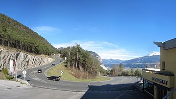
On the southern flank of the Zirler Berg - at the Zirlerberg-Rast inn with a view of the Inn Valley - lies the only hairpin on the Zirlerbergstrasse at an altitude of around 818 m .
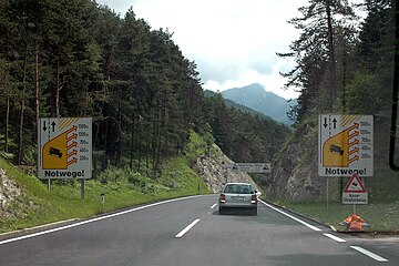
The Seefelder Straße is closed between Zirl and Reith in a north direction (uphill) for cars with trailers and on the entire route between Zirl and Scharnitz in both directions for trucks over 7.5 tons, certain destination and source traffic is excluded. An earlier approval for certain car trailers was canceled in 2007. Due to the steep gradient, several emergency routes have been laid out between Leithen and Zirl , which branch off from the downhill lane into the Inn Valley ; As emergency braking routes located on the mountain slope, they lead uphill a bit, so that trucks in particular can be braked in an emergency in their gravel path beds. Because of the gradient, cycling is also prohibited downhill; You can cycle uphill.
Karwendelbahn
A part of the winding and tunnel-rich Karwendelbahn , the railway line leading from Innsbruck via Seefeld and Mittenwald to Garmisch-Partenkirchen, runs northeast past the Zirler Berg along the B 177 . A little east of the mountain, it is laid out as an elongated bend with bridges and tunnels in the south flank of the Rauenkopf and southwest flank of the Brunstkopf, crossing the Schlossbach .
Energy generation
In 2005, Austria's first sewage power plant was built on the Zirler Berg for the new sewage treatment plant in Seefeld . The clarified water is no longer diverted to the Isar, but is pumped to the Zirler Berg and the gradient to the Inntal is used to operate a turbine . Of the 5.5 million kilowatt hours of annual working capacity, 0.5 is used for wastewater treatment and 1.5 for the pumping station, so that the net generation of 3.5 GWh roughly corresponds to the needs of all private households in Seefeld.
Individual evidence
- ↑ a b c d e Federal Office for Metrology and Surveying (BEV): Topographic map of Austria on AMAP online
- ^ Geological map of the Republic of Austria , 1: 50,000; Bl. 117, Zirl (1992), on opac.geologie.ac.at (PDF; 2.1 MB)
- ↑ Ordinances No. 1365 and 1366 on driving bans on the B177 Seefelder Straße , in the Bote für Tirol - Official Gazette of the Authorities, Offices and Courts of Tyrol , Bl. 51/188, from December 19, 2007, on tirol.gv.at (PDF; 128 kB), p. 606
- ↑ ... Ordinance on the truck driving ban on the B177 Seefelder Straße (Zirler Berg) , at the Federal Association of Goods Transport, Logistics and Disposal (BGL) e. V. , Bl. 010-08, from December 13, 2007, on archiv.vv-suedbaden.de (PDF; 455 kB)
- ↑ Power Plobb, the Seefeld iT sewage power plant ( Memento from February 1, 2014 in the Internet Archive ), website of Wasser Tirol GmbH ( TIWAG subsidiary)
Web links
- Excerpt from the film Ja, ja, die Liebe in Tirol from 1955 with the hairpin of the Zirler mountain (YouTube video)
- Zirler Berg B 177 ... , course of the road from Leithen to Zirl, uphill (YouTube video)

