
Reither tip
| Reither tip | ||
|---|---|---|
 View from the south of the Reither Spitze and the Nördlinger Hut |
||
| height | 2374 m above sea level A. | |
| location | Tyrol , Austria | |
| Mountains | Erlspitz group , Karwendel | |
| Dominance | 3.7 km → Erlspitze | |
| Notch height | 278 m ↓ original saddle | |
| Coordinates | 47 ° 19 '23 " N , 11 ° 14' 10" E | |
|
||
| rock | dolomite | |
| Normal way | From the Nördlinger Hut | |

The Reither Spitze is a mountain in the Karwendel in the Austrian state of Tyrol , which is primarily known as a vantage point due to its location at the south-western end of the Erlspitz group . The Reither Spitze takes its name from the village of Reith bei Seefeld , which is located at the southwestern foot of the Reither Spitze.
Ascent
From the Nördlinger Hütte to the south of the summit, the Reither Spitze can be reached in 20 minutes on a path. The Nördlinger Hütte can be reached in one hour from the cable car mountain station to the northwest below the Härmelekopf ( 2224 m above sea level ); From the Härmelekopf, however, you can also reach the Reitherspitze directly over the Reither Joch (sure-footedness required). The approach from Reith bei Seefeld and Seefeld takes about three hours each. From the Seefelder Spitze ( 2221 m above sea level ) the Reither Spitze can be reached via a simple path (sure-footedness required) or directly via the connecting ridge, the climbing in lower III. Requires level of difficulty .
geology
The summit of the Reither Spitze and the ridge to the Seefelder Spitze are built from rocks from the main dolomite . This zone of the upper main dolomite is ring-shaped by a zone of the oily and partially fossil-bearing Seefeld strata . Due to fish fossils, oily slates from this area are also referred to as ichthyol slate after the ancient Greek word for fish ichthys (ἰχθύς) . These rocks were mined for the extraction of ichthyol in various places around the Reither Spitze. The main mining area was located at the foot of the Reither Spitze, southeast of Seefeld in the area of the Reither Jochalm .
Reither tip from Seefeld

Härmelekopf and Reither Spitze in winter

View from the foot of the Hohe Munde

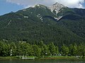
Härmelekopf, Reither Spitze, Nördlinger Hut, view from Wildsee


.JPG)

Web links
swell
- ^ Heinrich Klier, Fritz March: Alpenvereinsführer Karwendelgebirge , Verlag Rudolf Rother , 12th edition, Munich 1984, ISBN 3-7633-1200-5 , p. 136.
- ^ Heinrich Klier, Fritz March: Alpenvereinsführer Karwendelgebirge , Verlag Rudolf Rother, 11th edition, Munich 1978, ISBN 3-7633-1208-0 , p. 131.
- ↑ Mapping report of the Federal Geological Institute, as of March 14, 2009 (PDF; 243 kB)
- ^ Geological map of the Republic of Austria 1: 50,000, sheet 117 Zirl, Geologische Bundesanstalt Wien 1992.