
Marchreisenspitze
| Marchreisenspitze | ||
|---|---|---|
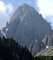
 From the north: to the right of the center of the picture the Marchreisenspitze, to the left the Ampferstein , in between the Kehlbachlspitzen |
||
| height | 2620 m above sea level A. | |
| location | Tyrol , Austria | |
| Mountains | Kalkkögel , Stubai Alps | |
| Dominance | 2.2 km → Steingrubenkogel | |
| Notch height | 219 m ↓ Malgrubenscharte | |
| Coordinates | 47 ° 10 ′ 21 ″ N , 11 ° 18 ′ 30 ″ E | |
|
||
| rock | Main dolomite | |
| Age of the rock | Norium | |
| First ascent | June 26, 1879 by Carl Gsaller (tourist) | |
| Normal way | Funny mountain climbing path | |

The Marchreisenspitze is with 2620 m the fifth highest peak in the Kalkkögel in the Stubai Alps . Together with the Ampferstein and the Malgrubenspitze , it forms the well-known “triumvirate” above the Axamer Lizum , which is clearly visible as far as the Inn Valley .
Climbs
The most popular ascent option is the Funny Bergler Steig , an easy via ferrata that leads from the Halsl via the Ampferstein to the Marchreisenspitze. From the Ampferstein you first climb on the south side past the Kehlbachlspitzen, before the trail leads into the southern flank of the Marchreisenspitze. You finally reach the summit through a gravelly gorge and a few bands.
There is another ascent from the Gsallerweg through the southwest flank.
Finally, there are still a few variants of descent, for example through the large gravel crack into the Lizum or south into the Schlick .
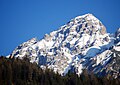
photos

From the southwest
From the north from the Axamer Lizum
From the southeast

with a view towards the Inn Valley

with a view towards Schlick

Shortly before the summit of the Marchreisenspitze


literature
Walter Klier: Alpine Club Guide Stubai Alps Alpine . 13th edition. Bergverlag Rudolf Rother , Munich 2006, ISBN 3-7633-1271-4 , p. 446 .
Web links
- Tour description Marchreisenspitze on meinstubaital.at