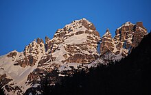
Steingrubenkogel
| Steingrubenkogel | ||
|---|---|---|
|
View from the Senderstal: Steingrubenkogel to the left of the center of the picture, followed by Schlicker Nadeln and Alpenklubscharte to the right |
||
| height | 2633 m above sea level A. | |
| location | Tyrol , Austria | |
| Mountains | Kalkkögel , Stubai Alps | |
| Dominance | 0.8 km → Great Ochsenwand | |
| Notch height | 182 m ↓ Alpenklubscharte | |
| Coordinates | 47 ° 9 '52 " N , 11 ° 16' 45" E | |
|
|
||
| rock | Main dolomite | |
| Age of the rock | Norium | |
| First ascent | September 4, 1883 by Ludwig Purtscheller (tourist) | |
| Normal way | East ridge ( I ) | |
The Steingrubenkogel is at 2633 m above sea level. A. the fourth highest peak of the Kalkkögel in the Stubai Alps . As a striking cone south of the Hoadlsattel , it can be easily identified both by its shape and by the neighboring Alpenklubscharte to the south .
Climbs
The most frequently used variant is the marked trail from the south and east, known for short as "Ostgrat", the beginning of which can be reached from both the Gsallerweg and the Alpenklubscharte via the Nadelscharte . The trail includes minor climbs in difficulty UIAA I .
The south-west ascent ("west ridge") from the Alpenklubscharte is also very popular. The path, secured in places with wire ropes, leads past several needles over ribbons, cracks and small chimneys, finally over Schrofen to the summit. Here are some passages from UIAA II.
The other climbs, including a variant to the west ridge and the north flank of the Steingrubenscharte, are more difficult.
literature
Walter Klier: Alpine Club Guide Stubai Alps Alpine . 13th edition. Bergverlag Rudolf Rother, Munich 2006, ISBN 3-7633-1271-4 , p. 446 .
Web links


