Schneiderspitze (Kalkkögel)
| Tailor | ||
|---|---|---|
|
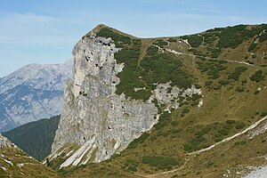
The tip of a tail from the southwest |
||
| height | 2156 m above sea level A. | |
| location | Austria Tyrol | |
| Mountains | Stubai Alps | |
| Dominance | 0.4 km → Ampferstein | |
| Notch height | 29 m ↓ Scharte to the Ampferstein | |
| Coordinates | 47 ° 11 '6 " N , 11 ° 18' 29" E | |
|
|
||
| rock | dolomite | |
| Age of the rock | Triad | |
The Schneiderspitze is a summit in front of the Ampferstein in the Kalkkögeln , part of the Stubai Alps .
To the north and west, the Schneiderspitze slopes down towards the Axamer Lizum with its imposing rock faces . The lower rock face is called the hut wall . The summit can be reached on easy climbs, either from Lizumer Kar in the west or from Halsl 1992 m in the east, the saddle between the Ampferstein and the Nockspitze . In winter, the Schneiderspitze is also a destination for ski tourers . The ascent from the Axamer Lizum over the Halsl takes around 1.5 hours to walk.
Individual evidence
- ^ Rudolf Weiss: Skitouren Stubai Alps , Steiger Verlag, Berwang 1986, ISBN 3-85423-035-4 , page 42.

