
Schlicker Seespitze
| Schlicker Seespitze | ||
|---|---|---|
 Schlicker Seespitze from the west |
||
| height | 2804 m above sea level A. | |
| location | Tyrol , Austria | |
| Mountains | Kalkkögel , Stubai Alps | |
| Dominance | 3.6 km → Schwarzhorn | |
| Notch height | 327 m ↓ Sendersjöchl | |
| Coordinates | 47 ° 8 '44 " N , 11 ° 16' 24" E | |
|
||
| rock | Main dolomite | |
| Age of the rock | Norium | |
| First ascent | July 13, 1879 by Carl Gsaller | |
| Normal way | West flank ( I ) | |

The Schlicker Seespitze is 2804 m above sea level. A. the highest peak of the Kalkkögel in the Stubai Alps , at the same time also the southwest corner pillar of the Kalkkögel chain. Known to be extremely brittle, the mountain is a good vantage point. From the Schlicker side it presents itself as a rugged rock massif with a massive south ridge on which the rock towers of the Schlicker Manndln sit, from the other side as a brittle, torn elevation above the gravel journeys . The detached Seejochturm above the Seejöchl is striking.
Climbs
From the Seejöchl (access from the Adolf-Pichler-Hütte or from the Schlick ), a well-marked trail of difficulty I (UIAA) leads through gravelly terrain up to the Seespitzscharte between Seespitze and Riepenwand , over the north ridge and over it briefly to the summit. Please note the danger of falling rocks that you are exposed to during the entire ascent.
In addition, there are several alpine climbing routes up to difficulty level VII +, some of which were developed by well-known alpinists such as Ludwig Purtscheller , Andreas Orgler and Mathias Rebitsch . Popular is exceeded, the slip Manndln that leads from the slurry Schartl difficulty in IV to the peak.

At the summit with a view of the Schlick

At the summit with a view of the Schlicker See
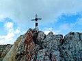
the small summit cross


literature
- Walter Klier: Alpine Club Guide Stubai Alps Alpine . 13th edition. Bergverlag Rudolf Rother, Munich 2006, ISBN 3-7633-1271-4 , p. 446 .
Web links
- Tour description Schlicker Seespitze on meinstubaital.at