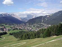
Seefeld plateau
Coordinates: 47 ° 20 ' N , 11 ° 12' E
The Seefeld Plateau is a low mountain range valley and basin landscape in the North Tyrolean Limestone Alps around 500 m above the Inn Valley in Tyrol , which includes the basins around Seefeld in Tyrol and Scharnitz as well as the Leutasch Valley .
Geographical location
The Seefeld plateau extends north from the Zirler Berg . It lies at an altitude of around 1200 m above sea level. A. in the North Tyrolean Limestone Alps between the Wetterstein Mountains in the northwest, the Mieminger Mountains in the west and the Karwendel in the east. The Seefelder Sattel ( 1185 m above sea level ), located on the plateau south of Seefeld, forms a valley watershed , north of which the plateau drains to the Isar , south to the Inn .
Geology and flora


The dominant rocks of the Seefeld plateau are Wetterstein limestone and main dolomite with bituminous slate in places . An arm of the Ice Age Inn Glacier has gouged out a number of tubs and left behind lakes such as the Wildsee , Möserer See or Wildmoossee, as well as numerous high moors such as the Reither Moor , which were created by the silting up of lakes.
The plateau lies in the montane height level . On the slopes there are fir-beech forests with added spruce . The bottom has been greatly shaped by people outside the towns predominate meadows on the type of oat reported that as hay meadows or pastures are used.
Economy and Transport
With around 1.74 million overnight stays per year, in equal parts in winter and summer (as of 2013), tourism is by far the most important branch of industry on the Seefeld plateau. The region has developed into a center of Nordic skiing and was the venue for the Nordic competitions of the Olympic Winter Games in 1964 and 1976 , the Nordic World Ski Championships in 1985 and 2019 and other major events. In summer the Karwendel is a magnet for hikers and mountain bikers.
The plateau is accessible via the Seefelder Straße (B 177) leading over the Seefelder Sattel and other state roads as well as the Karwendelbahn .
Planning association
The Seefeld plateau is relatively densely populated. The municipalities of Leutasch , Scharnitz , Seefeld in Tirol and Reith bei Seefeld form the planning association Seefelder Plateau of the State of Tyrol with 8651 inhabitants (as of January 1st, 2020) and an area of 300.44 km², of which 6.8% are permanent settlements. The four municipalities are marketed as a tourist region together with the Telfer villages of Mösern and Buchen under the name Olympiaregion Seefeld .
Web links
- Planning Association 14 - Seefelder Plateau , Land Tirol, on tirol.gv.at
- Seefelder Plateau , Tirol Atlas of the University of Innsbruck, on tirolatlas.uibk.ac.at
Individual evidence
- ^ A b Andrea Bucher, Wolfgang Hofbauer, Georg Gärtner: Contribution to the moss flora of Seefeld and the surrounding area and the Leutasch basin (North Tyrol). In: Reports of the scientific-medical association in Innsbruck. Volume 80, 1993, pp. 53-67 (PDF; 2.6 MB).
- ↑ a b Land Tirol: Region profile Seefelder Plateau - Statistics 2014 (PDF; 734 kB).
- ↑ Statistics Austria - Population at the beginning of 2002–2020 by municipalities (area status 01/01/2020)


