
Wildsee (Seefeld)
| Wildsee | ||
|---|---|---|

|
||
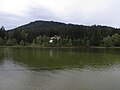
| Wildsee, seen from the north-west | ||
| Geographical location | Innsbruck-Land district , Tyrol , Austria | |
| Tributaries | Haglbach | |
| Drain | Seebach | |
| Places on the shore | Seefeld in Tyrol | |
| Data | ||
| Coordinates | 47 ° 19 '20 " N , 11 ° 11' 27" E | |
|
||
| Altitude above sea level | 1177 m above sea level A. | |
| surface | 6.1 ha | |
| length | 650 m | |
| width | 200 m | |
| volume | 78,500 m³ | |
| scope | 1.6 km | |
| Maximum depth | 5.1 m | |
| Catchment area | 6.9 km² | |

The Wildsee , sometimes also called Seefelder See or Seefelder Wildsee , is a lake near Seefeld in Tyrol . It has an area of 6.1 hectares and a maximum depth of 5.1 m. Most of the lake lies in the Seefeld municipality, the south and west banks belong to the municipality of Reith bei Seefeld .
It is fed by the Haglbach, which rises below the Seefelder Joch and flows into the southeast, as well as water from the Reither Moor and other smaller springs. Its catchment area is almost 7 km². The river flows north over the Seebach into the Isar . On the east bank of the lake there are smaller stocks of reeds and sedges , on the west bank the mixed forest reaches up to the lake. The Reither Moor extends south of the lake, an upland moor interspersed with mountain pines that emerged from the siltation of the Wildsee . In 1926 the lake was declared a natural monument. The south bank, together with the Reither Moor, is a nature reserve.
The Wildsee probably gave its name to Seefeld, which was first mentioned in 1022. Emperor Maximilian I used it for fish farming and had lamprets used, which is why the lake was also called Lampretensee. The breeding of the edible fish, which was popular at the time, only lasted for a few decades. Today the Wildsee is a popular bathing lake with two beaches. According to limnological studies, the lake has a low to moderate nutrient content. Due to the boggy character of the lake, the visibility is only about 1 to 3 m, the bathing water quality was classified as excellent in 2013.
The Wildsee is threatened with silting up by sediment input from the Haglbach. In the future, a pond dredged to the east of Innsbrucker Strasse is to take up these sediments. An enlargement of the Wildsee itself is also up for debate.
photos
The Wildsee towards the southwest with the Gschwandtkopf

View from the west bank to the lido

The frozen Wildsee in winter


Web links
Individual evidence
- ↑ a b c d e f State survey service: Depth map ( PDF; 1.4 MB )
- ↑ Federal Ministry of Health and Office of the Tyrolean Provincial Government: Bathing water profile Seefelder See, bathing establishment ( PDF; 2 MB )
- ^ Notburga Wahlmüller: Contributions to the vegetation history of Tyrol V: North Tyrolean Limestone Alps. In: Reports of the Natural Science and Medical Association in Innsbruck, Volume 72 (1985), pp. 101–144 ( PDF; 4.4 MB )
- ↑ Tyrolean protected areas: Reither Moor
- ↑ a b Seefelder Wildsee natural monument. In: Tiris . Retrieved February 18, 2016 .
- ↑ Land Tirol: Seefelder See
- ↑ Josef Hornsteiner: Last chance for the Wildsee? , plateauzeitung.at of February 4, 2014.