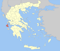
Kefallinia (prefecture)
|
Kefallinia Prefecture (1953-2010) Νομός Κεφαλληνίας |
|
|---|---|

|
|
| Basic data (April 2010) | |
| State : | Greece |
| Administrative region : | Ionian islands |
| Surface: | 904 km² |
| Residents: | 37,756 |
| Population density: | - |
| Prefectural seal : | |
| Capital: | Argostoli |
| Municipalities (δήμοι): | 8th |
| Rural communities (κοινότητες): | 1 |
| ISO-3166-2 code : | GR-23 |
| NUTS 3 code : | no NUTS region |
| License plate : | KE ( Ke fallinia) |
| Website : | www.na-kefalinia.gr |
Kefallinia ( Greek Κεφαλληνία Kefallinia ) was one of the four prefectures ( nomí νομοί) of the Greek administrative region of the Ionian Islands until 2010 . With the administrative reform of 2010 , the prefecture was dissolved and its powers were transferred to the Ionian Islands region and the newly allocated municipalities. Since then, the area has consisted of the two municipalities Kefalonia and Ithaka , which are also run as regional districts (Ez. Gr. Periferiaki enotita ), but apart from the allocation of seats in regional elections, they have no political significance.
The area of the prefecture emerged largely from the Ithaque department, which was founded under Napoleonic rule in 1797 and came to Greece as the prefecture of Kefallinia with the Republic of the Ionian Islands in 1864 . At that time Ithaca formed its own prefecture together with Agia Mavra (Lefkada), was attached to the prefecture of Kefallinia in 1866, but later administered again with Lefkada from 1899 to 1909 and 1946–1953. Since 1953 the prefecture consisted again of Kefalonia and Ithaca.
At that time it comprised 172 settlements in the three provinces of Krani, Paliki and Sami as well as the municipality of Ithaca, which is directly subordinate to the prefecture. With the municipal reform in 1997, the three urban and 76 rural municipalities were combined into a total of nine municipalities: The municipalities Argostoli , Elios-Pronni , Erisos , Ithaka , Livathos , Lixouri ("Paliki"), Pylaros and Sami and the rural municipality Omala .
Individual evidence
- ↑ The population figures come from a brochure of the Greek Ministry of the Interior from May 2010 on the occasion of the administrative reform under the 'Kallikratis Law': Elliniki Dimokratia, Ypourgeio Esoterikon, Apokendrosis ke Ilektronikis Diakyvernisis: "Programma Kallikratis", Systasi, syngrotisi Dimon, Periferion ke Apikokendromenon ti Nea Architektoniki tis Aftodiikisis ke tis Apokendromenis Diikisis, Athens 2010.
- ↑ History of Lefkada on the pages of the former prefecture (Greek)

