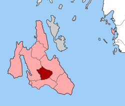
Omala
|
Omala parish Δημοτική Ενότητα Ομαλών (Ομαλά) |
||
|---|---|---|
|
|
||
| Basic data | ||
| State : |
|
|
| Region : |
Ionian islands
|
|
| Regional District : | Kefallinia | |
| Municipality : | Argostoli | |
| Geographic coordinates : | 38 ° 10 ′ N , 20 ° 36 ′ E | |
| Height above d. M .: | 410 m average |
|
| Area : | 46.699 km² | |
| Residents : | 840 () | |
| Population density : | 18 people / km² | |
| Code No .: | 350105 | |
| Structure: |
1 municipality |
|
| Located in the municipality of Argostoli and in the regional unit of Kefallinia | ||
Omala ( Greek Ομαλά ( n. Pl. )) Is a municipality in the municipality of Argostoli on the Greek island of Kefalonia in the valley of the same name. It was established in 1973 as a rural community (Kinotita) and consisted only of the municipality seat Valsamata and the localities Epanochóri (Επανωχώρι), Micháta (Μιχάτα), Agii Apostoli Valsamaton (Άγιοι ΑπόστΆολοι Βπλλς πρτεςογωι πλυosαμάτΕςογωινινos (άάτεςογωινινos μάρτΕςογωινινos (άάτεςογωινινos αάρτΕςογωινινos ςάρτΕςογωινινos ςάρτεςογωινos πόστΆολοι Βθλυos. Omala has been a municipality since 2010, initially in the then newly created municipality of Kefalonia and with the restructuring of Kefalonia in the municipality of Argostoli .
The Agios Gerasimos Monastery (Μονή Αγίου Γερασίμου) is located in the area and the Robola wine is produced. The former abundance of water in the valley gave it the name Valley of 40 Wells. The remote location of the valley is often used for horse riding excursions.
Individual evidence
- ↑ Results of the 2011 census at the National Statistical Service of Greece (ΕΛ.ΣΤΑΤ) (Excel document, 2.6 MB)

