Pylaros
|
Parish of Pylaros Δημοτική Ενότητα Πυλαρέων (Πύλαρος) |
||
|---|---|---|
|
|
||
| Basic data | ||
| State : |
|
|
| Region : |
Ionian islands
|
|
| Regional District : | Kefallinia | |
| Municipality : | Kefalonia | |
| Geographic coordinates : | 38 ° 19 ′ N , 20 ° 34 ′ E | |
| Height above d. M .: | 0–1131 m Ionian Sea, Agia Dynati |
|
| Area : | 81.112 km² | |
| Residents : | 1,391 (2011) | |
| Population density : | 17.1 inhabitants / km² | |
| Code No .: | 350107 | |
| Structure: | 3 local communities | |
| Website: | www.paliki.gr | |
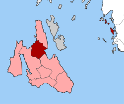
| Location in the municipality of Kefalonia and in the regional unit of Kefallinia | ||
Pylaros ( Greek Πύλαρος ( f. Sg. )) Is a municipality in the north of the island of Kefalonia . It was created in 1994 as a merger of the previously independent municipalities Makryotika, Divarata and Agia Effimia and merged with the administrative reform in 2010 in the newly created municipality of Kefalonia , in which it has since formed a municipality with 1391 inhabitants.
history
The first amalgamation of the municipalities took place in 1864, but it was dissolved by an official government decree in 1912. From then on there were the independent communities of Agia Effimia, Makryotika, Divarata, Ferentinata and Drakopoulata. In 1945 some residents from these communities founded the new villages Potamianata and Antypata. The earthquake of 1953 devastated the villages and a rural exodus began. In 1973 the villages were able to merge into three parishes in order to bring the parish of Pylaros back to life in 1994 (before the regional reform).
geography
Pylaros is located in the north of the island on two coasts and is very mountainous, the adjacent northern peninsula forms the municipality of Erisos with the local communities Asos and Fiskardo . To the west is the famous Myrtos beach , to the east is the small port of Agia Evfimia . Both are on the important road from Sami to Argostoli and Lixouri . The highest peaks are Agia Dynati (1131 m) in the south and Kalon Oros (900 m) in the north.
Economy and Infrastructure
The most important industries used to be the production of honey and sheep breeding. With the anarchist politician Marinos Antypas from Ferentinata, Pylaros became a center of the peasant movement. The inhospitable country led to a preoccupation with shipping as early as the 19th century. Only recently has the place itself achieved a certain level of prosperity through tourism, so the café on Myrtos Beach is run directly by the municipality.
The town hall and administration were in Agia Effimia, and the Citizens' Office (KEP) has recently been in existence as a contact for all official questions. Furthermore, in Agia Effimia there is a police station, a post office, a country doctor's practice, a branch of the Emporiki Bank and a pharmacy. Makryotika is home to the community's only school and preschool, as well as the Sissimatios city library and the KAPI senior center.
There is an association for the protection of the forest, a small hotelier association, a milk producers' cooperative and a sports club.
people
- Marinos Antypas (1872–1907), anarchist
- Themos Potamianos , writer
Individual evidence
- ↑ Results of the 2011 census at the National Statistical Service of Greece (ΕΛ.ΣΤΑΤ) ( Memento from June 27, 2015 in the Internet Archive ) (Excel document, 2.6 MB)


