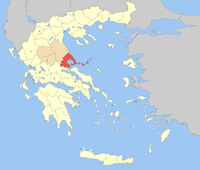
Magnisia (prefecture)
|
Magnisia Prefecture (1899–1909, 1942–2010) Νομός Μαγνησίας |
|
|---|---|

|
|
| Basic data (April 2010) | |
| State : | Greece |
| Administrative region : | Thessaly |
| Surface: | 2,636 km² |
| Residents: | 205.005 |
| Population density: | 77.77 inhabitants per km² |
| Capital: | Volos |
| Municipalities (δήμοι): | 22nd |
| Rural communities (κοινότητες): | 4th |
| ISO-3166-2 code : | GR-43 |
| NUTS 3 code : | EL613 |
| License plate : | BO ( Vo los) |
| Website : | www.magnesia.gr |
Magnisia ( Greek Μαγνησία ( f. Sg. ), Ancient Greek transcription Magnēsía ) was one of the four prefectures of the administrative region of Thessaly in Greece until 2010 . The name is derived from the name of a Macedonian tribe, the magnets . The prefecture was created in 1942 by Larisa Department . With the administrative reform of 2010 , the prefecture was abolished and divided into two regional districts ( Magnisia and Sporades , the latter includes the three island communities) of the Thessaly region, which, however, apart from the allocation of seats in the regional council, have no political significance.
geography
Magnisia, the easternmost independent landscape of Thessaly , with the mountains Ossa and Pelion , is a peninsula originally settled by Thracians , located north of Euboea on the Pagasitic Gulf.
Part of the Northern Sporades archipelago belonged to the Prefecture of Magnisia .
history
There was a Greek colony on the peninsula before. The city of the same name Magnesia on the Meander in Caria ( Ionia ), north of the Great Meander and on the eastern slope of the Thorax in Asia Minor , was founded by colonists from the Thessalian Magnesia. Another magnesia was located further north on Hermos in Lydia , which was probably also founded by the magnets .
The most important ancient city on the peninsula was Demetrias . Magnesia, like all of Thessaly, is said to have been ruled in earlier times by Pelasgians , who oppressed the peasants , the Penestas , like the Helots in Sparta . Then came the Thessalians , who, according to the old conception , should have been of Illyrian descent and immigrated from Epirus .
Municipalities 1997–2010
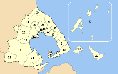
| List of urban (Dimos) and rural parishes (Kinotita) in Magnisia Prefecture | ||||||||||||
|---|---|---|---|---|---|---|---|---|---|---|---|---|
| No. | Parish name | YPES / LAU code | Administrative headquarters | postcode number |
Telephone area code |
2001 residents |
Area in km² |
Municipal districts |
Inhabitants per km² |
|||
| 08 | Afetes | Δήμος Αφετών | 3708/430800 | Neochori | Νεοχώρι | 370 10 | 24230- | 1,838 | 80.744 | 5 | 22.763 | |
| 02 | Agria | Δήμος Αγριάς | 3701/430200 | Agria | Αγριά | 373 00 | 24280- | 6.112 | 25.227 | 2 | 242,280 | |
| 03 | Esonia | Δήμος Αισωνίας | 3702/430300 | Dimini | Διμήνι | 385 00 | 24210 | 3,031 | 75.504 | 2 | 40.144 | |
| 04 | Almyros | Δήμος Αλμυρού | 3703/430400 | Almyros | Αλμυρός | 371 00 | 24220- | 12,987 | 473,940 | 8th | 27.402 | |
| 05 | Alonissus | Δήμος Αλοννήσου | 3704/430500 | Alonissos (Chora) | Αλόννησος (χώρα) | 370 05 | 24240- | 2,700 | 129,607 | 1 | 20,832 | |
| 06 | Argalasti | Δήμος Αργαλαστής | 3706/430600 | Argalasti | Αργαλαστή | 370 06 | 24230- | 2.158 | 74.820 | 3 | 28.843 | |
| 07 | Artemida | Δήμος Αρτέμιδας | 3707/430700 | Ano Lechonia | Άνω Λεχώνια | 385 00 | 24280- | 4,583 | 28.791 | 4th | 159.182 | |
| 22nd | Feres | Δήμος Φερών | 3726/432200 | Velestino | Βελεστίνο | 375 00 | 24250- | 6.116 | 215.513 | 5 | 28.379 | |
| 10 | Iolkos | Δήμος Ιωλκού | 3711/431000 | Iolkos | Ιωλκός | 385 00 | 24210- | 2,071 | 1.981 | 3 | 1,045,432 | |
| 11 | Karla | Δήμος Κάρλας | 3712 / | Stefanovikio | Στεφανοβίκειο | 375 00 | 24250- | 5,189 | 223,591 | 4th | 23.208 | |
| 12 | Milies | Δήμος Μηλεών | 3715/431200 | Milies | Μηλές | 370 10 | 24230- | 3,513 | 63.754 | 5 | 55.102 | |
| 13 | Mouresi | Δήμος Μουρεσίου | 3716/431300 | Tsangarada | Τσαγκαράδα | 370 12 | 24260- | 3,107 | 54.214 | 6th | 57.310 | |
| 14th | Nea Anchialus | Δήμος Νέας Αγχιάλου | 3717/431400 | Nea Anchialus | Νέα Αγχίαλος | 374 00 | 24280- | 7,411 | 80,462 | 3 | 92.106 | |
| 15th | Nea Ionia | Δήμος Νέας Ιωνίας | 3718/431500 | Nea Ionia | Νέα Ιωνία | 383 & 384 | 24210 | 31,929 | 63,314 | 2 | 504.296 | |
| 16 | Portaria | Δήμος Πορταριάς | 3719/431600 | Portaria | Πορταριά | 370 11 | 24280- | 3,201 | 22.754 | 4th | 140.679 | |
| 17th | Pteleus | Δήμος Πτελεού | 3720/431700 | Pteleus | Πτελεός | 370 07 | 24220- | 2,881 | 118.230 | 3 | 24.368 | |
| 18th | Sipiada | Δήμος Σηπιάδος | 3721/431800 | Lafkos | Λαύκος | 370 06 | 24230- | 2,358 | 122,404 | 3 | 19.264 | |
| 19th | Skiathos | Δήμος Σκιάθου | 3722/431900 | Skiathos | Σκίαθος | 370 03 | 24240- | 6.160 | 49.898 | 1 | 123.452 | |
| 20th | Skopelos | Δήμος Σκοπέλου | 3723/432000 | Skopelos | Σκόπελος | 370 03 | 24240- | 4,696 | 96.299 | 3 | 48.765 | |
| 21st | Sourpi | Δήμος Σούρπης | 3724/432100 | Sourpi | Σούρπη | 370 08 | 24220- | 4,314 | 191,355 | 6th | 22,547 | |
| 01 | Volos | Δήμος Βόλου | 3709/430100 | Volos | Βόλος | 380-382 | 24210 | 82,439 | 27.678 | 1 | 2,978.503 | |
| 09 | Zagora | Δήμος Ζαγοράς | 3710/430900 | Zagora | Ζαγορά | 370 01 | 24260- | 3,829 | 96.101 | 3 | 39.843 | |
| 23 | Anavra | Κοινότητα Ανάβρας | 3705/436100 | Anavra | Ανάβρα | 350 10 | 22320-9 | 987 | 121.859 | 1 | 8.100 | |
| 24 | Keramidi | Κοινότητα Κεραμιδίου | 3713/436200 | Keramidi | Κεραμίδι | 385 00 | 24280-7 | 782 | 111.532 | 1 | 7.011 | |
| 25th | Makrinitsa | Κοινότητα Μακρινίτσας | 3714/436300 | Makrinitsa | Μακρινίτσα | 370 11 | 24280-99 | 898 | 59.903 | 1 | 14,991 | |
| 26th | Trikeri | Κοινότητα Τρικερίου | 3725/436400 | Trikeri | Τρικέρι | 370 09 | 24230-91 | 1,696 | 26.817 | 1 | 63.243 | |
| Sum or average of the prefecture | 26 municipalities, including 22 urban and 4 rural municipalities (blue) | 206.995 | 2,636,272 | 81 | 78.518 | |||||||
|
All information is based on publicly available information from the Greek Ministry of the Interior (YPES). and the National Statistical Service of Greece (EYSE). The rural communities are highlighted in light blue. The capital of the prefecture is highlighted in orange. |
||||||||||||
Individual evidence
- ↑ The population figures come from a brochure of the Greek Ministry of the Interior from May 2010 on the occasion of the administrative reform under the 'Kallikratis Law': Elliniki Dimokratia, Ypourgeio Esoterikon, Apokendrosis ke Ilektronikis Diakyvernisis: "Programma Kallikratis", Systasi, syngrotisi Dimon, Periferion ke Apikokendromenon ti Nea Architektoniki tis Aftodiikisis ke tis Apokendromenis Diikisis, Athens 2010.
- ↑ a b c 2001 census, source: National Statistical Service of Greece (ΕΣΥΕ), ( PDF ( Memento of April 18, 2009 in the Internet Archive ) 875 kB)
- ↑ a b 2001 Census, National Statistics Agency of Greece (EYSE). ( Memento from September 29, 2007 in the Internet Archive )
- ↑ Local self-government. Greek Ministry of the Interior ( Memento from August 15, 2003 in the Internet Archive ) (ΥΠΟΥΡΓΕΙΟΥ ΕΣΩΤΕΡΙΚΩΝ, ΔΗΜΟΣΙΑΣ ΔΙΟΙΚΗΣΗΣ ΚΑΙ ΑΠΟΚΕΝΤΡΩΣΗΣ; ΥΠ.ΕΣ or YPES)
Coordinates: 39 ° 21 ' N , 22 ° 59' E
