
Agria (Greece)
|
Agria Municipality Δημοτική Ενότητα Αγριάς (Αγριά) |
|||
|---|---|---|---|
|
|||
| Basic data | |||
| State : |
|
||
| Region : |
Thessaly
|
||
| Regional District : | Magnesia | ||
| Municipality : | Volos | ||
| Geographic coordinates : | 39 ° 20 ′ N , 23 ° 1 ′ E | ||
| Height above d. M .: | 111 m (average) |
||
| Area : | 25.227 km² | ||
| Residents : | 5,632 (2011) | ||
| Population density : | 223.3 inhabitants / km² | ||
| Code No .: | 240102 | ||
| Structure: |
1 city district 1 local community |
||
| Located in the municipality of Volos and Magnisia regional unit | |||
 |
|||

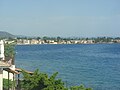
Agria ( Greek Αγριά ( f. Sg. )) Is a small Greek town with (2011) 5191 inhabitants in the region of Thessaly . Together with three neighboring villages Agria formed a municipality, but was incorporated into the city of Volos with the administrative reform in 2010 . Since then Agria has had the status of a municipality, the small town itself forms a municipality of the same name (Δημοτική Κοινότητα). Agria is located about 7 km east of Volos on the Pagasetic Gulf at the foot of the Pelion Mountains.
The city is famous for its olive and citrus fruit trade.
The lemonade EPSA (ΕΨΑ) has been made here since 1924.
Agria is the birthplace of the musician Vangelis .
photos
Agria

Agria

railway station

.JPG)

Web links
Commons : Agria - album with pictures, videos and audio files
Individual evidence
- ↑ Results of the 2011 census at the National Statistical Service of Greece (ΕΣΥΕ) ( Memento from June 27, 2015 in the Internet Archive ) (Excel document, 2.6 MB)