Dytiki Achaia
|
Municipality of Dytiki Achaia Δήμος Δυτικής Αχαΐας (Δυτική Αχαΐα) |
||
|---|---|---|
|
|
||
| Basic data | ||
| State : |
|
|
| Region : | West Greece | |
| Regional District : | Achaia | |
| Geographic coordinates : | 38 ° 8 ' N , 21 ° 27' E | |
| Area : | 573.3 km² | |
| Residents : | 25,916 (2011) | |
| Population density : | 45.2 inhabitants / km² | |
| Seat: | Kato Achaia | |
| LAU-1 code no .: | 3703 | |
| Districts : | 4 municipal districts | |
| Local self-government : |
2 city districts 38 local communities |
|
| Website: | dimosdymaion.gr | |
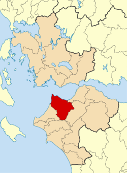
| Location in the region of Western Greece | ||
Dytiki Achaia ( Greek Δυτική Αχαΐα ) is a municipality in the Greek region of western Greece . The community area is 573.3 km². According to the 2011 census, the parish had 25,916 inhabitants. The administrative seat of the municipality is the small town of Kato Achaia .
location
The municipality is located in the northwest of the Peloponnese peninsula. It has an area of 573.3 km². Neighboring communities are in the east and south-east Patras and Erymanthos , in the south Ilida and in the south-west Andravida-Kyllini
The west coast is dominated by the lagoons and wetlands of the Kotychi-Strofylia Wetlands National Park .
Administrative division
The municipality was formed after the administrative reform in 2010 from the merger of the former municipalities Dymi , Larissos , Movri and Olenia . The administrative seat of the municipality is the small town of Kato Achaia. The former municipalities have since formed municipal districts. The community is further subdivided into 2 city districts and 38 local communities.
| Parish | Greek name | code | Area (km²) | Residents 2011 | City districts / local communities (Δημοτική / Τοπική Κοινότητα) |
location |
|---|---|---|---|---|---|---|
| Dymi | Δημοτική Ενότητα Δύμης | 370301 | 71,553 | 10,227 | Kato Achaia, Agiovlasitika, Alissos , Ano Achaia, Eleochori, Kato Alissos, Niforeika, Petrochori | |
| Larissus | Δημοτική Ενότητα Λαρίσσου | 370302 | 225.729 | 5,650 | Metochi, Agios Nikolaos Spaton, Apideonas, Araxos, Velitses, Kangadi, Lakkopetra, Mataranga, Michio, Peta, Riolos | |
| Movri | Δημοτική Ενότητα Μόβρης | 370303 | 86,484 | 4,605 | Kareika, Krinos, Limnochori, Myrtos, Sageika, Franga | |
| Olenia | Δημοτική Ενότητα Ωλενίας | 370304 | 189,534 | 5,434 | Agios Nikolaos Kralis, Agios Stefanos, Ano Soudeneika, Arla, Achaiko, Galaneika, Ganeika, Kato Mazareika, Lousika, Mitopoli, Portes, Sandomeri, Flokas, Fostena, Charavgi | |
| total | 3703 | 573,300 | 25,916 | |||
traffic
In the northwest of the municipality is the Araxos air force base , which is also used for charter traffic in the summer months. National road 9 , which connects Patras with Pyrgos , runs through the municipality .
Individual evidence
- ↑ Results of the 2011 census at the National Statistical Service of Greece (ΕΛ.ΣΤΑΤ) (Excel document, 2.6 MB)
- ↑ Kotychi-Strofylia Wetlands National Park
- ↑ Law 3852/2010, «Νέα Αρχιτεκτονική της Αυτοδιοίκησης και της Αποκεντρωμένης Διοίκησης - Πρόγραμμα Καλης. ΦΕΚ 87 A / 7.6.2010, Άρθρο 1. Σύσταση δήμων. P. 1787. PDF Online (Greek)


