
Ilida
|
Municipality of Ilida Δήμος Ήλιδας (Ήλιδα) |
|||
|---|---|---|---|
|
|||
| Basic data | |||
| State : |
|
||
| Region : | West Greece | ||
| Regional District : | Elis | ||
| Geographic coordinates : | 37 ° 51 ′ N , 21 ° 27 ′ E | ||
| Area : | 401.9 km² | ||
| Residents : | 32,219 (2011) | ||
| Population density : | 80.2 inhabitants / km² | ||
| Seat: | Amaliada | ||
| LAU-1 code no .: | 3902 | ||
| Districts : | 2 parishes | ||
| Local self-government : |
1 city district 35 local communities |
||
| Website: | www.dimosilidas.gr | ||
| Location in the region of Western Greece | |||
 |
|||

Ilida ( pronunciation : [ ˈiliða ], Greek Ήλιδα ( f. Sg. )) Is a municipality in the west of the Greek Peloponnese peninsula around the city of Amaliada . It was formed on January 1, 2011 from the communities Amaliada and Pinia and named after the ancient Polis Elis , the remains of which are in the municipality. 16,763 inhabitants live in Amaliada, just as many in the rest of the municipality.
As early as 1833–1912 there was a community of Ilida, albeit around the town of Gastouni , in which the neighboring community of Elissa was incorporated in 1841, whose center, the settlements of Dervi-Tselebi and Kalista, were renamed Amaliada in 1885. Elissa existed again from 1906 to 1912, after which numerous small rural communities were created. In 1915 the rural community of Paleopoli was renamed Ilida. This was incorporated into Amaliada in 1997 with 18 other rural communities. The situation is similar with the municipality of Pinia, which was preceded by a municipality Dimos Piniion Δήμος Πηνειΐων, which existed from 1835–1912 and was created again in 1997 as Pinia around the administrative seat of Simopoulo from 15 rural communities. With the union of Pinias and Amaliadas to Ilida in the course of the administrative reform in 2010 , Amaliada became the municipality seat .
The municipality extends in a west-east direction south of the Pinios river and its reservoir. The western part with Amaliada lies in the plain of Elis. A 16-kilometer stretch of coast on the Ionian Sea is lined with sandy beaches, and the 85-hectare forest of Marathia extends over the sand dunes behind. To the east, the mountainous terrain on the upper reaches of the Pinios rises to around 500 m to the southern end of the Erymanthos mountain range . The eastern border to Lasiona is marked by the oak forest of Kapeli , which is designated as a Natura 2000 area .
Neighboring communities are (starting northwest, clockwise) Pinios , Andravida-Kyllini , Dytiki Achaia , Erymanthos , Archea Olymbia and Pyrgos .

The Pinios reservoir

The Byzantine monastery of Frangavilla in Amaliada
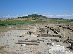
Archaeological site of ancient Elis
.JPG)
1.JPG)

Community structure
The 36 municipalities that existed until 1997 have had the status of an urban district (Ez. Gr. Dimotiki kinotita ) - namely Amaliada - or of local communities (topiki kinotita) since 2011 and elect a council or an individual representative as local representative, depending on the number of inhabitants. The population figures come from the results of the 2011 census.
- Amaliada Parish - Δημοτική Ενότητα Αμαλιάδος - 28,520
- Amaliada District - Δημοτική Κοινότητα Αμαλιάδος - 18.303
- Agios Ioannis - Άγιος Ιωάννης - 431
- Amaliada - Αμαλιάδα - 16,763
- Kouroutas - Κουρούτας - 433
- Marathia - Μαραθιά - 260
- Palouki - Παλούκι - 143
- Panagia - Παναγία - 122
- Tsafleika - Τσαφλέικα - 91
- Tsichleika - Τσιχλέικα - 60
- Local community Agios Dimitrios - Τοπική Κοινότητα Αγίου Δημητρίου - 382
- Agios Dimitrios - Άγιος Δημήτριος - 261
- Kolokythas - Κολοκυθάς - 121
- Local community Agios Ilias - Τοπική Κοινότητα Αγίου Ηλία Πηνηίων - Άγιος Ηλίας - 302
- Local community Ambelokambos - Τοπική Κοινότητα Αμπελοκάμπου - Αμπελόκαμπος - 468
- Local community Archea Ilida - Τοπική Κοινότητα Αρχαίας Ήλιδας - Αρχαία Ήλιδα - 306
- Local community Avgio - Τοπική Κοινότητα Αυγείου - Αυγείο - 325
- Local community Geraki - Τοπική Κοινότητα Γερακίου - 614
- Analipsi - Ανάληψη - 113
- Geraki - Γεράκι - 501
- Local community Dafni - Τοπική Κοινότητα Δάφνης - 543
- Dafni - Δάφνη - 515
- Karathas - Καλαθάς - 28
- Local community Dafniotissa - Τοπική Κοινότητα Δαφνιωτίσσης - Δαφνιώτισσα - 366
- Local community Douneika - Τοπική Κοινότητα Δουναίικων - 677
- Agia Marina - Αγία Μαρίνα - 18
- Danika - Δανικά - 16
- Douneika - Δουναίικα - 616
- Kato Kertezeika - Κάτω Κερτεζαίικα - 27
- Local community Kalyvia - Τοπική Κοινότητα Καλυβίων Ήλιδος - Καλύβια - 435
- Local community Kardamas - Τοπική Κοινότητα Καρδαμά - 977
- Kardamas - Καρδαμάς - 948
- Petroules - Πετρούλες - 29
- Local community Kendro - Τοπική Κοινότητα Κέντρου - Κέντρο - 462
- Local community Keramidia - Τοπική Κοινότητα Κεραμιδιάς - Κεραμιδιά - 526
- Local community Kryonero– Τοπική Κοινότητα Κρυονέρου - Κρυόνερο - 300
- Local community Peristeri - Τοπική Κοινότητα Περιστερίου - 363
- Asterica - Αστεραίικα - 43
- Paleolanthi - Παλαιολάνθη - 11
- Peristeri - Περιστέρι - 309
- Local community Roviata - Τοπική Κοινότητα Ροβιάτας - 345
- Kasidiaris - Κασιδιάρης - 17
- Paralia - Παραλία - 30
- Roviata - Ροβιάτα - 281
- Romeika - Ρωμέικα - 17th
- Local community Savalia - Τοπική Κοινότητα Σαβαλίων - Σαβάλια - 1.206
- Local community Sosti - Τοπική Κοινότητα Σωστίου - Σώστι - 308
- Local community Chavari - Τοπική Κοινότητα Χαβαρίου - 1.312
- Agios Georgios - Άγιος Γεώργιος - 76
- Pera Chavari - Πέρα Χαβάρι - 53
- Chavari - Χαβάρι - 1,183
- Amaliada District - Δημοτική Κοινότητα Αμαλιάδος - 18.303
- Municipality of Pinia - Δημοτική Ενότητα Πηνελιας - 3,699
- Local community Agnanda - Τοπική Κοινότητα Αγνάντων - 242
- Agnanda - Άγναντα - 210
- Ambelakia - Αμπελάκια - 32
- Local community Agrapidochori - Τοπική Κοινότητα Αγραπιδοχωρίου - 147
- Agrapidochori - Αγραπιδοχώρι - 42
- Valmi - Βάλμη - 88
- Kotrona - Κοτρώνα - 17th
- Local community Anthonas - Τοπική Κοινότητα Ανθώνος - 161
- Anthonas - Ανθώνας - 95
- Kalo Pedi - Καλό Παιδί - 66
- Local community Avgi - Τοπική Κοινότητα Αυγής - 209
- Avgi - Αυγή - 59
- Orea - Ωραία - 150
- Local community Velanidi - Τοπική Κοινότητα Βελανιδίου - 226
- Velanidi - Βελανίδι - 172
- Roupakia - Ρουπακιά - 32
- Souli - Σούλι - 22
- Local community Vouliagmeni - Τοπική Κοινότητα Βουλιαγμένης - 327
- Vouliagmeni - Βουλιαγμένη - 303
- Gavrakia - Γαβράκια - 24
- Local community Efyra - Τοπική Κοινότητα Εφύρας - 268
- Efyra - Εφύρα - 266
- Piri - Πιρί - 2
- Local community Kambos - Τοπική Κοινότητα Κάμπου - Κάμπος - 111
- Local community Laganas - Τοπική Κοινότητα Λαγανά - Λαγανάς - 181
- Local community Latas - Τοπική Κοινότητα Λάτα - Λάτας - 204
- Local community Loukas - Τοπική Κοινότητα Λουκά - 155
- Loukas - Λουκάς - 91
- Prinari - Πρινάρι - 64
- Local community Mazaraki - Τοπική Κοινότητα Μαζαρακίου - 407
- Apidoula - Απιδούλα - 45
- Mazaraki - Μαζαράκι - 188
- Prodromos - Πρόδρομος - 174
- Local community Inoi - Τοπική Κοινότητα Οινόης - Οινόη - 298
- Local community Rodia - Τοπική Κοινότητα Ροδιάς - 253
- Akrotamia - Ακροποταμιά - 75
- Rodia - Ροδιά - 178
- Local community Simopoulo - Τοπική Κοινότητα Σιμοπούλου - 390
- Agios Nikolaos - Άγιος Νικόλαος - 21
- Simopoulo - Σιμόπουλο - 369
- Local community Skliva - Τοπική Κοινότητα Σκλίβας - Σκλίβα - 120
- Local community Agnanda - Τοπική Κοινότητα Αγνάντων - 242
Individual evidence
- ↑ a b Results of the 2011 census at the National Statistical Service of Greece (ΕΛ.ΣΤΑΤ) ( Memento from June 27, 2015 in the Internet Archive ) (Excel document, 2.6 MB)
- ↑ Administrative history of the database of the EETAA (Greek Society for Development and Decentralization) ( Memento of the original from October 16, 2013 in the Internet Archive ) Info: The archive link was inserted automatically and has not yet been checked. Please check the original and archive link according to the instructions and then remove this notice.