Aktio-Vonitsa
|
Municipality of Aktio-Vonitsa Δήμος Ακτίου-Βόνιτσας (Άκτιο-Βόνιτσα) |
||
|---|---|---|
|
|
||
| Basic data | ||
| State : |
|
|
| Region : | West Greece | |
| Regional District : | Aetolia-Acarnania | |
| Geographic coordinates : | 38 ° 55 ' N , 20 ° 53' E | |
| Area : | 660.172 km² | |
| Residents : | 17,370 (2011) | |
| Population density : | 26.3 inhabitants / km² | |
| Seat: | Vonitsa | |
| LAU-1 code no .: | 3802 | |
| Districts : | 3 municipal districts | |
| Local self-government : |
3 city districts 14 local communities |
|
| Website: | www.aktiovonitsa.gov.gr | |
| Location in the region of Western Greece | ||
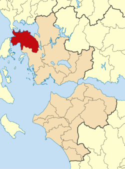
Aktio-Vonitsa ( Greek Άκτιο-Βόνιτσα ) is a municipality in the Greek region of western Greece . The administrative seat of the municipality is the city of Vonitsa. The area of the municipality is 660.172 km².
location
The municipality of Aktio-Vonitsa is located in the north-west of the region of Western Greece. The Ionian Sea in the west forms the natural border with the neighboring municipality of Lefkada in the Ionian Islands region . Beyond the Ambracian Gulf in the north are the municipalities of Arta and Preveza in the Epirus region , the latter is connected to Aktio-Vonitsa via the Preveza-Aktio tunnel . Amfilochia is in the east and Xiromero in the south. The Arkananiká mountain range is located in the southeast of the municipality.
Community structure
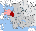
The municipality was formed in the course of the administrative reform in 2010 from the merger of the former municipalities Anaktorio , Paleros and Medeon , these correspond to today's municipal districts. The administrative center is the small town of Vonitsa. This
| Parish | Greek name | code | Area (km²) | Residents 2011 | City districts / local communities (Δημοτική / Τοπική Κοινότητα) |
location |
|---|---|---|---|---|---|---|
| Anaktorio | Δημοτική Ενότητα Ανακτορίου | 380201 | 241,112 | 9,129 | Vonitsa, Agios Nikolaos, Drymos, Thyrio, Monastiraki, Paliambela | |
| Medeon | Δημοτική Ενότητα Μεδεώνος | 380202 | 213.217 | 3,858 | Katouna, Aetos, Achyra, Komboti, Konopina, Tryfos | |
| Paleros | Δημοτική Ενότητα Παλαίρου | 380203 | 205.843 | 4,383 | Paleros, Vatos, Peratia, Plagia, Pogonia | |
| total | 3802 | 660.172 | 17,370 | |||
traffic
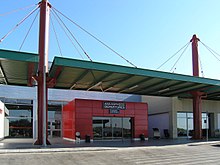
In the north-west of the municipality is the Aktio airport , which emerged from a NATO air force base and is mainly served by charter traffic.
The national road 42 runs in the north of the municipality near the Ambracian Gulf. It creates a connection between Lefkada and the A5 near Amfilochia.
history
At Aktio took place in the year 31 BC. The naval battle of Actium between the fleet of Octavian (later emperor Augustus) on one side and the fleets of Mark Antony and Cleopatra on the other.
More detailed description of history and sights in the main article Anaktorio .
Individual evidence
- ↑ Results of the 2011 census at the National Statistical Service of Greece (ΕΛ.ΣΤΑΤ) ( Memento from June 27, 2015 in the Internet Archive ) (Excel document, 2.6 MB)
- ↑ Law 3852/2010, «Νέα Αρχιτεκτονική της Αυτοδιοίκησης και της Αποκεντρωμένης Διοίκησης - Πρόγραμμα Καλης. ΦΕΚ 87 A / 7.6.2010, Άρθρο 1. Σύσταση δήμων. P. 1785. PDF Online (Greek)


