Amfilochia
|
Amfilochia municipality Δήμος Αμφιλοχίας (Αμφιλοχία) |
||
|---|---|---|
|
|
||
| Basic data | ||
| State : |
|
|
| Region : | West Greece | |
| Regional District : | Aetolia-Acarnania | |
| Geographic coordinates : | 38 ° 52 ′ N , 21 ° 11 ′ E | |
| Area : | 1,091.81 km² | |
| Residents : | 17,056 (2011) | |
| Population density : | 15.6 inhabitants / km² | |
| Seat: | Amfilochia | |
| LAU-1 code no .: | 3804 | |
| Districts : | 3 municipal districts | |
| Local self-government : |
1 city district 26 local communities |
|
| Website: | www.amfiloxia.gov.gr | |
| Location in the region of Western Greece | ||
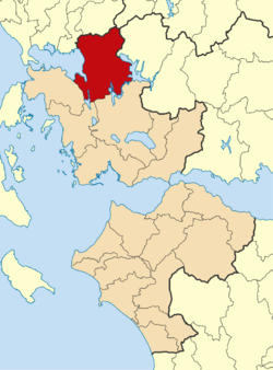
Amfilochia ( pronunciation : [ aɱfilɔˈçia ], Greek Αμφιλοχία ( f. Sg. ); Alternative transliteration Amphilochia ) is a small town and a municipality in the north of the Greek region of western Greece . Amfilochia is located on a southern branch of the Ambracian Gulf and is modeled on an amphitheater built into the coastal slopes. In the west as in the east of the small town, hills and mountain ranges rise; only to the south does a narrow valley extend between the aforementioned elevations.
The area around Amfilochia has been populated since ancient times; the ancient settlement Limnaia (Limnea) was there. Remains of the ancient walls of Limnaia are still visible today in the eastern part of Amfilochia. During the Ottoman occupation, the small town was called Karvasaras. In 1907 the name was changed to Amfilochia.
Since the incorporation of the neighboring communities Menidi and Inachos in 2011, the community Amfilochia has encompassed the north of the Aetolian landscape and stretches across the Makrinoros hill chain and the valley of the Inachos river to the Valtos mountains to the east, where the summit of the Pyramida at 1782 m ü. d. M. forms the highest point of the municipality. This means that the municipality almost covers that of the former province of Valtos, which was dissolved in 1997.
Amfilochia is passed from the national road 5 ( European route 55 or European route 951 ) coming from the northeast ( Ioannina , Arta ) leading south ( Agrinio , Mesolongi ). The Highway 5 will also happen Amfilochia. The national road 42 branches off the national road 5 in Amfilochia and leads via Vonitsa to the island of Lefkada along the south coast of the Ambracian Gulf. There is no railway connection.
Community structure
The three municipalities merged in 2011 now form municipal districts, which comprise one city district and 26 local communities.
- Amfilochia parish - Δημοτική Ενότητα Αμφιλοχίας - 10,264
- Amfilochia district - Δημοτική Κοινότητα Αμφιλοχίας - Αμφιλοχία - 4,325 inhabitants
- Local community Ambelakio - Τοπική Κοινότητα Αμπελακίου - Αμπελακίο - 681 inhabitants
- Local community Anixiatiko - Τοπική Κοινότητα Ανοιξιάτικου - Ανοιξιάτικο - 894 inhabitants
- Local community Kechrinia - Τοπική Κοινότητα Κεχρινιάς - Κεχρινιά - 762 inhabitants
- Local community Loutro - Τοπική Κοινότητα Λουτρού - Λουτρό - 1,077 inhabitants
- Local community Megas Kambos - Τοπική Κοινότητα Μέγα Κάμπο - Μέγας Κάμπος - 62 inhabitants
- Local community Sardinio - Τοπική Κοινότητα Σαρδινίων - Σαρδίνια - 625 inhabitants
- Local community Sparto - Τοπική Κοινότητα Σπάρτου - Σπάρτο - 561 inhabitants
- Local community Stanos - Τοπική Κοινότητα Στάνου - Στάνος - 935 inhabitants
- Local community Varetada - Τοπική Κοινότητα Βαρετάδας - Βαρετάδα - 342 inhabitants
- Municipality of Inachos - Δημοτική Ενότητα Ινάχου - 4,760 inhabitants
- Local community Agridio - Τοπική Κοινότητα Αγριδίου - Αγρίδιο - 171 inhabitants
- Local community Alevrada - Τοπική Κοινότητα Αλευράδας - Αλευράδα - 124 inhabitants
- Local community Amorgiani - Τοπική Κοινότητα Αμοργιανών - Αμοργιανοί - 426 inhabitants
- Local community Babalio - Τοπική Κοινότητα Μπαμπαλιού - Μπαμπαλιόν - 66 inhabitants
- Local community Chalkiopouli - Τοπική Κοινότητα Χαλκιοπούλων - Χαλκιόπουλοι - 827 inhabitants
- Local community Giannopouli - Τοπική Κοινότητα Γιαννοπούλων - Γιαννόπουλοι - 194 inhabitants
- Local community Embresos - Τοπική Κοινότητα Εμπεσού - Εμπεσός - 531 inhabitants
- Local community Malesiada - Τοπική Κοινότητα Μαλεσιάδας - Μαλεσιάδα - 370 inhabitants
- Local community Patiopoulo - Τοπική Κοινότητα Πατιοπούλου - Πατιόπουλο - 581 inhabitants
- Local community Perdikaki - Τοπική Κοινότητα Περδικακίου - Περδικάκι - 403 inhabitants
- Local community Petrona - Τοπική Κοινότητα Πετρώνας - Πετρώνα - 152 inhabitants
- Local community Podogora - Τοπική Κοινότητα Ποδογοράς - Ποδογορά - 130 inhabitants
- Local community Stathas - Τοπική Κοινότητα Σταθά - Σταθάς - 322 inhabitants
- Local community Triklino - Τοπική Κοινότητα Τρικλίνου - Τρίκλινο - 145 inhabitants
- Local community Vrouviana - Τοπική Κοινότητα Βρουβιανών - Βρουβιανά - 318 inhabitants
- Menidi municipality - Δημοτική Ενότητα Μενιδίου - 2,032 inhabitants
- Local community Floriada - Τοπική Κοινότητα Φλωριάδος - Φλωριάδα - 699 inhabitants
- Local community Menidi - Τοπική Κοινότητα Μενιδίου - Μενίδι - 1,333 inhabitants
Individual evidence
- ↑ Results of the 2011 census at the National Statistical Service of Greece (ΕΛ.ΣΤΑΤ) ( Memento from June 27, 2015 in the Internet Archive ) (Excel document, 2.6 MB)


