
Supramonte
| Supramonte | ||
|---|---|---|
 View from Supramonte di Oliena in east direction (Dorgali) |
||
| Highest peak | Monte Corrasi ( 1463 m slm ) | |
| location | Sardinia, Italy | |
|
||
| Coordinates | 40 ° 15 ′ N , 9 ° 26 ′ E | |

The Supramonte is located in the Barbagia and is the second highest mountain range in Sardinia after the Gennargentu .
The Supramonte extends on the central east coast of Sardinia in a sweeping plateau of Mesozoic limestone in the area of the municipalities of Oliena , Orgosolo , Dorgali and Urzulei . The average peak height is 900 m, while the highest point, Monte Corrasi , reaches 1463 m. In the saddle of the neighboring 1349 m high Punta sos Nidos , the "Cooperativa Enis Monte Maccione" operates a hostel and a campsite in the largest holm oak forest on the island. The landscape is heavily dissected, often interrupted by narrow gorges, imposing limestone peaks, vast plateaus, deep sinkholes and hidden ravines . There is no surface water at all due to the rugged limestone that swallows any precipitation and directs it into large underground lakes. Parts of it reappear in the karst spring Su Gologone . The most significant natural attraction of the mountain region is the Gola Gorroppu gorge carved out by the Riu Flumineddu river , a gorge that is considered one of the largest in Europe.
The periodically changing murals by Orgosolo form a cultural highlight in the mountain region - as graffiti-like, Sardinian-style facade images, they reflect, in different art styles, especially the political and social situation on the island.

Pass Genna Silana, view towards Dorgali
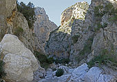
Gola su Gorropu canyon


literature
- Eberhard Fohrer: Sardinia. Michael Müller Verlag, Erlangen 2013
- Peter Höh: Sardinien , 4th edition 2006, Reise Know-How Verlag, Bielefeld, ISBN 3-8317-1464-9