
Strait of Bonifacio
| Strait of Bonifacio | |
|---|---|
 |
|
| Connects waters | Tyrrhenian Sea |
| with water | Mediterranean Sea |
| Separates land mass | Corsica |
| of land mass | Sardinia |
| Data | |
| Geographical location | 41 ° 19 ′ N , 9 ° 13 ′ E |
 |
|
| Smallest width | 12 km |
| Greatest depth | 70 m |
| Coastal towns | Bonifacio , Santa Teresa Gallura |
| Islands | Îles Lavezzi |
The Strait of Bonifacio ( Latin Gallicum or Taphros Fretum , Italian Bocche di Bonifacio , French Bouches de Bonifacio ) is the strait between Corsica and Sardinia , named after the Corsican coastal town of Bonifacio . The passage, about twelve kilometers wide and up to 70 meters deep, is feared by seafarers because of its adverse weather conditions , ocean currents , shallows , rocks, reefs and other obstacles.
The best-known shipwreck in the Strait of Bonifacio was the sinking of the French frigate Sémillante on February 15, 1855. The ship ran into a reef during storms and heavy seas and sank with 693 people on board, including around 400 soldiers. Nobody survived the disaster. There is a memorial in the Lavezzi cliffs to commemorate this disaster .
The fauna is exceptionally rich, around 1,745 animal species live here (as of 2011). The high limestone cliffs below Bonifacio are a rare and impressive sight. Since 2002 the Strait of Bonifacio has been on France's list of proposals for UNESCO World Heritage . The Straits of Bonifacio is also part of the European Straits Initiative (ESI ), which was launched in 2009 and comprises eight European straits from the Baltic to the Mediterranean.
environmental Protection
After a tanker accident in 1993, the passage between the two islands was blocked for French and Italian ships with dangerous cargo .
In June 2010 the Italian Environment Minister Stefania Prestigiacomo and her French colleague Jean-Louis Borloo signed the declaration of intent in Sardinia for a transboundary marine reserve in the strait between Corsica and Sardinia.
After the London International Maritime Organization (IMO) had examined and confirmed that the area was particularly worthy of protection, the French Environment Minister Nathalie Kosciusko-Morizet declared the road from Bonifacio to the "Zone Maritime Particulièrement Vulnérable (ZMPV)" ( English : "Particularly Sensitive Sea Area (PSSA) ”), that is, to the particularly endangered sea area. This legal status allows the coastal states of France and Italy to implement protective measures such as pilotage and the control of dangerous goods traffic, which includes ships from all third countries.
Picture gallery

Aerial view of the Strait of Bonifacio
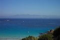
View from Sardinia to Corsica
The Strait of Bonifacio from Capo Testa in Santa Teresa Gallura in Sardinia.
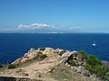
View from Capo Pertusato (Corsica). In the middle Îles Lavezzi , on the horizon Sardinia can be seen.
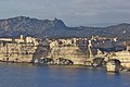
Bonifacio on the limestone cliff

Departure point of the ferry from Bonifacio to Sardinia (2003)


Movie
- Dream islands in the Mediterranean. Natural park between Corsica and Sardinia. Documentary, Germany, 2003, 42:50 min., Script and director: Andrea Maggi, production: Aldabra Productions, NDR Naturfilm, synopsis by ARD .
Web links
- Strait of Bonifacio: Strait of great ecological importance. In: ESA , May 6, 2011
- European Straits Initiative (ESI )
Individual evidence
- ↑ Ship accidents. Second half of the 19th century. ( Memento from April 26, 2009 in the Internet Archive ) In: Krisen-TV .
- ↑ a b Les Bouches de Bonifacio placées sous haute protection. In: Ministère de l'Écologie, du Développement durable et de l'Énergie , August 26, 2011.
- ↑ Image: Limestone cliffs near Bonifacio ( memento from October 19, 2014 in the Internet Archive ) in: esys.org .
- ↑ Bouches de Bonifacio. UNESCO World Heritage Center, February 1, 2002, accessed January 15, 2018 (French).
- ↑ On / at: Strait between Corsica and Sardinia: declaration of intent for an international marine protection area. In: nachrichten.sardinien.com , June 16, 2010.