
Capo Pertusato
Capo Pertusato is the name of the southern tip of Corsica .
The lighthouse of the same name takes its name from this well-known rock cliff of the same name, which rises here about 100 m above the water.
5 km south-east of Bonifacio , at the end of a narrow, steeply sloping road, it first curves past the Sémaphore (signal tower) and a military area. Remnants of buildings can also be seen here from the short period of occupation during the Second World War from 1941 to 1943 by the Italians and then the German army on their retreat from Sicily and Sardinia. But in September 1943 Corsica was the first French province to be free again. You meander through the maquis and finally reach the lighthouse of Pertusato . This lighthouse stands on 99 m high rock, its lamp is 116 m above sea level. It entered service in 1844. Its 1,000 watt halogen lamp can be seen 25 nautical miles, or approx. 46 km .
From here you can only continue on foot. Here you can see the islands of the Îles Lavezzi and Cavallo in the east, in the south the coast of Sardinia on the horizon and in the foreground the lighthouse of the Italian archipelago of La Maddalena with the US Navy base. Not far from the lighthouse is the footpath to the beach, Cala Fiumare . Above, various hikes are possible over the chalk cliffs of Capo Pertusato, for example to the Pointe de Sperone with its golf course, which is said to be the most beautiful in France. It consists of an 18-hole course with a length of approx. 6,100 m, a 72 handicap and a golf house that is well worth seeing. A little further east it goes to the Plage de Piantarella . Opposite this beautiful sandy bay are the islets of Piana and Ratino , which are part of the Lavezzi nature reserve. To the north of this is the clear, 400 m long coarse sand beach of Plage de Cala Longa .
The southernmost place of Corsica is known through the Strait of Bonifacio (Bouche de Bonifacio), the 12 km wide strait between Corsica and Sardinia , which attracts many sailors and also became the undoing of many sailors.

Capo Pertusato seen from the sea
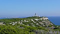
Capo Pertusato lighthouse, Sardinia can be seen in the background

The cape seen from the Bonifacios Citadel


Coordinates: 41 ° 22 ′ 4 " N , 9 ° 11 ′ 4" E