
Radicofani
| Radicofani | ||
|---|---|---|

|
|
|
| Country | Italy | |
| region | Tuscany | |
| province | Siena (SI) | |
| Coordinates | 42 ° 54 ' N , 11 ° 46' E | |
| height | 780 m slm | |
| surface | 118 km² | |
| Residents | 1,073 (Dec. 31, 2019) | |
| Population density | 9 inhabitants / km² | |
| Post Code | 53040 | |
| prefix | 0578 | |
| ISTAT number | 052024 | |
| Popular name | Radicofanesi | |
| Patron saint | Agatha of Catania (February 5th) | |
| Website | Radicofani municipality | |
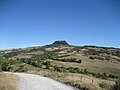
 Panorama of Radicofani |
||

Radicofani is an Italian municipality in Tuscany . The city is located in the province of Siena and has 1,148 inhabitants (as of May 31, 2013).
geography
.svg)
The municipality is located on the historic Via Francigena in Val d'Orcia , approx. 110 km southeast of the regional capital Florence and approx. 60 km southeast of the provincial capital, Siena . The village has a medieval town center and extends over a total area of over 118 km² , the population density is thus around 10 inhabitants / km². The place is in the climatic classification of Italian municipalities in zone E, 2 648 GG and on the rivers Formone (7 km in the municipality), Orcia (11 km in the municipality) and Paglia (3 km in the municipality).
Contignano is one of its districts (479 m, approx. 280 inhabitants).
The neighboring municipalities are Abbadia San Salvatore , Castiglione d'Orcia , Pienza , San Casciano dei Bagni and Sarteano .
history
Mentioned for the first time in AD 973 , today's small town nestles against the free-standing 896 meter high mountain "Rocca di Radicofani". In a strategically important key position, near the Via Cassia leading to Rome, between the fortresses Citonia and the Monte Amiata mountain , the fortress was initially owned by a nearby Benedictine abbey .
The city gained its original meaning from the incessant flow of pilgrims traveling through northern Italy on their way to the Holy City. Several attempts by secular rulers to expel the local monks, first in 1081 by the Aldobrandeschi and later in 1139 by Siena, failed and were followed by an edict by Pope Eugene III. subsequently prevented. Under two of the following popes, namely Hadrian IV and Innocent III. , the fortifications were strengthened and expanded from the ground up, so that Radicofani became a militarily relevant base in the ongoing dispute between the duchies of Siena and Orvieto. The eventful history of the following centuries was characterized by constant destruction and ambitious reconstruction as a result of the most varied of coalitions and alliances. The Salimbeni family from Senese, but Guelf, played a particularly important role when they declared the fortress as a family seat in 1262. Ghino di Tacco took over the castle in 1295, and in 1405 Siena finally took over the rule for which it had fought since 1352.
The provisional end of the fortress, which was last built by Siena in 1417, was sealed in April 1555 during the siege and extensive destruction by the Florentine imperial troops of Cosimo I de 'Medici . A few days later, Siena itself was captured by the same troops.
The castle complex, which was restored from 1929 in a multi-stage restoration and reconstruction, has been open to tourists since 1999.
Attractions
- the fortress ruins on the summit of the mountain, converted into a museum ( Parco Museo Città Fortificata di Radicofani )
- Pieve San Pietro , first mentioned in writing in 1224, contains works ( Annunciata and Madonne col Bambino e santi ) from the workshop of Andrea della Robbia and works by Benedetto Buglioni ( Crocifissione con la Maddalena , attributed) and Francesco di Valdambrino ( Madonna col Bambino , wooden statue)
- the 18th century church of Sant'Agata . Contains the work Madonna col Bambino ei Santi Francesco, Elisabetta d'Ungheria, Cristina di Bolsena e Lorenzo by Andrea della Robbia, created around 1500
- the 1293 built church of Santa Maria Assunta a Contignano in the district Contignano

Radicofani from afar

Pieve di San Pietro

Main tower (mastio) of the castle (Rocca)

Entrance and main tower of the castle


Personalities
- Ghino di Tacco , a notorious regional robber of the 13th century who temporarily used the fortress as a shelter
Awards
- The place is sponsor of the Bandiera Arancione of the TCI .
literature
- D'Atti, Monica & Cinti, Franco: Guida alla Via Francigena . Terre di Mezzo Editore, Milan 2007. ISBN 88-89385-65-0
- D'Atti, Monica & Cinti, Franco: La Via Francigena. Cartografia e GPS. Dal Monginevro a Roma lungo l'itinerario storico . Terre di Mezzo Editore, Milan 2007. ISBN 88-89385-60-X
- Emanuele Repetti: RADICOFANI from the Val d'Orcia e la Val di Paglia. In Dizionario Geografico Fisico Storico della Toscana (1833–1846), online edition of the University of Siena (PDF, ital.)
Web links
- Official website of the Municipality of Radicofani
- Website of the Pro Loco in Radicofani (Italian)
- Radicofani on the Castles and Fortresses website (Italian)
- Radicofani on the Fortresses of Tuscany website (English and Italian)
Individual evidence
- ↑ Statistiche demografiche ISTAT. Monthly population statistics of the Istituto Nazionale di Statistica , as of December 31 of 2019.
- ↑ ISTAT - National Institute for Statistics, Geographical Demography, monthly. Population balance, last updated May 31, 2013
- ↑ Website of the Agenzia nazionale per le nuove tecnologie, l'energia e lo sviluppo economico sostenibile (ENEA), accessed on June 15, 2014 (Italian) (PDF; 330 kB)
- ↑ Official website of the Sistema Informativo Ambientale della Regione Toscana (SIRA) on the rivers in Radicofani , accessed on June 15, 2014 (Italian)
- ↑ Official website of ISTAT ( Istituto Nazionale di Statistica ) on 2001 population figures in the province of Siena, accessed on June 15, 2014 (Italian)
- ^ Official website of the TCI on the Bandiera Arancione and Radicofani , accessed on June 1, 2015 (Italian)

Abbadia San Salvatore | Asciano | Buonconvento | Casole d'Elsa | Castellina in Chianti | Castelnuovo Berardenga | Castiglione d'Orcia | Cetona | Chianciano Terme | Chiusdino | Chiusi | Colle di Val d'Elsa | Gaiole in Chianti | Montalcino | Montepulciano | Monteriggioni | Monteroni d'Arbia | Monticiano | Murlo | Piancastagnaio | Pienza | Poggibonsi | Radda in Chianti | Radicofani | Radicondoli | Rapolano Terme | San Casciano dei Bagni | San Gimignano | San Quirico d'Orcia | Sarteano | Siena | Sinalunga | Sovicille | Torrita di Siena | Trequanda
← Previous location: Bagno Vignoni 27.4 km | Radicofani | Next town: Acquapendente 24.5 km →
![]() Canterbury |
Dover |
Calais |
Wissant |
Guînes |
Licques |
Wisques |
Thérouanne |
Auchy-au-Bois |
Bruay-la-Buissière |
Arras |
Bapaume |
Peronne |
Doingt |
Seraucourt-le-Grand |
Tergnier |
Laon |
Bouconville-Vauclair |
Corbeny |
Hermonville |
Reims |
Trépail |
Châlons-en-Champagne |
Cool |
Brienne-le-Château |
Bar-sur-Aube |
Châteauvillain |
Blessonville |
Langres |
Humes-Jorquenay |
Coublanc |
Grenant |
Dampierre-sur-Salon |
Savoyeux |
Seveux |
Gy |
Cussey-sur-l'Ognon |
Besançon |
Étalans |
Chasnans |
Nods |
Ouhans |
Pontarlier |
Yverdon-les-Bains |
Orbe |
Lausanne |
Cully |
Vevey |
Montreux |
Villeneuve |
Aigle |
Saint-Maurice |
Martigny |
Orsières |
Bourg-Saint-Pierre |
Great St. Bernhard |
Saint-Rhémy-en-Bosses |
Saint-Oyen |
Étroubles |
Gignod |
Aosta |
Saint-Christophe |
Quart |
Nut |
Verrayes |
Chambave |
Saint-Denis |
Châtillon |
Saint-Vincent |
Montjovet |
Issogne |
Verrès |
Arnad |
Hône |
Bard |
Donnas |
Pont-Saint-Martin |
Carema |
Settimo Vittone |
Borgofranco d'Ivrea |
Montalto Dora |
Ivrea |
Cascinette d'Ivrea |
Burolo |
Bollengo |
Palazzo Canavese |
Piverone |
Azeglio |
Viverone |
Roppolo |
Cavaglià |
Santhià |
San Germano Vercellese |
Olcenengo |
Salasco |
Sali Vercellese |
Vercelli |
Palestro |
Robbio |
Nicorvo |
Castelnovetto |
Albonese |
Mortara |
Cergnago |
Tromello |
Garlasco |
Gropello Cairoli |
Villanova d'Ardenghi |
Zerbolò |
Carbonara al Ticino |
Pavia |
Valle Salimbene |
Linarolo |
Belgioioso |
Torre de 'Negri |
Costa de 'Nobili |
Santa Cristina e Bissone |
Miradolo Terme |
Chignolo Po |
San Colombano al Lambro |
Orio Litta |
Senna Lodigiana |
Calendasco |
Rottofreno |
Piacenza |
Podenzano |
San Giorgio Piacentino |
Pontenure |
Carpaneto Piacentino |
Cadeo |
Fiorenzuola d'Arda |
Chiaravalle della Colomba |
Alseno |
Busseto |
Fidenza |
Costamezzana |
Noceto |
Medesano |
Fornovo di Taro |
Terenzo |
Berceto |
Pontremoli |
Filattiera |
Villafranca in Lunigiana |
Bagnone |
Licciana Nardi |
Aulla |
Santo Stefano di Magra |
Sarzana |
Castelnuovo Magra |
Ortonovo |
Luni |
Fosdinovo |
Carrara |
Massa |
Montignoso |
Seravezza |
Pietrasanta |
Camaiore |
Lucca |
Capannori |
Porcari |
Montecarlo |
Altopascio |
Castelfranco di Sotto |
Santa Croce sull'Arno |
Ponte a Cappiano |
Fucecchio |
San Miniato |
Castelfiorentino |
Coiano |
Montaione |
Gambassi Terme |
San Gimignano |
Colle di Val d'Elsa |
Badia a Isola |
Monteriggioni |
Siena |
Monteroni d'Arbia |
Ponte d'Arbia |
Buonconvento |
Montalcino |
Torrenieri |
San Quirico d'Orcia |
Bagno Vignoni |
Castiglione d'Orcia |
Radicofani |
San Casciano dei Bagni |
Abbadia San Salvatore |
Piancastagnaio |
Ponte a Rigo |
Proceno |
Acquapendente |
Grotte di Castro |
San Lorenzo Nuovo |
Bolsena |
Montefiascone |
Viterbo |
Ronciglione |
Vetralla |
Capranica |
Sutri |
Monterosi |
Nepi |
Mazzano Romano |
Campagnano di Roma |
Formello |
La Storta |
Rome
Canterbury |
Dover |
Calais |
Wissant |
Guînes |
Licques |
Wisques |
Thérouanne |
Auchy-au-Bois |
Bruay-la-Buissière |
Arras |
Bapaume |
Peronne |
Doingt |
Seraucourt-le-Grand |
Tergnier |
Laon |
Bouconville-Vauclair |
Corbeny |
Hermonville |
Reims |
Trépail |
Châlons-en-Champagne |
Cool |
Brienne-le-Château |
Bar-sur-Aube |
Châteauvillain |
Blessonville |
Langres |
Humes-Jorquenay |
Coublanc |
Grenant |
Dampierre-sur-Salon |
Savoyeux |
Seveux |
Gy |
Cussey-sur-l'Ognon |
Besançon |
Étalans |
Chasnans |
Nods |
Ouhans |
Pontarlier |
Yverdon-les-Bains |
Orbe |
Lausanne |
Cully |
Vevey |
Montreux |
Villeneuve |
Aigle |
Saint-Maurice |
Martigny |
Orsières |
Bourg-Saint-Pierre |
Great St. Bernhard |
Saint-Rhémy-en-Bosses |
Saint-Oyen |
Étroubles |
Gignod |
Aosta |
Saint-Christophe |
Quart |
Nut |
Verrayes |
Chambave |
Saint-Denis |
Châtillon |
Saint-Vincent |
Montjovet |
Issogne |
Verrès |
Arnad |
Hône |
Bard |
Donnas |
Pont-Saint-Martin |
Carema |
Settimo Vittone |
Borgofranco d'Ivrea |
Montalto Dora |
Ivrea |
Cascinette d'Ivrea |
Burolo |
Bollengo |
Palazzo Canavese |
Piverone |
Azeglio |
Viverone |
Roppolo |
Cavaglià |
Santhià |
San Germano Vercellese |
Olcenengo |
Salasco |
Sali Vercellese |
Vercelli |
Palestro |
Robbio |
Nicorvo |
Castelnovetto |
Albonese |
Mortara |
Cergnago |
Tromello |
Garlasco |
Gropello Cairoli |
Villanova d'Ardenghi |
Zerbolò |
Carbonara al Ticino |
Pavia |
Valle Salimbene |
Linarolo |
Belgioioso |
Torre de 'Negri |
Costa de 'Nobili |
Santa Cristina e Bissone |
Miradolo Terme |
Chignolo Po |
San Colombano al Lambro |
Orio Litta |
Senna Lodigiana |
Calendasco |
Rottofreno |
Piacenza |
Podenzano |
San Giorgio Piacentino |
Pontenure |
Carpaneto Piacentino |
Cadeo |
Fiorenzuola d'Arda |
Chiaravalle della Colomba |
Alseno |
Busseto |
Fidenza |
Costamezzana |
Noceto |
Medesano |
Fornovo di Taro |
Terenzo |
Berceto |
Pontremoli |
Filattiera |
Villafranca in Lunigiana |
Bagnone |
Licciana Nardi |
Aulla |
Santo Stefano di Magra |
Sarzana |
Castelnuovo Magra |
Ortonovo |
Luni |
Fosdinovo |
Carrara |
Massa |
Montignoso |
Seravezza |
Pietrasanta |
Camaiore |
Lucca |
Capannori |
Porcari |
Montecarlo |
Altopascio |
Castelfranco di Sotto |
Santa Croce sull'Arno |
Ponte a Cappiano |
Fucecchio |
San Miniato |
Castelfiorentino |
Coiano |
Montaione |
Gambassi Terme |
San Gimignano |
Colle di Val d'Elsa |
Badia a Isola |
Monteriggioni |
Siena |
Monteroni d'Arbia |
Ponte d'Arbia |
Buonconvento |
Montalcino |
Torrenieri |
San Quirico d'Orcia |
Bagno Vignoni |
Castiglione d'Orcia |
Radicofani |
San Casciano dei Bagni |
Abbadia San Salvatore |
Piancastagnaio |
Ponte a Rigo |
Proceno |
Acquapendente |
Grotte di Castro |
San Lorenzo Nuovo |
Bolsena |
Montefiascone |
Viterbo |
Ronciglione |
Vetralla |
Capranica |
Sutri |
Monterosi |
Nepi |
Mazzano Romano |
Campagnano di Roma |
Formello |
La Storta |
Rome![]()
![]()
![]()