
Villeneuve VD
| VD is the abbreviation for the canton of Vaud in Switzerland and is used to avoid confusion with other entries of the name Villeneuve . |
| Villeneuve | |
|---|---|
.svg) |
|
| State : |
|
| Canton : |
|
| District : | Aigle |
| BFS no. : | 5414 |
| Postal code : | 1844 |
| Coordinates : | 560494 / 138435 |
| Height : | 375 m above sea level M. |
| Height range : | 371-2040 m above sea level M. |
| Area : | 31.98 km² |
| Residents: | 5773 (December 31, 2018) |
| Population density : | 181 inhabitants per km² |
| Website: | www.villeneuve.ch |
 Villeneuve |
|
| Location of the municipality | |
  |
|
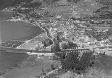
Villeneuve is a municipality in the district of Aigle in the canton of Vaud in Switzerland . The former German name Neuenstadt am Geneva is no longer used today.
geography

Villeneuve is 375 m above sea level. M. , 9 km north-northwest of the district capital Aigle and 4 km south of the city of Montreux (air line). The historic town extends on the east bank of Lake Geneva , to the right of the mouth of the Eau Froide , on the edge of the Rhone plain and at the foot of the Vaudois Alps.
The area of the 32.1 km² municipal area comprises a section on the east bank of Lake Geneva (around 1.5 km in length) and the Vaudois Alps. The western border is formed by the lakeshore and the lower reaches of the canalized Eau Froide; here Villeneuve has a small share of the Rhône plain. In the south, the area extends over the extremely steep forest and rocky slope of Mont d'Arvel to the upper reaches of the Eau Froide mountain stream.
To the east, the municipality extends into the heavily reliefed area of the Vaudois Pre-Alps on both sides of the valley of the Tinière stream . This stream, which flows into Lake Geneva north of Villeneuve in a rubble cone, is crossed by the Malatraix and Pointe d'Aveneyre mountain range ( 2026 m above sea level ) to the south and by the Col de Chaude pass ( 1621 m above sea level ) to the east . ) and to the north by Les Dentaux ( 1714 m above sea level ) and Rochers de Naye (at 2042 m above sea level, the highest point in Villeneuve). East of the Col de Chaude, the area includes the Alp Chaude in the valley of the Ruisseau de Chaude between two mountain ridges of Rochers de Naye and Pointe d'Aveneyre. Like the Ayerne area, this alp is already beyond the main European watershed in the catchment area of the Rhine . The municipal area extends in a narrow corner in the east to the dam walls of the Lac de l'Hongrin , which is drained by the Hongrin to the Saane . In 1997, 8% of the municipal area was in settlements, 53% in forests and woodlands, 26% in agriculture and a little more than 13% was unproductive land.
Villeneuve includes the extensive commercial and industrial area in the plain at the foot of Mont d'Arvel southeast of the town, the southern part of the Grandchamp settlement on the border with Veytaux, the hamlets of Le Crêt ( 439 m above sea level ) and Valeyre ( 485 m above sea level ) on the rubble cone of the Tinière, Plan Cudrey ( 595 m above sea level ) in the valley of the Tinière and some individual farms. Villeneuve's neighboring communities are Veytaux , Rossinière , Château-d'Oex , Ormont-Dessous , Corbeyrier , Roche , Rennaz and Noville .
population
With 5773 inhabitants (as of December 31, 2018) Villeneuve is one of the medium-sized municipalities in the canton of Vaud. 79.5% of the residents are French-speaking, 4.7% German-speaking and 4.1% Italian-speaking (as of 2000). The population of Villeneuve was 1751 in 1900. In the course of the 20th century, the population increased continuously until 1960 (2366 inhabitants). Particularly during the 1960s a strong population growth was recorded (1970 already 3705 inhabitants). After a temporary decrease, a slight increase has been observed again since 1980.
economy

Since the Middle Ages, Villeneuve has lived from trade on the Rhône Valley road and from shipping on Lake Geneva. For a long time it was an agrarian town in which the agricultural products of the surrounding area were processed and sold. In the first half of the 19th century, Villeneuve was drawn into the suction of the emerging tourism on the Vaudois Riviera . The first hotel to open was the Hôtel Byron on the lake shore in 1841 .
Today agriculture is only of minor importance in the employment structure of the population. On the rubbish cone of the Tinière, an area of around 50 hectares is cultivated , while the higher elevations are suitable for cattle breeding and dairy farming . In contrast, the industrial sector plays an important role. At the foot of Mont d'Arvel there are quarries where stone blocks ( Marbre d'Arvel ) of the forthcoming here echinoderms - limestone were mined and in which priority today gravel is produced for railway tracks. The stone was used for individual sculptural objects and the facade design of many buildings in the Lausanne region, but also in the Federal Palace in Bern for interior decoration, for example on the rustic masonry of the base of the Rütli group .
The commercial and industrial area on the level between the railway and the motorway also includes precision engineering workshops, iron trade, window production and the beverage and furniture industry. Numerous other jobs are available in the service sector (including in the hotel and hospitality industry).
In the last few decades, new single-family house quarters have emerged, especially on the northern side of the Tinière rubbish cone. Thanks to its attractive location, Villeneuve has also developed into a residential community. Numerous workers are therefore commuters who mainly work in the Vevey-Montreux region.
traffic

The community is very well developed in terms of transport. It is located on the main road 9 , which leads from Lausanne via Montreux into the Valais . The next motorway junction to the A9 (Lausanne-Sion), which opened in 1970 and crosses the municipality, is around two kilometers from the town center.
On June 10, 1857, the Villeneuve-Bex section of the railway line from Lausanne to Valais was opened. Around four years later, on April 2, 1861, the northern continuation of the line to Lausanne was also put into operation.
At the end of 1900 demonstration drives with an electric vehicle were carried out between Chillon and Villeneuve . This was the first time a trolleybus was used in Switzerland. From 1903 the route was used by the Chillon – Byron – Villeneuve tramway . This in turn was replaced in 1958 by the Vevey-Villeneuve trolleybus , which is operated by Transports publics Vevey-Montreux-Chillon-Villeneuve (VMCV). The bus route from Villeneuve to Vouvry also provides for the fine distribution in public transport . Furthermore, Villeneuve is connected to numerous other maritime communities by passenger shipping on Lake Geneva .
history
Villeneuve can look back on a very long history of settlement. In the area of Le Châtelard east of Villeneuve, traces of settlement from the end of the Paleolithic have been discovered in the Grotte du Scex . They are the oldest evidence of human activity in the canton of Vaud. In the time of the Celts , the settlement Pennelucos was located here , which was also inhabited in Roman times. At that time it was on the important trade route that led from Aventicum (Avenches) via Octodurum (Martigny) over the Great Saint Bernard to Italy . However, there are hardly any remains from the Roman era.
The first documentary mention in modern times took place in 1005 under the name at that time in villa Compendiaco , derived from the Roman surname Compendius . Later, the names Compengiez (1166), Compengie (1207) and 1248 Compesie appeared .
The new town of Villeneuve was founded in 1214 by Count Thomas I of Savoy under the name Villanova Chillionis (la ville neuve de Chillon) in the area of the town of Chillon and given a letter of freedom. This enabled the Savoy to consolidate their position on the east bank of Lake Geneva. As a result, Villeneuve quickly developed into a flourishing trading center and trading center from sea to land transport. It served as a Savoyard military port with war galleys and a shipyard .
During the Burgundian Wars (1476) Villeneuve was affected by raids by the Confederates and was partially burned down. The town remained in the possession of the Savoy, however, lost its importance. It was only with the conquest of Vaud by Bern in 1536 that Villeneuve came under the administration of the Bailiwick of Vevey . After the collapse of the Ancien Régime , the small town belonged to the canton of Léman from 1798 to 1803 during the Helvetic Republic , which then became part of the canton of Vaud when the mediation constitution came into force . In 1798 Villeneuve was assigned to the Aigle district.
During the first half of the 19th century, Villeneuve experienced a new economic boom due to the onset of tourism. It was the residence of many famous people, including Victor Hugo , Richard Wagner , Herbert Kitchener, 1st Earl Kitchener , and Romain Rolland . Today the town of Oskar Kokoschka can count among its honorary citizens.
Since 2012, the altitude of the municipality has been part of the Parc naturel régional Gruyère Pays-d'Enhaut .
Sons and daughters of the church
- Emile Gilliéron (1851–1924), painter and restorer
- Albert Held (1865–1960), entrepreneur
coat of arms
Description : A blue eagle in gold .
Attractions

Villeneuve has a picturesque townscape. The historic old town is now around 150 m from Lake Geneva (during the Middle Ages the lake reached as far as the settlement) and extends with a single longitudinal axis parallel to the lake shore. The city plan covers an area of around 500 m × 100 m and shows several short cross streets. In the past, the city was protected from the land by entrenchments, of which only a few traces have survived near the church. Townhouses and wine-growing houses from the 17th to 19th centuries stand along the longitudinal axis.
The church of Saint-Paul, which belonged to the Cistercian Abbey of Haut-Crêt , existed even before the town was founded . The exact date of today's church is not known, the nave and aisles of which date from the Romanesque era. The rectangular choir in the style of the Cistercians can probably be dated to the early 13th century, while the front tower was built in the 15th century.
From the hospital, which was founded by Aymon of Savoy in 1236, only the former Notre-Dame chapel (13th century) remains. In the place of the hospital is the Hôtel de Ville (town hall), a neo-Gothic building from 1874–76. In Lake Geneva, in front of Villeneuve, there is the natural island Île de Peilz , just big enough to accommodate a single tree.
Web links
- Community information
- Aerial photos of the town
- Michèle Grote: Villeneuve (VD). In: Historical Lexicon of Switzerland .
Individual evidence
- ↑ Permanent and non-permanent resident population by year, canton, district, municipality, population type and gender (permanent resident population). In: bfs. admin.ch . Federal Statistical Office (FSO), August 31, 2019, accessed on December 22, 2019 .
- ^ Toni P. Labhart: Steinführer Bundeshaus Bern . Bern 2002, pp. 29, 39 ISBN 3-85782-719-X
- ^ Michel Septfontaine, Stefan Ansermet: Belles et utiles pierres de chez nous . Musée géologique Lausanne, Lausanne 1999, p. 27 ISBN 2-9700149-1-2
- ↑ Trackless railways in the encyclopedia of railways
- ^ Evelyne Lüthi-Graf: Chillon. In: Historical Lexicon of Switzerland . July 15, 2005 , accessed June 5, 2019 .
Aigle | Bex | Chessel | Corbeyrier | Gryon | Lavey-Morcles | Leysin | Noville | Ollon | Ormont lingerie | Ormont-Dessus | Rennaz | Roche (VD) | Villeneuve (VD) | Yvorne
Former parishes: Lavey | Morcles
Canton of Vaud | Districts of the canton of Vaud | Municipalities of the canton of Vaud
← Previous location: Montreux 3.5 km | Villeneuve VD | Next town: Aigle 12.7 km →
![]() Canterbury |
Dover |
Calais |
Wissant |
Guînes |
Licques |
Wisques |
Thérouanne |
Auchy-au-Bois |
Bruay-la-Buissière |
Arras |
Bapaume |
Peronne |
Doingt |
Seraucourt-le-Grand |
Tergnier |
Laon |
Bouconville-Vauclair |
Corbeny |
Hermonville |
Reims |
Trépail |
Châlons-en-Champagne |
Cool |
Brienne-le-Château |
Bar-sur-Aube |
Châteauvillain |
Blessonville |
Langres |
Humes-Jorquenay |
Coublanc |
Grenant |
Dampierre-sur-Salon |
Savoyeux |
Seveux |
Gy |
Cussey-sur-l'Ognon |
Besançon |
Étalans |
Chasnans |
Nods |
Ouhans |
Pontarlier |
Yverdon-les-Bains |
Orbe |
Lausanne |
Cully |
Vevey |
Montreux |
Villeneuve |
Aigle |
Saint-Maurice |
Martigny |
Orsières |
Bourg-Saint-Pierre |
Great St. Bernhard |
Saint-Rhémy-en-Bosses |
Saint-Oyen |
Étroubles |
Gignod |
Aosta |
Saint-Christophe |
Quart |
Nut |
Verrayes |
Chambave |
Saint-Denis |
Châtillon |
Saint-Vincent |
Montjovet |
Issogne |
Verrès |
Arnad |
Hône |
Bard |
Donnas |
Pont-Saint-Martin |
Carema |
Settimo Vittone |
Borgofranco d'Ivrea |
Montalto Dora |
Ivrea |
Cascinette d'Ivrea |
Burolo |
Bollengo |
Palazzo Canavese |
Piverone |
Azeglio |
Viverone |
Roppolo |
Cavaglià |
Santhià |
San Germano Vercellese |
Olcenengo |
Salasco |
Sali Vercellese |
Vercelli |
Palestro |
Robbio |
Nicorvo |
Castelnovetto |
Albonese |
Mortara |
Cergnago |
Tromello |
Garlasco |
Gropello Cairoli |
Villanova d'Ardenghi |
Zerbolò |
Carbonara al Ticino |
Pavia |
Valle Salimbene |
Linarolo |
Belgioioso |
Torre de 'Negri |
Costa de 'Nobili |
Santa Cristina e Bissone |
Miradolo Terme |
Chignolo Po |
San Colombano al Lambro |
Orio Litta |
Senna Lodigiana |
Calendasco |
Rottofreno |
Piacenza |
Podenzano |
San Giorgio Piacentino |
Pontenure |
Carpaneto Piacentino |
Cadeo |
Fiorenzuola d'Arda |
Chiaravalle della Colomba |
Alseno |
Busseto |
Fidenza |
Costamezzana |
Noceto |
Medesano |
Fornovo di Taro |
Terenzo |
Berceto |
Pontremoli |
Filattiera |
Villafranca in Lunigiana |
Bagnone |
Licciana Nardi |
Aulla |
Santo Stefano di Magra |
Sarzana |
Castelnuovo Magra |
Ortonovo |
Luni |
Fosdinovo |
Carrara |
Massa |
Montignoso |
Seravezza |
Pietrasanta |
Camaiore |
Lucca |
Capannori |
Porcari |
Montecarlo |
Altopascio |
Castelfranco di Sotto |
Santa Croce sull'Arno |
Ponte a Cappiano |
Fucecchio |
San Miniato |
Castelfiorentino |
Coiano |
Montaione |
Gambassi Terme |
San Gimignano |
Colle di Val d'Elsa |
Badia a Isola |
Monteriggioni |
Siena |
Monteroni d'Arbia |
Ponte d'Arbia |
Buonconvento |
Montalcino |
Torrenieri |
San Quirico d'Orcia |
Bagno Vignoni |
Castiglione d'Orcia |
Radicofani |
San Casciano dei Bagni |
Abbadia San Salvatore |
Piancastagnaio |
Ponte a Rigo |
Proceno |
Acquapendente |
Grotte di Castro |
San Lorenzo Nuovo |
Bolsena |
Montefiascone |
Viterbo |
Ronciglione |
Vetralla |
Capranica |
Sutri |
Monterosi |
Nepi |
Mazzano Romano |
Campagnano di Roma |
Formello |
La Storta |
Rome
Canterbury |
Dover |
Calais |
Wissant |
Guînes |
Licques |
Wisques |
Thérouanne |
Auchy-au-Bois |
Bruay-la-Buissière |
Arras |
Bapaume |
Peronne |
Doingt |
Seraucourt-le-Grand |
Tergnier |
Laon |
Bouconville-Vauclair |
Corbeny |
Hermonville |
Reims |
Trépail |
Châlons-en-Champagne |
Cool |
Brienne-le-Château |
Bar-sur-Aube |
Châteauvillain |
Blessonville |
Langres |
Humes-Jorquenay |
Coublanc |
Grenant |
Dampierre-sur-Salon |
Savoyeux |
Seveux |
Gy |
Cussey-sur-l'Ognon |
Besançon |
Étalans |
Chasnans |
Nods |
Ouhans |
Pontarlier |
Yverdon-les-Bains |
Orbe |
Lausanne |
Cully |
Vevey |
Montreux |
Villeneuve |
Aigle |
Saint-Maurice |
Martigny |
Orsières |
Bourg-Saint-Pierre |
Great St. Bernhard |
Saint-Rhémy-en-Bosses |
Saint-Oyen |
Étroubles |
Gignod |
Aosta |
Saint-Christophe |
Quart |
Nut |
Verrayes |
Chambave |
Saint-Denis |
Châtillon |
Saint-Vincent |
Montjovet |
Issogne |
Verrès |
Arnad |
Hône |
Bard |
Donnas |
Pont-Saint-Martin |
Carema |
Settimo Vittone |
Borgofranco d'Ivrea |
Montalto Dora |
Ivrea |
Cascinette d'Ivrea |
Burolo |
Bollengo |
Palazzo Canavese |
Piverone |
Azeglio |
Viverone |
Roppolo |
Cavaglià |
Santhià |
San Germano Vercellese |
Olcenengo |
Salasco |
Sali Vercellese |
Vercelli |
Palestro |
Robbio |
Nicorvo |
Castelnovetto |
Albonese |
Mortara |
Cergnago |
Tromello |
Garlasco |
Gropello Cairoli |
Villanova d'Ardenghi |
Zerbolò |
Carbonara al Ticino |
Pavia |
Valle Salimbene |
Linarolo |
Belgioioso |
Torre de 'Negri |
Costa de 'Nobili |
Santa Cristina e Bissone |
Miradolo Terme |
Chignolo Po |
San Colombano al Lambro |
Orio Litta |
Senna Lodigiana |
Calendasco |
Rottofreno |
Piacenza |
Podenzano |
San Giorgio Piacentino |
Pontenure |
Carpaneto Piacentino |
Cadeo |
Fiorenzuola d'Arda |
Chiaravalle della Colomba |
Alseno |
Busseto |
Fidenza |
Costamezzana |
Noceto |
Medesano |
Fornovo di Taro |
Terenzo |
Berceto |
Pontremoli |
Filattiera |
Villafranca in Lunigiana |
Bagnone |
Licciana Nardi |
Aulla |
Santo Stefano di Magra |
Sarzana |
Castelnuovo Magra |
Ortonovo |
Luni |
Fosdinovo |
Carrara |
Massa |
Montignoso |
Seravezza |
Pietrasanta |
Camaiore |
Lucca |
Capannori |
Porcari |
Montecarlo |
Altopascio |
Castelfranco di Sotto |
Santa Croce sull'Arno |
Ponte a Cappiano |
Fucecchio |
San Miniato |
Castelfiorentino |
Coiano |
Montaione |
Gambassi Terme |
San Gimignano |
Colle di Val d'Elsa |
Badia a Isola |
Monteriggioni |
Siena |
Monteroni d'Arbia |
Ponte d'Arbia |
Buonconvento |
Montalcino |
Torrenieri |
San Quirico d'Orcia |
Bagno Vignoni |
Castiglione d'Orcia |
Radicofani |
San Casciano dei Bagni |
Abbadia San Salvatore |
Piancastagnaio |
Ponte a Rigo |
Proceno |
Acquapendente |
Grotte di Castro |
San Lorenzo Nuovo |
Bolsena |
Montefiascone |
Viterbo |
Ronciglione |
Vetralla |
Capranica |
Sutri |
Monterosi |
Nepi |
Mazzano Romano |
Campagnano di Roma |
Formello |
La Storta |
Rome![]()
![]()
![]()