Leysin
| Leysin | |
|---|---|
| State : |
|
| Canton : |
|
| District : | Aigle |
| BFS no. : | 5407 |
| Postal code : | 1854 |
| Coordinates : | 567 212 / 132343 |
| Height : | 1253 m above sea level M. |
| Height range : | 670–2331 m above sea level M. |
| Area : | 18.57 km² |
| Residents: | 3970 (December 31, 2018) |
| Population density : | 214 inhabitants per km² |
|
Proportion of foreigners : (residents without citizenship ) |
61.7% (2,011) |
| Website: | www.leysin-commune.ch |
|
Leysin |
|
| Location of the municipality | |
Leysin ( French [ lɛzɛ̃ ], in the native Franco-Provencal dialect [ (ɛː) laː ͤtsɛ̃ ͥ ]) is a municipality in the district of Aigle in the Swiss canton of Vaud .
geography
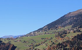
Leysin lies at 1253 m above sea level. M. , 4 km northeast of the district capital Aigle (air line). The village extends on a wide terrace on the southern slope of the Tour d'Aï, high above the valley of the Grande Eau , in a panoramic position east of the Rhone valley .
The area of the 18.5 km² municipal area covers a section of the Vaudois Alps. In the southern part of the area is the terrace of Leysin (around 1250 m above sea level ), which is bordered against the valley of the Grande Eau by a series of forest hills parallel to the slope. Interrupted by the valley of the Ruisseau de Ponty , the terrace continues to the south-west in the basin of Veyges. In the south, the communal soil extends into the valley of the Grande Eau, which drains the area to the Rhône.
In the west, the border runs along the mountain ridge of La Riondaz and Berneuse ( 2045 m above sea level ). To the north, the municipality extends over alpine meadows to the striking limestone mountain ranges of Tour d'Aï (at 2331 m above sea level, the highest point of Leysin), Tour de Mayen ( 2326 m above sea level ) and Tour de Famelon ( 2138 m above sea level ). The mountain lakes Lac d'Aï , Lac de Mayen and Lac Segray are located in hollows on the southern slope of these mountains . In 1997, 7% of the municipal area was in settlements, 37% in forests and woodland, 33% in agriculture and a little less than 23% was unproductive land.
Leysin includes the district of Feydey ( 1398 m above sea level ) above the village, the settlement of Les Esserts ( 1340 m above sea level ) northeast of Leysin, the hamlet of En Crettaz ( 1225 m above sea level ) on the terrace to the north des Flot de Crête and Veyges ( 1113 m above sea level ) in a hollow between the mountainside and the Efflot de Veyges, the Alpine settlements Aï ( 1892 m above sea level ) on Lac d'Aï and Mayen ( 1842 m above sea level) . ) at Lac de Mayen as well as some individual farms. Neighboring communities of Leysin are Aigle , Yvorne , Corbeyrier and Ormont-Dessous .
population
With 3970 inhabitants (as of December 31, 2018) Leysin is one of the medium-sized municipalities in the canton of Vaud. 56.1% of the residents are French-speaking, 11.9% English-speaking and 3.5% German-speaking (as of 2000). The population of Leysin amounted to 1065 in 1900. In the course of the 20th century, the population grew steadily (1970: 2752 inhabitants). After a temporary sharp decline during the 1970s, the population has been increasing again since then. Leysin is the Swiss municipality with the highest proportion of foreigners (61.7 percent, as of 2011).
economy
Until the end of the 19th century, Leysin was predominantly an agricultural village. After that, with the improved transport connections (road and rail), a rapid development into a recreational and climatic health resort began, especially the treatment of tuberculosis sufferers.
Today, dairy farming and cattle breeding only play a minor role in the employment structure of the population. Most jobs are in local small businesses and especially in the service sector. The industry is entirely geared towards the needs of tourism. Leysin is the seat of the American College of Switzerland (ACS - part of Schiller International University) and the location of the renowned Leysin American School (LAS) and the Kumon Leysin Academy of Switzerland (KLAS). There is also a hotel management school and several language schools. Since 1956 there is a branch of the Club Méditerranée in the place .
tourism
From around 1870 Leysin developed into an important climatic health resort ; tourism started and many new hotels were built. Around 1900 Leysin gained an international reputation as a treatment center for tuberculosis sufferers . The patients were subjected to sun therapy, for which Leysin, with its south-facing slope, protected from cold north winds and mostly above the haze and high fog cover of the Rhone Valley, was particularly suitable. As a result, numerous sanatoriums were built (around 80 in total during the boom). At the same time, Leysin was also expanded into a winter sports resort.
After antibiotics for the treatment of lung diseases had been discovered, the mountain health resort suffered an economic slump after the Second World War . Most of the sanatoriums were closed or converted into hotels and holiday apartments. The economic decline could be compensated by the resurgence of tourism since the 1950s.
Today Leysin is a modern tourism and sports center, geared towards both winter and summer tourism. The slopes and Alps of Aï and Mayen are accessible by several mountain railways and ski lifts. The modern panorama revolving restaurant Kuklos is located on the summit of the Berneuse . The area around the Tour d'Aï, Tour de Mayen and Tour de Famelon with the three mountain lakes is a popular hiking destination.
traffic
The community is located away from the major thoroughfares. It is accessed by a spur road from Le Sépey on the main road 11 Aigle-Col des Mosses. On November 6, 1900, the Aigle – Leysin (AL) rack railway , which is operated today by the Transports Publics du Chablais (TPC), was inaugurated with three stops in Leysin. The bus line that runs from Le Sépey to Leysin takes care of the fine distribution in public transport.
history

The first written mention of the place took place in 1232 as Leissins . The place name is derived from a Latin personal name Latius or Lesius with the place name suffix -ānum .
The old town center of Leysin lies on a terrace behind a forest knoll and cannot be seen from the Rhône valley. The former residents lived in great isolation, but were not affected by any raids in the Rhône valley. Since the Middle Ages Leysin belonged to the Duchy of Savoy and was ecclesiastically and administratively dependent on Aigle.
With the conquest of Aigle by Bern in 1476, Leysin came under the administration of the Aigle governorate . The Reformation was introduced in the village in 1528. It was not until 1702 that Leysin became an independent political municipality. After the collapse of the Ancien Régime , the village belonged to the canton of Léman from 1798 to 1803 during the Helvetic Republic , which then became part of the canton of Vaud when the mediation constitution came into force . In 1798 it was assigned to the Aigle district.
Leysin first achieved greater notoriety in 1789 through the book Essay upon the principles of population , in which Thomas Malthus described the relatively long life of the villagers (61 years) compared to other European communities. He attributed this fact to the healthy climate and the seclusion (the inhabitants are largely spared from contagious diseases of the valley population). This book was the basis for Leysin becoming internationally known in the early 19th century, initially as a place of recovery for the surrounding region, and from around 1870 onwards.
Community merger
The municipality of Leysin pursued a merger project with the neighboring municipalities of Aigle and Yvorne in 2010 . In the referendum on September 26, 2010, the project narrowly failed due to a negative majority of 43 votes in the municipality of Aigle:
| local community | Yes | No |
|---|---|---|
| Aigle | 1168 (49%) | 1211 (51%) |
| Leysin | 455 (53%) | 403 (47%) |
| Yvorne | 252 (52%) | 232 (48%) |
Attractions
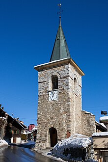
The core of the reformed Saint-Nicolas church dates from 1445, but was converted to Baroque style in the 17th century . The townscape of Leysin is characterized by hotel and sanatorium buildings (meanwhile renovated and redesigned) from around 1900, including the Grand Hotel from 1892.
Personalities
Sons and daughters of the church
- Silvio Giobellina (* 1954), bobsleigh athlete, world champion in four-man bobsleigh
Web links
- Official website of the municipality of Leysin (French)
- Jean-Jacques Bouquet: Leysin. In: Historical Lexicon of Switzerland .
- Website of the Leysin tourist region
- Aerial views of the village and its surroundings
Individual evidence
- ↑ Permanent and non-permanent resident population by year, canton, district, municipality, population type and gender (permanent resident population). In: bfs. admin.ch . Federal Statistical Office (FSO), August 31, 2019, accessed on December 22, 2019 .
- ↑ a b 7,952,555 people live in Switzerland , Tagesschau (SRF) , from April 26, 2012, accessed on April 27, 2012
- ↑ a b Lexicon of Swiss municipality names . Edited by the Center de Dialectologie at the University of Neuchâtel under the direction of Andres Kristol. Huber, Frauenfeld / Stuttgart / Vienna 2005, ISBN 3-7193-1308-5 and Payot, Lausanne 2005, ISBN 2-601-03336-3 , p. 532.
- ↑ Site internet du projet de fusion http://www.projet-fusion.ch/
- ↑ Résultat de la votation sur le site de la commune d'Aigle Archived copy ( Memento of the original of September 30, 2010 in the Internet Archive ) Info: The archive link was inserted automatically and has not yet been checked. Please check the original and archive link according to the instructions and then remove this notice.


