
Lavey-Morcles
| Lavey-Morcles | |
|---|---|
.svg) |
|
| State : |
|
| Canton : |
|
| District : | Aigle |
| BFS no. : | 5406 |
| Postal code : | 1892 |
| Coordinates : | 567609 / 118753 |
| Height : | 444 m above sea level M. |
| Height range : | 402–2924 m above sea level M. |
| Area : | 14.20 km² |
| Residents: | 946 (December 31, 2018) |
| Population density : | 67 inhabitants per km² |
| Website: | www.lavey.ch |
 Lavey-Morcles |
|
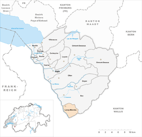
| Location of the municipality | |
  |
|
Lavey-Morcles is a municipality in the district of Aigle in the canton of Vaud in Switzerland . The place became famous through a sulfur spring that is used to operate a thermal bath.
geography
Lavey-Morcles is located 12 km south-southeast of the district capital Aigle (beeline). The village of Lavey-Village extends at 444 m above sea level. M. in a basin filled with alluvial material from the Le Courset mountain stream east of the Rhone , opposite Saint-Maurice , between the mountain ranges of Dents du Midi in the west and Dent de Morcles in the east.
The area of the 14.2 km² municipal area covers a section of the Vaudois Alps. The western limit is the Rhône. This is followed in the east by a narrow valley plain from which the steep rocky, partly forest-covered slopes of the Dent de Morcles rise. This 2500 m high western slope of the Dent de Morcles is subdivided by three notch valleys: In the south (border against the Valais) the slope run of the Torrent Sec , north of it the valley of the Avançon (de Morcles) and the northern border forming the Courset , which at the foot of the slope south of the hill area of Chiètres has accumulated a large amount of alluvial material over time. Above the tree line, here at around 1800 to 2000 m, there are steep alpine meadows. In the east, the municipal boundary runs over the ridge of Croix de Javerne ( 2097 m above sea level ) and Pointe des Martinets ( 2638 m above sea level ) and reaches the Petite Dent de Morcles at 2929 m above sea level on the rocky summit . M. the highest point of Lavey-Morcles. In 1997, 5% of the municipal area was in settlements, 62% in forests and woodlands, 19% in agriculture and a little less than 14% was unproductive land.
Lavey-Morcles consists of the districts Lavey-Village ( 444 m above sea level ), Lavey-les-Bains ( 415 m above sea level ) in the valley east of the Rhône and the mountain village of Morcles ( 1160 m above sea level ) on the southern slope of the foothill L'Aiguille in the Avançon valley. In addition, the hamlet Eslex ( 511 m above sea level ) on a narrow terrace at the foot of the Dent de Morcles slope, the military facilities Savatan ( 700 m above sea level ) and Dailly ( 1250 m above sea level ) on the slope of the Aiguille belong as well as some individual farms and Alps to Lavey-Morcles. Neighboring communities of Lavey-Morcles are Bex in the canton of Vaud and Saint-Maurice and Collonges in the canton of Valais .
population
With 946 inhabitants (as of December 31, 2018) Lavey-Morcles is one of the smaller municipalities in the canton of Vaud. 89.0% of the residents are French-speaking, 5.4% German-speaking and 2.3% speak Serbo-Croatian (as of 2000). The population of Lavey-Morcles was 319 in 1850 and 789 in 1900. During the 20th century the population fluctuated between 730 and 860 inhabitants.
economy
Until the beginning of the 20th century, Lavey-Morcles was predominantly an agricultural village. Even today arable farming and some viticulture in the lower elevations as well as dairy farming and cattle breeding in the higher elevations have a certain role in the income structure of the population. Further jobs are available in local small businesses and especially in the service sector. The power station, built in 1888, is owned by the city of Lausanne . In 1891 the military fortifications Savatan and Dailly were built on the strategically easy-to-control narrow point of the Rhône Valley. The army is still one of the most important employers in Lavey-Morcles. In the last few decades the village has also developed into a residential community. Many workers are commuters who work in the larger municipalities of the Rhône Valley.
tourism
In 1831 the hot sulfur springs of Lavey were discovered by chance . The two springs produce sulphurous water with a temperature of 62 to 69 ° C and a discharge of 400 to 600 liters per minute from a depth of around 200 to 600 m. By using the springs, Lavey-les-Bains became a spa. Today there is a modern thermal bath (with outdoor pool) and health center.
traffic
The community is located off the main thoroughfares, but can be easily reached from Saint-Maurice . The next motorway connection to the A9 (Lausanne-Sion) is around 3 km from the town center (exit 20 St-Maurice). Lavey-Village and Lavey-les-Bains are linked to Saint-Maurice by a postbus course and are thus connected to the public transport network.
history
The first written mention of Lavey was in 1016 under the name A Laver ; In 1180 the name Lavetum appeared . The place name is derived from the Latin word lavare (to wash). The name Morcles has also been passed down since 1043.
The areas of Lavey and Morcles belonged to Saint-Maurice Abbey from the 11th century. With the conquest of Aigle by Bern in 1476, Lavey and Morcles came under the administration of the Aigle governorate . While Morcles was always dependent on Bex, Lavey only belonged to Kastlanei Bex until 1564 and then formed its own bailiwick. After the collapse of the Ancien Régime , Lavey and Morcles belonged to the canton of Léman from 1798 to 1803 during the Helvetic Republic , which then became part of the canton of Vaud when the mediation constitution came into force . In 1798 the villages were assigned to the Aigle district.
Against the will of the residents of the remote mountain village of Morcles, which had 68 inhabitants in 1850, the merger with Lavey was completed in 1852 to form the new municipality of Lavey-Morcles.
coat of arms
Description : A red armed silver rooster in green .
Attractions
The Lavey-Village Reformed Church was built in 1889. The Catholic Church dates from 1900.
Personalities
- Charles Petter (1880–1953), weapons designer
Web links
- Official website of the municipality of Lavey-Morcles (French)
- Germain Hausmann: Lavey-Morcles. In: Historical Lexicon of Switzerland .
- Germain Hausmann: Morcles. In: Historical Lexicon of Switzerland .
- Aerial views of Lavey-Village and Lavey-les-Bains
- Aerial view of the mountain village of Morcles
- Website of the Lavey-les-Bains thermal baths
Individual evidence
- ↑ Permanent and non-permanent resident population by year, canton, district, municipality, population type and gender (permanent resident population). In: bfs. admin.ch . Federal Statistical Office (FSO), August 31, 2019, accessed on December 22, 2019 .
Aigle | Bex | Chessel | Corbeyrier | Gryon | Lavey-Morcles | Leysin | Noville | Ollon | Ormont lingerie | Ormont-Dessus | Rennaz | Roche (VD) | Villeneuve (VD) | Yvorne
Former parishes: Lavey | Morcles
Canton of Vaud | Districts of the canton of Vaud | Municipalities of the canton of Vaud